Askja Caldera Trail - Journey into the Lunar Heart of Iceland
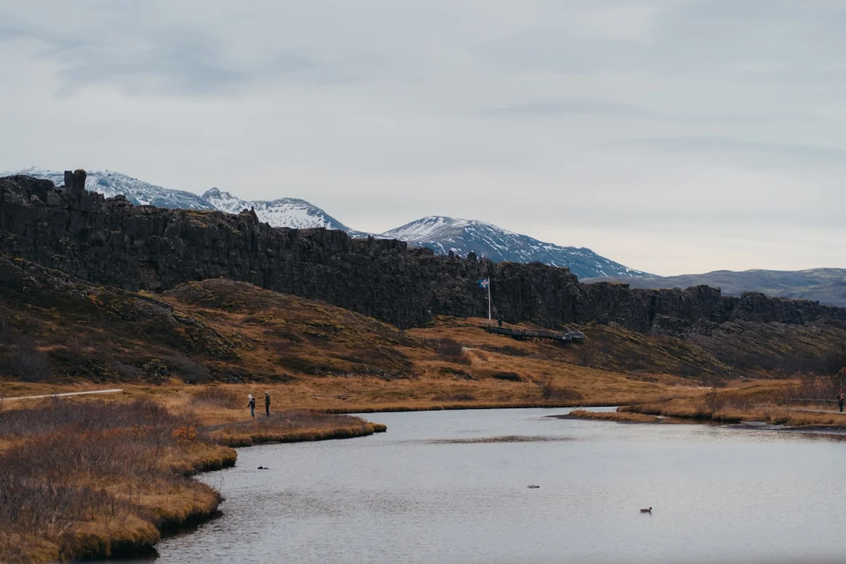
The Askja Caldera Trail is one of the most profound wilderness experiences in the northern hemisphere—a 60-kilometre trek through the raw, volcanic soul of the Icelandic Highlands. Located within the Dyngjufjöll mountains on the northern edge of the Vatnajökull National Park, this route traverses a landscape so otherworldly that it was famously used by NASA to train Apollo astronauts for lunar landings. This is not a trail of lush forests or rolling meadows; it is a journey through vast deserts of black tephra, jagged obsidian lava fields, and towering rhyolite peaks that shimmer with ethereal colours under the midnight sun. The centrepiece of the trek is the massive Askja caldera itself, a 45-square-kilometre collapse feature containing the sapphire-blue Lake Öskjuvatn and the milky-teal, geothermal Viti crater.
Accessing the Askja region is an adventure in its own right, requiring a high-clearance 4x4 vehicle and the negotiation of unbridged glacial rivers. The trail typically begins at the Draumakofa hut or the Dreki mountain station, weaving through the heart of the Odadahraun—the "Desert of Misdeeds"—Iceland’s largest lava field. This is a place of absolute silence, where the scale of the geology humbles the human spirit and the weather can shift from sun-drenched stillness to a blinding sandstorm in minutes. For those seeking a true escape from the modern world, the Askja Caldera Trail offers a stark, minimalist beauty that is unmatched anywhere else on Earth.
- Distance: 60.0 km (loop or point-to-point variations)
- Duration: 2–3 days
- Season: Late June to August (strictly dependent on F-road openings)
- Accommodation: Mountain huts (Draumakofa, Dreki, Dyngjufell) and designated campsites
- Highest point: Approximately 1,300 metres (rim of the caldera)
- Difficulty: Challenging (due to navigation, terrain, and extreme isolation)
- Closest City: Akureyri (approx. 4–6 hours driving time)
Overview
The Askja Caldera Trail is a masterclass in volcanic geology and high-altitude desert trekking. Unlike the popular Laugavegur trail to the south, Askja remains relatively uncrowded, offering a sense of isolation that is increasingly rare in Iceland. The route is defined by the Dyngjufjöll massif, a cluster of mountains that rose through the ice during the last glacial period. The caldera at its heart is a nested system of three subsidences, the most recent of which was formed during a cataclysmic eruption in 1875. Walking here is a sensory experience: the crunch of pumice underfoot, the smell of sulphur wafting from geothermal vents, and the sight of the vast, empty horizon of the interior highlands.
The trek is physically demanding, not necessarily because of extreme elevation gain—the total ascent is a manageable 800 metres—but because of the terrain. Hikers must navigate through "Aa" lava (sharp, jagged blocks) and "Pahoehoe" lava (smooth, ropey flows), as well as deep fields of volcanic ash that can make every step feel like walking through heavy sand. Water is a critical logistical challenge; the porous volcanic soil swallows rainfall instantly, meaning there are long stretches with no surface water. Success on this trail requires meticulous planning, a robust physical constitution, and a deep respect for the unpredictable nature of the Icelandic interior.
The visual rewards, however, are staggering. Standing on the rim of the Askja caldera, looking down at the 220-metre-deep Lake Öskjuvatn—the second deepest lake in Iceland—is a moment of profound awe. Beside it, the smaller Viti crater (meaning "Hell") offers the surreal opportunity to swim in geothermal waters surrounded by a frozen landscape of snow and ash. The light in the highlands is legendary; during the peak of summer, the sun barely dips below the horizon, casting long, golden shadows across the black sands and turning the rhyolite mountains into glowing beacons of ochre and violet.
History and Cultural Context
The history of Askja is a saga of geological violence and human exploration. For centuries, the region was part of the "Odadahraun," a vast, trackless lava desert that was feared by Icelanders. Folklore suggested it was the haunt of outlaws and evil spirits, a place where no God-fearing person would venture. It remained largely unexplored until the late 19th century. The event that changed everything was the massive explosive eruption of 1875. This eruption was so powerful that its ash reached as far as Norway and Sweden, and it devastated the farming communities of East Iceland, triggering a wave of emigration to North America. The eruption caused the roof of the central magma chamber to collapse, creating the caldera and the depression that eventually filled with water to become Lake Öskjuvatn.
In 1907, the region became the site of a haunting mystery. Two German scientists, Walter von Knebel and Max Rudloff, arrived to study the caldera. While exploring Lake Öskjuvatn in a small boat, they vanished without a trace. Von Knebel’s fiancée, Ina von Grumbkow, led an expedition the following year to find them, but no remains were ever discovered. Today, a small memorial plaque stands near the lake, a somber reminder of the dangers inherent in this volatile landscape. The mystery of their disappearance continues to fascinate historians and geologists alike.
In the 1960s, Askja gained international fame for a different reason. NASA geologists identified the area as the most moon-like terrain on Earth. In 1965 and 1967, groups of Apollo astronauts, including Neil Armstrong and Buzz Aldrin, were sent to the Askja region to practice geological sampling and to familiarise themselves with the challenges of navigating a barren, volcanic environment. The astronauts stayed in the Dreki huts and spent their days exploring the lava fields, a history that adds a layer of cosmic significance to every step a modern hiker takes on the trail. The local community in Akureyri and the nearby Husavik still celebrate this connection through the Exploration Museum.
Want more background? Read extended notes on history and cultural context → Learn more
Seasonal Highlights and Weather Reality
The window for hiking the Askja Caldera Trail is exceptionally narrow. Because the trail is located in the high interior, the access roads (F-roads) are closed by snow for most of the year. Typically, the roads F88 and F910 do not open until late June or early July, and they often close again by early September. Even during the peak of summer, the weather in the highlands is notoriously fickle. It is not uncommon to experience a snowstorm in the middle of July, followed by temperatures of 20 degrees Celsius the next day.
Summer (July to August): This is the only viable time for the trek. The days are characterised by 24-hour daylight, which provides a safety margin for navigation but can disrupt sleep patterns. The primary weather hazards during this time are high winds and sandstorms. When the wind picks up across the Odadahraun, it carries fine volcanic dust that can reduce visibility to a few metres and scour exposed skin. Rain is frequent, often coming in horizontal sheets, and the temperature at night regularly drops toward freezing.
Shoulder Season (Late June and Early September): Attempting the trail during these windows is a gamble. In late June, large snow patches often cover the trail, making navigation difficult and increasing the risk of falling through snow bridges over hidden lava fissures. In September, the days shorten rapidly, and the first major autumn storms can bring heavy snow and sub-zero temperatures, potentially stranding hikers and vehicles. There are no services in the area outside of the peak summer months, and the wardens at Dreki depart once the roads are officially closed.
Winter (October to May): The Askja region is strictly off-limits to all but the most experienced polar explorers during winter. The area is buried under metres of snow, and the winds can reach hurricane force. Access is only possible via modified "Super Jeeps" or on skis, and the risk of extreme hypothermia and getting lost is absolute. For the recreational hiker, winter is a time to stay away and plan for the following summer.
Recommended Itinerary
3-Day Askja Caldera Trek
Day 1: Draumakofa Hut to Dreki Mountain Station
- Distance: 22 km
- Elevation gain: 300 m
- Time: 7–9 hours
- Start at the remote Draumakofa hut, located in the shadow of the Dyngjufjöll mountains.
- The trail heads southeast across the vast black sands of the Odadahraun.
- Navigate through the "New Lava" fields from the 2014 Holuhraun eruption (if taking the extended route).
- Pass through the dramatic Drekagil (Dragon Ravine), a narrow canyon with twisted basalt formations.
- Arrive at Dreki Mountain Station, a cluster of huts managed by the Akureyri Touring Club (FFA).
- This day is a test of endurance on flat but soft volcanic terrain.
- The silence of the desert is the defining characteristic of this leg.
Day 2: Dreki to Askja Caldera and Viti Crater (Loop)
- Distance: 16 km (return)
- Elevation gain: 400 m
- Time: 6–8 hours
- A steady climb from Dreki up onto the shoulder of the Dyngjufjöll mountains.
- The trail enters the main Askja caldera through a gap in the rim.
- Walk across the flat caldera floor toward the edge of Lake Öskjuvatn.
- Descend into the Viti crater for a swim in the milky-blue, 25°C geothermal water (check conditions with wardens first).
- Explore the rim of the caldera for panoramic views of the interior highlands and the distant Vatnajökull ice cap.
- Return to Dreki via the same route or a slightly different path through the lava.
- This is the highlight of the trip, offering the most iconic views of the volcanic landscape.
Day 3: Dreki to Dyngjufell Hut
- Distance: 22 km
- Elevation gain: 100 m
- Time: 7–9 hours
- Head north from Dreki, skirting the eastern edge of the Dyngjufjöll mountains.
- The route traverses ancient, weathered lava flows and high-altitude plateaus.
- Pass through areas of bright yellow rhyolite that contrast sharply with the black basalt.
- Arrive at the Dyngjufell hut, a small, basic shelter tucked into a mountain fold.
- This section is remote and requires careful navigation, as the trail markers can be sparse.
- From Dyngjufell, hikers can be picked up by a pre-arranged 4x4 or continue north toward Herðubreiðarlindir.
Important Notes:
- Water is extremely scarce; you must carry at least 3–4 litres per day.
- The trail is marked with yellow stakes, but these can be knocked down by wind or buried by sand.
- GPS is mandatory; do not rely on visual navigation alone.
- Check in with the wardens at Dreki for the latest weather and trail conditions.
- The swim in Viti requires a steep, slippery descent; use caution.
- River crossings on the drive in can be deep; always check the depth before entering.
Planning and Bookings
Book Your Trip
Everything you need to plan your journey
Accommodation
Find places to stay near Akureyri
Flights
Search flights to Akureyri
Essential Preparation
Planning a trip to Askja is significantly more complex than a standard European hike. The primary hurdle is logistics. You must have a 4x4 vehicle to reach the trailhead. Standard rental cars are strictly prohibited on F-roads, and attempting to drive one here will void your insurance and likely result in a stranded vehicle and a very expensive rescue fee. The most common base for the trip is Akureyri, the "Capital of the North," which has all the necessary services, including supermarkets, outdoor gear shops, and car rental agencies specialising in highland vehicles.
Fitness requirements are moderate to high. While the elevation gain isn't extreme, the uneven and soft terrain is taxing on the ankles and knees. You should be comfortable walking 20+ kilometres a day with a full pack. Furthermore, you must be self-sufficient in navigation. There are no signposts with distances, and in a sandstorm, you will lose all visual landmarks. Familiarise yourself with your GPS device and carry spare batteries.
Trail Accommodation
Accommodation in the Askja region is managed primarily by the Akureyri Touring Club (Ferðafélag Akureyrar - FFA). There are three main options for hikers on this route.
Dreki Huts: The main hub. There are two large huts that can accommodate about 60 people in total. They feature bunk beds with mattresses, a shared kitchen with gas stoves, and a separate building with toilets and showers (showers require a small fee). During the summer, wardens are stationed here to provide information and manage bookings.
Draumakofa and Dyngjufell Huts: These are much smaller and more basic "emergency" style huts. They provide shelter and bunks but have very limited facilities. You should not rely on finding space here without prior coordination, and you must bring your own cooking equipment.
Camping: There is a designated campsite at Dreki. Camping is only allowed in designated areas to protect the fragile volcanic soil. The ground is hard and rocky, so sturdy tent pegs are essential. There is no shade or wind protection, so your tent must be high-quality and capable of withstanding gale-force winds.
Booking Requirements: Hut spaces sell out months in advance. You can book through the FFA website. Camping does not usually require a pre-booking but you must register with the warden upon arrival. Costs for huts are approximately 10,000 to 12,000 ISK per night, while camping is around 2,500 ISK per person.
Required Gear
- Footwear: Sturdy, waterproof hiking boots with high ankle support. The lava is sharp and will shred lightweight trail runners.
- Navigation: High-quality GPS unit with topographical maps pre-loaded. A compass and paper map are essential backups.
- Clothing: A complete layering system. This includes merino wool base layers, a fleece or down mid-layer, and a professional-grade waterproof and windproof shell (Gore-Tex or similar).
- Tent: If camping, a 4-season tent is highly recommended due to the potential for extreme winds.
- Sleeping Bag: A bag with a comfort rating of at least -5°C. Even in summer, the highland nights are cold.
- Backpack: A 50–70 litre pack with a waterproof cover and internal dry bags for your gear.
- Eye Protection: Wrap-around sunglasses or even ski goggles to protect your eyes from blowing volcanic sand.
What to Bring
- Food: All food for the duration of the trek. There are no shops or restaurants in the highlands. Bring calorie-dense, lightweight dehydrated meals, nuts, and energy bars.
- Water: A minimum capacity to carry 4 litres of water. You may need to fill up at huts and carry enough for the entire day's trek.
- Stove and Fuel: A lightweight camping stove (Jetboil or MSR) and enough gas canisters. Gas can be purchased in Akureyri.
- Sunscreen: The sun is intense at high altitudes and reflects off the snow patches and light-coloured rhyolite.
- First Aid: A comprehensive kit including blister plasters (Compeed), antiseptic wipes, and any personal medications.
- Power: A large capacity power bank to keep your GPS and phone charged. There is no electricity for public use in the huts.
Permits
Currently, no formal "permit" is required to hike the Askja Caldera Trail. However, the region is part of the Vatnajökull National Park, and there are strict regulations that all visitors must follow. The most important requirement is registration. All hikers are strongly encouraged to register their travel plans on Safetravel.is, the official Icelandic safety portal. This ensures that search and rescue teams know your intended route and expected return time.
National Park Regulations:
- Off-road driving is strictly prohibited and carries massive fines. This applies to the entire highland region.
- Camping is only permitted at designated campsites (Dreki, Herðubreiðarlindir). Wild camping is illegal within the National Park boundaries.
- All waste must be packed out. This includes organic waste like orange peels and tea bags, which do not decompose in the cold, sterile highland environment.
- Do not disturb geological formations or take rocks as souvenirs. The "lava popcorn" and obsidian are protected.
Warden Interaction: Upon arriving at Dreki, you must check in with the park wardens. They provide essential updates on the "F-road" conditions and the safety of the Viti crater. Occasionally, the crater is closed to swimming due to high levels of CO2 or unstable slopes. Following their instructions is mandatory for your safety and the preservation of the site.
Other Activities in the Area
The journey to Askja takes you through some of Iceland's most spectacular northern landscapes. Consider these additions to your itinerary:
- Lake Mývatn: A geological wonderland located about 3 hours north of Askja. Explore the Dimmuborgir lava formations, the Hverir geothermal area, and the Mývatn Nature Baths—a quieter alternative to the Blue Lagoon.
- Dettifoss Waterfall: Europe’s most powerful waterfall is located within the same national park. The sheer volume of water plunging into the Jökulsárgljúfur canyon is a sight that rivals the caldera itself.
- Herðubreiðarlindir: An oasis at the foot of Mount Herðubreið, the "Queen of Icelandic Mountains." This area features lush vegetation and clear springs, providing a stark contrast to the surrounding lava desert. You can visit the ruins of a hut used by the famous outlaw Fjalla-Eyvindur.
- Holuhraun Lava Field: Visit the site of the 2014–2015 eruption, which produced the largest lava flow in Iceland since the 18th century. The field is still steaming in places, and the vast expanse of fresh, black basalt is a testament to the island's ongoing creation.
- Whale Watching in Húsavík: After the dust of the highlands, head to the coast. Húsavík is widely considered the whale-watching capital of Europe, with high chances of seeing humpback, minke, and even blue whales.
Safety and Conditions
The "Highland Reality": Safety in the Icelandic Highlands is a matter of self-reliance. There is no mobile phone coverage in most of the Askja region. If you get into trouble, you cannot simply call for help. Carrying a Personal Locator Beacon (PLB) or a satellite communication device (like a Garmin inReach) is not just recommended—it is essential.
Weather Hazards: The greatest threat is hypothermia. Because the air is dry and often windy, sweat evaporates quickly, chilling the body. If you get wet from rain or a river crossing and the wind picks up, your core temperature can drop dangerously fast. Always wear synthetic or wool layers; never wear cotton, which loses all insulating properties when wet. Sandstorms are another unique hazard. If caught in one, seek shelter behind a large rock, cover your face, and wait it out. Do not attempt to navigate in zero visibility.
Volcanic Gas: Askja is an active volcanic system. While it is currently quiet, there are areas where volcanic gases (particularly CO2 and H2S) can accumulate in low-lying depressions or inside the Viti crater. These gases are often odourless and can be fatal. If you feel lightheaded or notice a "rotten egg" smell, move to higher ground immediately. Always follow the wardens' advice regarding the safety of the crater.
River Crossings: If you are driving to the trailhead, you will likely encounter river crossings on the F88 or F910. These rivers are glacial and their depth can change throughout the day. They are usually lowest in the early morning and highest in the late afternoon as the sun melts the glaciers. Never cross a river alone, and if you are unsure of the depth, wade in on foot (with a safety line) to test it before driving your vehicle across.
Emergency Services: The Icelandic Search and Rescue (ICE-SAR) is a volunteer organisation. While they are world-class, a rescue in the highlands can take many hours or even days depending on the weather. Your primary goal should be to avoid needing them through conservative decision-making.
Side Trips and Points of Interest
Drekagil (Dragon Ravine): Located right next to the Dreki huts, this canyon is a geological marvel. The walls are composed of dark, twisted basalt that resembles the scales and wings of dragons. A short hike up the ravine leads to a hidden waterfall. It is a perfect evening walk after arriving at the station.
Mount Herðubreið: While not part of the main Askja trail, this tuya (table mountain) dominates the northern horizon. It is often called the most beautiful mountain in Iceland. Climbing it is a serious undertaking involving steep scree and rockfall risk, but for experienced mountaineers, it is the ultimate highland prize.
The NASA Training Sites: Ask the wardens at Dreki for the approximate locations where the Apollo astronauts practiced. Walking in the footsteps of Neil Armstrong adds a layer of historical awe to the landscape. You can still find areas that look exactly like the photographs taken during the 1960s training missions.
Öskjuvatn Shoreline: Most people view the lake from the rim, but it is possible to walk down to the water's edge. The scale of the caldera walls rising 300–500 metres above the water is best appreciated from below. The water is crystal clear and freezing cold, reflecting the sky with startling intensity.
Leave No Trace
The Icelandic Highlands are one of the last great wilderness areas in Europe, but they are incredibly fragile. The growing number of tourists has put immense pressure on this delicate ecosystem. Because of the cold climate, the growing season is very short, and damage to the soil or vegetation can take centuries to heal.
Core Principles for Askja:
- Stick to the Path: In the lava fields, it might seem like you can walk anywhere, but repeated foot traffic crushes the delicate mosses and lichens. Stay on the marked trail or on the bare sand/rock.
- Human Waste: Use the toilets at the huts. If you are caught between huts, you must use a "wag bag" or similar system to pack out your waste. The volcanic soil has no biological activity to break down waste, and it will remain visible and unsanitary for years.
- No Cairns: Do not build stone stacks (cairns). While they might look "zen," they misguide other hikers and disturb the natural aesthetic of the wilderness.
- Respect the Silence: The highlands are a place of profound quiet. Avoid loud music or shouting. Let the wind and the crunch of the lava be the only soundtrack.
- Take Only Photos: It is tempting to take a piece of obsidian or a unique lava rock. Please don't. If every visitor took one rock, the landscape would be stripped within a decade.