Art Loeb Trail - A Crest-Running Masterpiece in the Blue Ridge
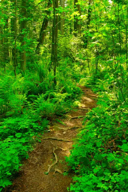
The Art Loeb Trail is one of the most iconic and demanding long-distance paths in the Eastern United States, stretching 48.1 kilometres through the heart of the Pisgah National Forest in North Carolina. Unlike many trails that follow the gentle contours of valley floors or the winding paths of riverbeds, the Art Loeb is a "ridge-runner." It stays high, traversing the peaks and saddles of the spectacular Blue Ridge Mountains, offering hikers a relentless series of ascents and descents that test both physical endurance and navigational skill. From the lush, rhododendron-choked forests of the Davidson River valley to the windswept, alpine-like "balds" of the Black Balsam area, and finally to the daunting slopes of Cold Mountain, this trail provides a comprehensive tour of the Southern Appalachian landscape. It is a journey of profound ecological diversity, where one can transition from temperate rainforest conditions to sub-alpine spruce-fir forests within a single day's march.
- Distance: 48.1 km point-to-point
- Duration: 2–4 days
- Season: April–May (wildflowers) and September–October (autumn foliage)
- Elevation Gain: 2,471 m
- Highest Point: Black Balsam Knob (1,893 m)
- Difficulty: Challenging (rugged terrain, significant elevation changes, and limited water)
- Direction: Can be hiked in either direction, though South-to-North is traditional
Overview
The Art Loeb Trail is a point-to-point traverse that serves as a microcosm of the Appalachian mountain experience. Located near the town of Brevard, North Carolina, the trail is named after an activist from the Carolina Mountain Club who was instrumental in the conservation of these lands. The route is divided into four distinct sections, each with its own character and challenges. The southern section begins at the Davidson River, climbing steadily through hardwood forests. The middle-southern section involves the crossing of Pilot Mountain, a strenuous climb that rewards hikers with exceptional views. The middle-northern section is perhaps the most famous, crossing the high-altitude balds—treeless mountain tops like Black Balsam Knob and Tennent Mountain—where 360-degree panoramas stretch across the rolling blue waves of the Appalachian range. The final northern section plunges into the Shining Rock Wilderness, a federally protected area where the trail becomes narrower, more rugged, and intentionally devoid of blazes, before concluding near the base of the legendary Cold Mountain.
What sets the Art Loeb Trail apart from its peers is its uncompromising commitment to the ridgeline. Hikers will find themselves constantly ascending "PUDs" (Pointless Ups and Downs), as the trail rarely skirts a peak if it can go over it. This results in a total elevation gain of nearly 2,500 metres, a staggering figure for a trail under 50 kilometres. The terrain is often technical, featuring tangled webs of rhododendron roots, slick metamorphic rock, and deeply eroded gullies that require careful footwork. Furthermore, because the trail stays high on the ridges, water is a precious and scarce commodity. Planning your journey around the few reliable springs is the primary logistical challenge of the trek.
The experience of the Art Loeb is one of constant transformation. In the morning, you may be shrouded in the "smoke" of the Great Smoky Mountains—a thick, ethereal mist caused by the transpiration of the dense forest. By midday, you might be standing on a sun-drenched bald, buffeted by high-altitude winds, looking out over a landscape that appears unchanged for millennia. By evening, you could be camped in a dark, fragrant grove of Fraser firs, listening to the wind howl through the needles. It is a trail that demands respect, preparation, and a high level of fitness, but the reward is an intimate connection with one of the oldest mountain ranges on Earth.
History and Cultural Context
The history of the Art Loeb Trail is inextricably linked to the history of American conservation and the specific legacy of the Pisgah National Forest. Long before European settlers arrived, these mountains were the ancestral home of the Cherokee People (Tsalagi). The ridges that the Art Loeb now follows were likely used as hunting grounds and travel corridors. The Cherokee held a deep spiritual connection to peaks like Cold Mountain and the Shining Rock ledges, which they called "the white mountain" due to the brilliant outcroppings of monocrystalline quartz that crown the summit.
In the late 19th and early 20th centuries, the landscape was dramatically altered by the logging industry. Much of the Pisgah forest was part of the vast Biltmore Estate owned by George Vanderbilt. Vanderbilt, realising the ecological toll of unregulated logging, hired Gifford Pinchot and later Carl A. Schenck to manage his forests. This led to the birth of professional forestry in America and the creation of the "Cradle of Forestry," located just a few kilometres from the trail's southern terminus. When the federal government purchased the land to create the Pisgah National Forest in 1916, it was one of the first national forests established in the Eastern United States.
The trail itself is named in honour of Arthur J. Loeb, a dedicated member of the Carolina Mountain Club and a passionate advocate for the protection of the Blue Ridge. Loeb was known for his tireless work in trail maintenance and his efforts to ensure that the public had access to the high peaks. Following his death in 1968, the trail was dedicated in his name, cobbling together various existing paths and new sections to create the continuous 48-kilometre traverse we see today. In the 1960s and 70s, the northern section of the trail was included in the newly designated Shining Rock Wilderness, ensuring that the most pristine and rugged portion of the route would remain protected from mechanised transport and commercial development. Today, the trail stands as a testament to the vision of early conservationists who recognised that the true value of these mountains lay in their wildness and their ability to provide a sanctuary for the human spirit.
Want more background? Read extended notes on history and cultural context → Learn more
Seasonal Highlights and Weather Reality
The Art Loeb Trail is a four-season destination, but the experience varies wildly depending on the month. The "best" times to visit are generally considered the shoulder seasons of spring and autumn, when temperatures are moderate and the visual spectacle is at its peak.
Spring (April to May): This is the season of the "green-up." As you climb from the Davidson River, you can watch the forest wake up in real-time. The lower elevations are carpeted in spring ephemerals—trilliums, violets, and trout lilies. By May, the rhododendrons and mountain laurels begin their spectacular bloom, turning the trail into a tunnel of pink and white blossoms. However, spring weather is notoriously fickle; heavy rain and sudden thunderstorms are common, and the higher elevations can still experience freezing temperatures and even late-season snow.
Summer (June to August): Summer in the Blue Ridge is characterised by high humidity and the "haze" that gives the mountains their name. While the forest canopy provides shade in the lower sections, the high balds are completely exposed to the sun, making heat exhaustion a real risk. Afternoon thunderstorms are a daily occurrence; these are often violent and accompanied by dangerous lightning. For hikers on the exposed ridges of Black Balsam or Tennent Mountain, these storms require immediate descent to safer, lower ground. Water sources are also at their lowest during the late summer months.
Autumn (September to October): This is arguably the most popular time to hike the Art Loeb. The humidity drops, the air becomes crisp and clear, and the deciduous forests erupt in a riot of colour—fiery reds from the maples, deep oranges from the oaks, and brilliant yellows from the birches. The views from the balds are never better than on a clear October day. However, this is also the busiest time on the trail, and campsites can become crowded.
Winter (November to March): Winter hiking on the Art Loeb is for the experienced and well-equipped. While the lack of leaves opens up "window views" through the trees, the conditions can be brutal. The trail is often covered in ice and snow, and temperatures on the high ridges can drop well below -10 degrees Celsius, with wind chills making it feel much colder. The Blue Ridge Parkway, which provides access to the middle sections of the trail, is frequently closed in winter due to ice, making logistics significantly more difficult.
Recommended Itinerary
3-Day Art Loeb Trail Itinerary (South to North)
Day 1: Davidson River Campground to Deep Gap (near Pilot Mountain)
- Distance: 15.2 km
- Elevation gain: 980 m
- Time: 6–8 hours
- Start at the southern terminus near the Davidson River Campground (Brevard)
- The trail begins with a steady, relentless climb up Shut-in Ridge
- Pass through dense hardwood forests of oak, hickory, and poplar
- Traverse the shoulder of Cedar Rock Mountain, offering the first glimpses of the surrounding peaks
- The climb up Pilot Mountain is the day's highlight—a steep, technical ascent to 1,540 m
- Descend into Deep Gap, a popular and sheltered camping area
- Water is usually available at a spring located about 200 metres down a side trail from the gap
- This is a physically demanding first day that sets the tone for the rest of the journey
Day 2: Deep Gap to Ivestor Gap / Black Balsam Area
- Distance: 17.5 km
- Elevation gain: 850 m
- Time: 7–9 hours
- Leave Deep Gap and continue the ridge-running theme over several smaller peaks
- Cross the Blue Ridge Parkway at Wagon Road Gap (be careful of traffic)
- Enter the high-altitude section of the trail as you climb toward Silvermine Bald
- The landscape transforms into sub-alpine spruce-fir forest, smelling strongly of balsam
- Reach the "Balds"—Black Balsam Knob (1,893 m) and Tennent Mountain (1,847 m)
- These are the most spectacular kilometres of the trail, with wide-open views in every direction
- Descend to Ivestor Gap, the gateway to the Shining Rock Wilderness
- Camp in the vicinity of Ivestor Gap or Black Balsam (note: bear canisters are mandatory here)
- Water can be found at a reliable pipe spring near the Ivestor Gap trail junction
Day 3: Ivestor Gap to Daniel Boone Boy Scout Camp (via Cold Mountain)
- Distance: 15.4 km
- Elevation: 641 m gain, 1,200 m descent
- Time: 7–9 hours
- Enter the Shining Rock Wilderness; the trail is no longer blazed, so navigation is critical
- Pass the Shining Rock ledges—massive outcroppings of white quartz
- Navigate the "Narrows," a rugged and narrow section of ridge with steep drop-offs
- Reach the junction for Cold Mountain; the 2.4 km (one-way) spur trail to the summit is highly recommended
- The summit of Cold Mountain (1,838 m) offers a sense of isolation and grandeur
- Begin the long, punishing descent toward the northern terminus
- The trail drops nearly 1,000 metres in the final 6 kilometres, testing knees and ankles
- Finish at the Daniel Boone Boy Scout Camp trailhead
- Arrange for a pre-booked shuttle or a second vehicle to return to Brevard
Important Notes:
- The trail is point-to-point; logistics for transport between trailheads must be organised in advance
- Water is scarce on the ridges; always carry at least 3 litres and refill at every opportunity
- The Shining Rock Wilderness section has no trail markings (blazes); a map and compass/GPS are essential
- Bear canisters are legally required for overnight stays in the Shining Rock Wilderness and surrounding areas
- Weather on the balds can change in minutes; always have rain gear accessible
- Cell service is extremely spotty and should not be relied upon for navigation or emergencies
Planning and Bookings
Book Your Trip
Everything you need to plan your journey
Accommodation
Find places to stay near Brevard
Flights
Search flights to Brevard
Essential Preparation
The Art Loeb Trail requires significant physical preparation and logistical planning. Because it is a point-to-point trail, you must decide whether to use two vehicles or hire a local shuttle service. Most hikers prefer to park their car at the northern terminus (Daniel Boone Camp) and take a shuttle to the southern end (Davidson River), allowing them to walk back to their vehicle. Several private shuttle operators in Brevard and Asheville cater specifically to Art Loeb hikers.
Fitness is a major factor. The trail's "ridge-runner" nature means you are rarely on flat ground. Training with a weighted pack on hilly terrain is highly recommended. Additionally, the town of Brevard serves as the primary base. It is a vibrant "outdoor town" with multiple gear shops, supermarkets, and breweries. It is wise to spend a night in Brevard before starting to finalise gear and check the latest weather reports at the Pisgah Ranger Station.
Trail Accommodation
There are no formal huts, lodges, or reservable campsites on the Art Loeb Trail. Accommodation is entirely based on dispersed wilderness camping.
Camping Details:
- Dispersed camping is permitted throughout most of the Pisgah National Forest
- Established "stealth" sites (cleared areas with existing fire rings) are found at major gaps like Deep Gap, Butter Gap, and Ivestor Gap
- In the Shining Rock Wilderness, you must camp at least 15 metres from trails and water sources
- No fees are required for camping, and no reservations are possible—it is first-come, first-served
- Facilities: None. There are no toilets, shelters, or picnic tables on the trail
- Seasonal Availability: Open year-round, though winter camping requires specialised cold-weather gear
What is NOT Provided:
- No treated water (all water must be filtered from springs)
- No trash cans (Pack it in, Pack it out)
- No fire wood (only downed wood may be used, though fires are discouraged and often banned in the Wilderness area)
- No emergency communication (no cell towers on the ridges)
Required Gear
- Hiking boots - Sturdy, waterproof, and well-broken-in. The trail is exceptionally rocky and root-heavy
- Navigation - A high-quality topographic map (Pisgah Ranger District map) and a reliable GPS or compass. The Wilderness section is unblazed
- Bear Canister - A hard-sided, approved bear-resistant container is mandatory for all overnight stays in the Shining Rock Wilderness and Black Balsam area
- Waterproof Jacket - High-quality breathable waterproofs are essential for sudden Appalachian downpours
- Backpacking Pack - 50–65L capacity with a comfortable suspension system to handle the heavy elevation changes
- Shelter - A lightweight tent or tarp system capable of withstanding high winds on the ridges
- Sleeping System - A 3-season sleeping bag (rated to at least 0°C) and an insulated sleeping pad
- First Aid Kit - Including blister treatment, antiseptic, and any personal medications
- Emergency Whistle and Signal Mirror - For use in the rugged Wilderness sections
What to Bring
- Water Treatment - A reliable filter (Sawyer Squeeze or Katadyn BeFree) or chemical purification tablets. Stream water is untreated
- Food - High-calorie, lightweight meals for 3–4 days. There are no resupply points on the trail
- Cooking System - A lightweight canister stove (Jetboil or MSR Pocket Rocket) and fuel. Open fires are often restricted
- Water Storage - Capacity to carry at least 3–4 litres of water, as stretches between springs can be long
- Clothing Layers - Merino wool or synthetic base layers, a fleece or down mid-layer, and extra socks (keep one pair dry for sleeping)
- Sun Protection - Hat, sunglasses, and sunscreen, especially for the exposed sections on the balds
- Trowel and Toilet Paper - For proper waste disposal (LNT principles)
- Power Bank - To keep GPS devices or phones (for offline maps) charged
- Headlamp - With extra batteries, as the forest canopy makes the trail dark early
Permits
One of the appeals of the Art Loeb Trail is the lack of a formal permit system for individual hikers or small groups. Unlike many of the "Great Walks" or National Park trails, you do not need to book a start date or pay for a permit to hike the Art Loeb.
Current Regulations:
- Individual Hikers: No permit required for day use or overnight camping
- Group Size: In the Shining Rock Wilderness, group size is strictly limited to 10 people to minimise impact on the fragile ecosystem
- Commercial Groups: Any organised group charging a fee (guides, summer camps) must obtain a Special Use Permit from the US Forest Service
- Bear Canisters: While not a "permit," the use of an approved bear canister is a legal requirement. Failure to use one can result in a significant fine from Forest Service rangers
Parking and Access:
- Davidson River (South): Parking is available at the Art Loeb trailhead near the campground. There is currently no fee for parking here
- Daniel Boone Camp (North): This is private property (Boy Scout Camp). Hikers are permitted to park in a designated gravel lot just outside the camp gates. Be respectful and do not enter the camp facilities
- Black Balsam/Ivestor Gap (Middle): Accessible via the Blue Ridge Parkway. Parking here is extremely limited on weekends and often overflows. Do not park on the grass, as rangers frequently issue tickets
Other Activities in the Area
The Pisgah National Forest and the surrounding Transylvania County are known as the "Land of Waterfalls." Consider these activities to complement your hike:
- Looking Glass Falls: One of the most photographed waterfalls in the Eastern US, located just a short drive from the southern trailhead. It is easily accessible from the roadside.
- Sliding Rock: A natural 18-metre water slide that ends in a deep, cold pool. It is a popular spot to cool off after a strenuous hike during the summer months.
- The Cradle of Forestry: Visit the site of the first forestry school in America. It features historic buildings, easy walking trails, and an excellent discovery centre.
- Mountain Biking: Brevard is a world-class mountain biking destination. Trails in the nearby DuPont State Recreational Forest or the "Black Mountain" area of Pisgah offer everything from flowy paths to technical descents.
- Fly Fishing: The Davidson River is a premier trout stream. Many local outfitters in Brevard offer guided trips and gear rentals.
- Asheville: Located 45 minutes away, this city offers a vibrant arts scene, the historic Biltmore Estate, and more craft breweries per capita than almost anywhere else in the country.
Safety and Conditions
Pre-Departure Checks:
- Check the National Weather Service forecast specifically for "Pisgah Forest, NC" and "Black Balsam Knob"
- Visit the Pisgah Ranger Station (on US-276) to ask about recent trail conditions, bear activity, or water source reliability
- Ensure your bear canister is properly functioning and that you know how to store it away from your tent
- Leave a detailed itinerary with a friend or family member, including your expected exit time and vehicle details
Navigation Hazards: The Art Loeb Trail is notoriously difficult to follow in certain sections. In the Shining Rock Wilderness, there are no blazes (paint marks on trees). The trail often braids into multiple "social paths" created by hikers looking for campsites or viewpoints. It is very easy to take a wrong turn, especially in foggy conditions. Always carry a physical map and compass, and know how to use them. Do not rely solely on a smartphone, as batteries fail and cold temperatures can cause rapid power loss.
Weather Extremes: The high balds (Black Balsam, Tennent Mountain) are extremely exposed. If you see dark clouds or hear thunder, you must leave the ridgeline immediately. Lightning strikes are a genuine threat in the summer. In winter and shoulder seasons, hypothermia is the primary danger. The combination of wet clothing, high winds, and temperatures around 0–5 degrees Celsius is the most dangerous environment for hikers. Always carry a high-quality rain shell and an insulating layer, even if the forecast looks clear.
Water Scarcity: Because the trail follows the highest ground, you will not cross many streams. The few springs that exist (Deep Gap, Butter Gap, Ivestor Gap) can dry up during periods of low rainfall. Never pass a reliable water source without topping off your bottles. Aim to carry at least 3 litres of capacity.
Wildlife: Black bears are active throughout the Pisgah National Forest. While they are generally shy, they have become habituated to human food in the Black Balsam and Shining Rock areas. This is why bear canisters are mandatory. Never keep food, trash, or scented items (toothpaste, lip balm) in your tent. Additionally, timber rattlesnakes and copperheads are present in the lower elevations; watch your step on rocky outcrops and near fallen logs.
Side Trips and Points of Interest
Cold Mountain: Immortalised by Charles Frazier’s novel and the subsequent film, Cold Mountain is the northern anchor of the trail. The summit is reached via a 2.4 km spur trail from Deep Gap (the northern Deep Gap, not to be confused with the southern one). The climb is steep, but the summit offers a profound sense of solitude and a view that encompasses the entire Shining Rock Wilderness. It is the perfect place to reflect on the journey before the final descent.
Shining Rock Ledges: These massive outcrops of white quartz give the wilderness its name. The rocks are brilliant in the sunlight and provide a stark, beautiful contrast to the surrounding green forest. They are a popular spot for lunch and offer excellent views toward the Great Smoky Mountains to the west.
Black Balsam Knob and Tennent Mountain: These are the "crown jewels" of the Art Loeb. Unlike the forested peaks common in the Appalachians, these summits are covered in grasses, wildflowers, and low-growing blueberries. Walking across these balds feels more like being in the Scottish Highlands or the Alps than the Southern US. The 360-degree views are arguably the best in North Carolina.
The Narrows: Located between Shining Rock and Cold Mountain, this section of the trail follows a very thin ridge. In some places, the trail is only a metre wide with steep drops on either side. It requires careful footwork but provides some of the most "alpine" feeling terrain on the entire East Coast.
Pilot Mountain: Not to be confused with the Pilot Mountain near Winston-Salem, this peak offers a rugged, rocky summit with views back toward the Davidson River valley. The ascent from the south is one of the steepest sustained climbs on the trail.
Leave No Trace
The Art Loeb Trail, particularly the Shining Rock Wilderness, is under significant environmental pressure due to its popularity. The high-altitude balds are home to rare and fragile plant species that can be destroyed by a single misplaced footstep. As a hiker, you are a steward of this ancient landscape.
Your responsibility as a walker:
- Stay on the established trail tread, even when it is muddy or rocky. Walking around mud puddles widens the trail and destroys vegetation
- Camp only in established sites. Do not create new fire rings or clear new areas for tents
- Respect the "No Trace" ethos of the Wilderness area—do not build structures, cairns, or leave any markings
- Pack out all trash, including "organic" waste like orange peels or apple cores, which do not decompose quickly in this environment and attract bears
- Dispose of human waste properly: dig a "cathole" at least 15–20 cm deep and at least 60 metres from any water source or trail
- Keep groups small (under 10) to reduce the social and physical impact on the trail
- Avoid using fire in the high balds; the thin soils and high winds make fire both damaging and dangerous. Use a stove for all cooking
The goal is to leave the trail exactly as you found it, ensuring that the "white mountain" and the "blue ridges" remain pristine for the next generation of explorers.