Arctic Circle Trail - Greenland's Premier Wilderness Thru-Hike
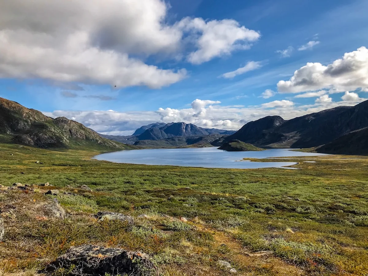
The Arctic Circle Trail (ACT) is one of the most remote and spectacular long-distance hiking routes in the Northern Hemisphere. Stretching approximately 160 kilometres across the vast, treeless tundra of Western Greenland, the trail connects the inland transport hub of Kangerlussuaq with the coastal town of Sisimiut. This is a journey through a landscape of profound silence and immense scale, where the only sounds are the wind across the dwarf birch and the occasional cry of a raven. Traversing the largest ice-free region of Greenland, the trail crosses a mosaic of low-lying valleys, crystalline lakes, and rugged granite hills, all situated roughly 40 to 50 kilometres north of the Arctic Circle. This is not merely a hike; it is an immersion into a prehistoric world where nature remains largely untamed and human presence is fleeting.
The route offers a unique transition in geology and ecology. Starting near the edge of the Greenland Ice Sheet (Sermersuaq), walkers move westward through increasingly mountainous terrain until reaching the jagged peaks and deep fjords of the Davis Strait. Along the way, hikers may encounter muskoxen, reindeer (caribou), Arctic foxes, and mountain hares. With no permanent settlements between the start and finish, and no mobile phone reception for the vast majority of the trek, the Arctic Circle Trail demands total self-sufficiency and a high degree of mental resilience. It is a world-class challenge for those seeking to disconnect from modern life and reconnect with the raw elements of the Arctic environment.
- Distance: 160.0 km one-way
- Duration: 7–10 days
- Season: Mid-June to mid-September (best for hiking); March–April (for dog sledding/skiing)
- Elevation Gain: Approximately 2,500 m total
- Highest Point: Approximately 450 m (near Innajuattoq)
- Difficulty: Challenging (due to remoteness, terrain, and self-sufficiency requirements)
- Direction: Usually walked East to West (Kangerlussuaq to Sisimiut), but can be reversed
- Accommodation: 8–9 basic wooden huts and unlimited wild camping
Overview
The Arctic Circle Trail is defined by its isolation. Unlike many European or North American long-distance trails, there are no resupply points, no mountain cafés, and no emergency shelters with wardens. Once you leave Kangerlussuaq, you must carry every gram of food and equipment required for the duration of your journey. The trail follows a natural corridor that has been used by Inuit hunters for millennia, yet it remains remarkably pristine. The terrain is a mix of soft tundra, boggy marshland, rocky ridges, and sandy lakeside beaches. While the elevation gains are not extreme by alpine standards, the "Arctic hummocks"—small, uneven mounds of vegetation—and the frequent necessity of navigating around or through water make the physical exertion higher than the statistics might suggest.
The experience of the ACT changes dramatically depending on the month. In late June and July, the region experiences the midnight sun, where the sun never sets, providing 24 hours of daylight for trekking. However, this period also coincides with the peak of the Arctic mosquito and blackfly season, which can be a significant psychological challenge. By late August and September, the insects disappear, the tundra turns a brilliant palette of ochre, gold, and crimson, and the first Northern Lights (Aurora Borealis) begin to dance across the darkening night sky. The weather is notoriously fickle; even in mid-summer, temperatures can plummet toward freezing, and heavy rain or even unseasonal snow can occur.
Navigation is generally straightforward, as the trail is marked by stone cairns (cairns with a painted red semi-circle representing the Greenlandic flag). However, in poor visibility or on the more remote sections, these markers can be difficult to spot, requiring hikers to be proficient with a map, compass, or GPS. The reward for this effort is a sense of solitude that is increasingly rare in the modern world. It is common to walk for days without seeing another human being, sharing the landscape only with the ancient muskoxen that roam the valleys. The Arctic Circle Trail is a masterclass in minimalist living and a profound test of one's relationship with the wilderness.
History and Cultural Context
The land through which the Arctic Circle Trail passes is part of the Aasivissuit – Nipisat UNESCO World Heritage site, recognised for its "Cultural Hunting Greens" that have been used by humans for over 4,500 years. This region represents the largest and most complete record of human occupation in the Arctic, spanning the Saqqaq, Dorset, and Thule cultures, as well as the modern Inuit. For thousands of years, these nomadic peoples followed the seasonal migrations of caribou (reindeer) from the coast to the inland grazing grounds near the ice sheet. Along the trail, observant hikers may still find "inuksuit" (ancient stone landmarks), tent rings, and meat caches that tell the story of a people who mastered survival in one of the Earth's harshest climates.
The modern hiking trail was formalised in the late 1990s to encourage sustainable tourism and provide a structured route for international trekkers. Before this, the path existed only as a series of disconnected hunting tracks. The development of the hut system—mostly small, wooden structures built by the local municipalities of Qeqqata—transformed the route into a viable thru-hike. These huts are often located near traditional hunting camps, maintaining a link between the modern recreational use of the land and its historical purpose as a source of life and sustenance for the Greenlandic people.
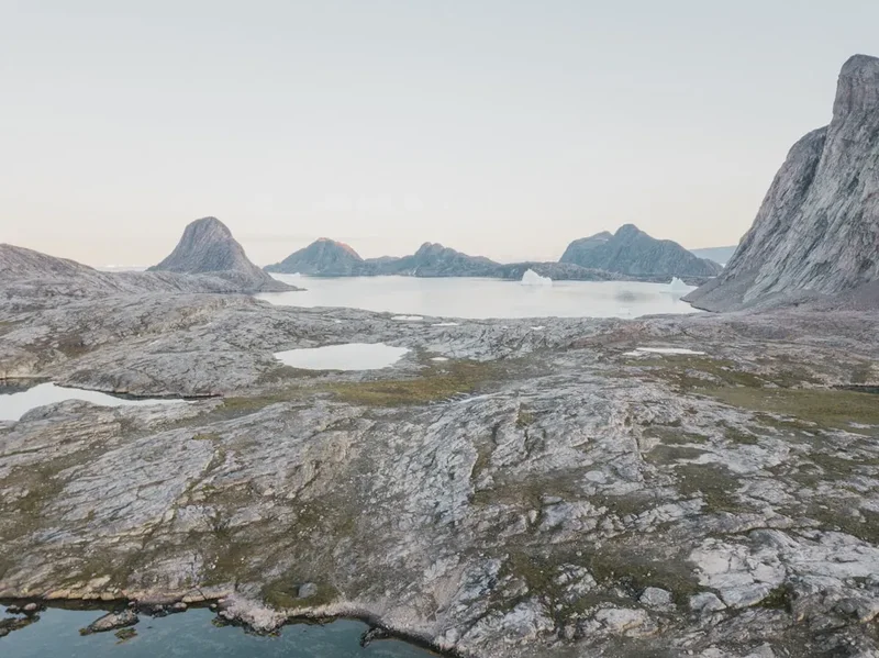
Sisimiut, the trail's western terminus, is Greenland's second-largest town and has been inhabited for four millennia. It remains a hub for traditional activities like dog sledding and fishing, while Kangerlussuaq, the eastern start point, began as a US military base (Sondrestrom Air Base) during World War II. The contrast between the military-industrial history of Kangerlussuaq and the ancient, sea-focussed culture of Sisimiut provides a fascinating cultural bookend to the natural wonders of the trail itself. Walking the ACT is, in many ways, a journey through time, tracing the footsteps of the hunters who first explored these valleys when the world was much younger.
Want more background? Read extended notes on history and cultural context → Learn more
Seasonal Highlights and Weather Reality
The window for hiking the Arctic Circle Trail is relatively short, dictated by the rapid onset of the Arctic winter and the spring melt. Outside of the summer months, the trail is the domain of dog sleds and snowmobiles, and the huts are used primarily by local hunters.
Early Summer (Mid-June to Mid-July): This is the time of the midnight sun. The landscape is incredibly lush, and water is abundant. However, the ground is often saturated from the recent snowmelt, leading to very boggy conditions and high river levels. This is also the peak season for mosquitoes. Hikers during this period must be prepared for constant insect activity and should carry high-quality head nets and repellent.
High Summer (Late July to Mid-August): This is the most popular time to hike. The bogs begin to dry out, river crossings become easier, and the mosquito population starts to decline. Temperatures are at their warmest, often reaching 15°C to 20°C during the day, though nights remain cool. The berries (crowberries and blueberries) begin to ripen across the tundra, providing a welcome supplement to dehydrated trail meals.
Autumn (Late August to Mid-September): Many experienced hikers consider this the best time for the ACT. The insects are gone, and the tundra turns spectacular shades of red and orange. The nights become dark enough to see the Northern Lights, and the air is crisp and clear. However, the risk of frost and early snow increases significantly, and daylight hours diminish rapidly. By mid-September, many of the smaller streams may begin to freeze, and the weather can become much more volatile.
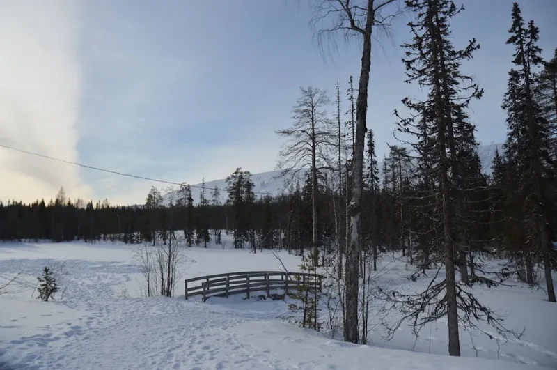
Winter and Spring (October to May): During this time, the trail is an extreme Arctic environment. Temperatures can drop to -40°C. While the route can be traversed on skis or by dog sled, it requires specialised polar equipment and expertise. The huts remain open but are unheated, serving as basic survival shelters rather than comfortable accommodation.
Recommended Itinerary
9-Day Arctic Circle Trail Itinerary (East to West)
Day 1: Kangerlussuaq to Hundesø
- Distance: 20 km
- Elevation gain: 200 m
- Time: 5–7 hours
- Start at Kangerlussuaq Airport and walk west along the road toward Kelly Ville
- Pass the research station at Kelly Ville and transition onto the marked trail
- The terrain is relatively flat, following a sandy track through low scrub
- Arrive at Hundesø, a collection of small huts and a repurposed caravan
- First night in the wilderness; good opportunities for spotting muskoxen near the lake
Day 2: Hundesø to Katiffik
- Distance: 20 km
- Elevation gain: 250 m
- Time: 6–8 hours
- The trail climbs over several ridges, offering views back toward the ice sheet
- Traverse through valleys filled with dwarf birch and willow
- Pass several small lakes before descending toward the large lake of Amitsorsuaq
- Arrive at Katiffik hut, situated at the eastern end of the lake
- The hut is small (6–8 people) and sits in a beautiful, sheltered location
Day 3: Katiffik to Canoe Centre
- Distance: 20 km
- Elevation gain: Minimal (flat lakeside walking)
- Time: 5–7 hours
- Follow the northern shore of Lake Amitsorsuaq for the entire day
- The terrain is mostly flat but can be rocky or sandy in places
- If canoes are available at Katiffik, hikers can paddle the 20 km to the next hut (check condition of canoes and paddles first)
- Arrive at the Canoe Centre, the largest hut on the trail (20+ bunks)
- Excellent spot for a mid-trip wash in the lake or a social evening with other hikers
Day 4: Canoe Centre to Ikkattooq
- Distance: 22 km
- Elevation gain: 350 m
- Time: 7–9 hours
- Leave the lake and climb into a more rugged, upland landscape
- The trail crosses several high plateaus with expansive views of the surrounding mountains
- Pass through areas of "Arctic cotton" and boggy sections
- Arrive at Ikkattooq hut, a small wooden cabin perched on a ridge
- This is one of the most exposed huts; views of the sunset over the mountains are spectacular
Day 5: Ikkattooq to Eqalugaarniarfik
- Distance: 17 km
- Elevation gain: 200 m (significant descent)
- Time: 5–7 hours
- Descend from the highlands into a broad, lush valley
- The trail follows a river system with several easy stream crossings
- Pass through some of the tallest vegetation on the trail (willow thickets up to 2 metres high)
- Arrive at Eqalugaarniarfik hut, located near a major river junction
- Good fishing opportunities in the nearby river (Arctic char)
Day 6: Eqalugaarniarfik to Innajuattoq
- Distance: 19 km
- Elevation gain: 450 m
- Time: 7–9 hours
- The day begins with the crossing of the Itinneq River (the largest on the trail)
- A bridge is usually available, but in high melt years, a wade may be required
- A long, steady climb follows, leading to the highest point of the trail
- Pass through a dramatic mountain pass surrounded by jagged peaks
- Arrive at Innajuattoq, which consists of two huts (one older, one newer) by a large lake
Day 7: Innajuattoq to Nerumaq
- Distance: 17 km
- Elevation gain: 150 m (mostly descent)
- Time: 5–7 hours
- Follow the lake shore before descending into a narrow, winding valley
- The scenery becomes more "alpine" as you approach the coast
- The trail can be very boggy in the valley floor; expect wet feet
- Arrive at Nerumaq hut, a small cabin tucked into the valley
- The surrounding cliffs are home to many ravens and birds of prey
Day 8: Nerumaq to Kangerluarsuk Tulleq
- Distance: 17 km
- Elevation gain: 300 m
- Time: 6–8 hours
- Continue down the valley toward the first sight of the sea (the fjord)
- The trail climbs over a final significant ridge before descending to the fjord head
- Pass through areas of spectacular rock formations and scree slopes
- Arrive at Kangerluarsuk Tulleq, which has two huts (the "Syd" and "Nord" huts)
- The smell of salt air marks the transition to the coastal environment
Day 9: Kangerluarsuk Tulleq to Sisimiut
- Distance: 22 km
- Elevation gain: 400 m
- Time: 7–9 hours
- A long final day climbing over the mountain range that separates the fjord from Sisimiut
- Pass beneath the towering peak of Nasaasaaq
- The trail eventually joins a ski lift track and a gravel road leading into town
- Finish at the harbour in Sisimiut
- Celebrate with a hot shower and a meal at a local restaurant
Important Notes:
- Distances are approximate and can vary based on GPS tracking and route choices
- The itinerary can be compressed into 7 days by fit hikers or extended to 11–12 days for a more relaxed pace
- Water is available from lakes and streams every few kilometres; treatment is generally not required but recommended near huts
- There are no shops or services between Kangerlussuaq and Sisimiut
- Always sign the guest books in the huts for safety and statistical purposes
Planning and Bookings
Book Your Trip
Everything you need to plan your journey
Accommodation
Find places to stay near Kangerlussuaq
Flights
Search flights to Kangerlussuaq
Essential Preparation
The Arctic Circle Trail requires meticulous planning because there is zero opportunity to purchase supplies once you begin. Your preparation should start at least six months in advance, particularly regarding flight bookings. Most hikers fly into Kangerlussuaq (SFJ) via Copenhagen (Denmark) or Reykjavik (Iceland) with Air Greenland or Icelandair. Because Kangerlussuaq is the primary international hub for Greenland, flights are frequent but can be expensive.
Physical fitness is crucial. While the trail is not technically difficult (no rock climbing or glacier travel), you will be carrying a heavy pack (typically 15–25 kg) for 160 kilometres over uneven, often boggy ground. Training should focus on long-distance walking with a weighted pack. Additionally, you must be comfortable with basic navigation and Arctic weather safety. There is no mountain rescue service in the traditional sense; any evacuation would be by helicopter and extremely costly, making personal locator beacons (PLBs) or satellite messengers (like Garmin inReach) essential.
Trail Accommodation
Accommodation on the Arctic Circle Trail is a mix of public huts and wild camping. The huts are maintained by the local municipality and are free to use on a first-come, first-served basis. They are basic, unheated wooden structures designed to provide shelter from the elements.
Hut Facilities:
- Wooden sleeping platforms (no mattresses; sleeping mats required)
- Small table and benches
- Basic wood-burning or oil stove (rarely functional and no fuel provided; do not rely on these for heat)
- Guest book for registration
- Basic pit toilet (located in a separate small building nearby)
- Solar lighting (available in some newer huts, but unreliable)
What Huts Don't Provide:
- Food, fuel, or cooking equipment
- Bedding, pillows, or blankets
- Running water or electricity
- Trash collection (you MUST pack out all rubbish)
Camping: Wild camping is permitted anywhere along the trail. Most hikers carry a tent even if they plan to stay in huts, as huts can be full or you may not reach your intended destination due to weather or fatigue. A sturdy, wind-resistant 3-season tent is mandatory.
Required Gear
- Footwear: High-quality, waterproof hiking boots with good ankle support. The terrain is a mix of sharp rocks and deep bogs; boots will get wet, so choose pairs that dry relatively quickly or use waterproof socks (SealSkinz).
- Clothing: A layering system is essential. Include merino wool base layers, a fleece or down mid-layer, and a high-quality Gore-Tex shell (jacket and trousers). Do not bring cotton clothing.
- Backpack: A 60–75 litre pack with a comfortable harness and a waterproof rain cover.
- Sleeping System: A sleeping bag rated to at least -5°C (even in summer) and a high-R-value sleeping mat for insulation from the cold ground or wooden hut platforms.
- Navigation: 1:100,000 scale maps of the trail (available in Kangerlussuaq or online), a compass, and a GPS device with spare batteries.
- Safety: A Satellite Messenger (Garmin inReach or Zoleo) or a PLB. A basic first aid kit including blister care (Compeed), antiseptic, and painkillers.
- Insect Protection: A fine-mesh head net and high-strength repellent (DEET or Picaridin). This is non-negotiable for June and July.
What to Bring
- Food: Lightweight, high-calorie dehydrated meals for the entire duration, plus two days of emergency rations. Porridge, nuts, chocolate, and dried fruit are trail staples.
- Stove and Fuel: A lightweight camping stove (Jetboil, MSR PocketRocket, or Trangia). Note: You cannot fly with gas canisters. You must purchase threaded (Lindal valve) canisters or methylated spirits in Kangerlussuaq at the Pilersuisoq supermarket or the local outfitter.
- Water Treatment: While Greenlandic water is generally very pure, a lightweight filter (Sawyer Squeeze) or chlorine dioxide tablets are recommended, especially when collecting water near huts.
- Personal Hygiene: Biodegradable soap, trowel for waste (if not near a hut), toilet paper, and hand sanitiser.
- Sun Protection: Sunglasses (essential for snow patches and long daylight), sunscreen, and a lip balm with SPF.
- Repair Kit: Duct tape, needle and thread, and a multi-tool.
Permits
One of the great appeals of the Arctic Circle Trail is the lack of bureaucracy. Currently, there are no permits required to hike the trail, and there are no fees for using the huts. The trail is open to everyone at all times.
Registration and Safety: While no formal permit is needed, it is highly recommended (and considered best practice) to register your plans. You can do this at the Arctic Circle Business office in Kangerlussuaq or Sisimiut. More importantly, you should leave your itinerary with a reliable contact at home and sign the guest books in every hut you pass. This provides a "paper trail" for search and rescue teams in the event of an emergency.
Fishing Licences: If you plan to fish for Arctic char in the rivers or lakes, you must purchase a Greenlandic fishing licence. These can be bought online or at the post office/supermarket in Kangerlussuaq or Sisimiut. The cost is approximately 75 DKK (approx. €10) for a 24-hour licence or 200 DKK for a weekly licence.
Insurance: While not a permit, specialised travel insurance that covers "search and rescue" and "medevac" in remote Arctic regions is mandatory for your own safety. Standard travel insurance often excludes these activities.
Other Activities in the Area
Greenland offers unique experiences that are worth adding to your itinerary before or after the hike:
- Point 660 and the Ice Sheet: From Kangerlussuaq, take a 4x4 tour to Point 660, where you can literally step onto the Greenland Ice Sheet. It is a humbling experience to stand on a sheet of ice that is kilometres thick and thousands of years old.
- Russell Glacier: A spectacular wall of ice rising 60 metres from the valley floor. You can hike to the edge of the glacier from Kangerlussuaq (approx. 25 km) or take a guided tour.
- Muskox Safaris: Kangerlussuaq is home to one of the world's largest populations of muskoxen. Guided tours offer the best chance to see these prehistoric-looking creatures up close.
- Sisimiut Town Tour: Explore the historic colonial quarter of Sisimiut, visit the local museum, and see the whalebone arch at the entrance to the church.
- Boat Trips to Abandoned Settlements: From Sisimiut, you can take boat tours to abandoned settlements like Assaqutaq, providing a glimpse into the changing way of life in Greenland.
- Dog Sledding (Winter/Spring only): If visiting in the shoulder season, Sisimiut is one of the best places in Greenland to experience traditional Inuit dog sledding.
Safety and Conditions
Remote Environment: The ACT is a true wilderness. There is no mobile phone coverage. If you get injured, you must be able to self-rescue or signal for help using a satellite device. Never hike this trail alone unless you are an extremely experienced solo trekker with a satellite communicator.
River Crossings: The Itinneq River is the most significant water obstacle. While a bridge was installed several years ago, it can occasionally be damaged by ice or floods. If you must wade, do so at the widest, shallowest point, unclip your backpack waist belt, and use trekking poles for stability. In early summer, glacial melt can make even small streams surprisingly powerful.
Wildlife: Muskoxen are generally peaceful but can be aggressive if they feel cornered or if you get too close (especially bulls or mothers with calves). Maintain a distance of at least 50–100 metres. Polar bears are extremely rare this far inland and south, but they have been sighted near the coast in Sisimiut. While you do not need a rifle for the ACT, staying vigilant and storing food properly is wise.
Weather: Hypothermia is a genuine risk. Even in summer, a combination of rain, wind, and temperatures near 5°C can be lethal if you are not wearing the correct gear. Always keep a set of dry clothes in a waterproof dry bag inside your pack.
Wildfire Risk: The tundra can become extremely dry in July and August. Wildfires have occurred in recent years, fueled by dry peat and scrub. Be extremely careful with camping stoves, never light campfires, and smoke only in designated areas or near water.
Side Trips and Points of Interest
Sugar Loaf (Kangerlussuaq): A popular half-day hike from Kangerlussuaq before you start the main trail. The summit offers a 360-degree view of the airport, the fjord, and the distant ice sheet. It is an excellent way to test your gear and acclimatise to the Arctic air.
Sarfannguit Cultural Hike: Sarfannguit is the only inhabited settlement near the trail (though not directly on it). It is a traditional fishing village located on an island. Some hikers arrange a boat detour to visit this community to experience modern Greenlandic life. A stunning "Viewpoint" architectural installation by Dorte Mandrup is located here, overlooking the UNESCO landscape.
Nasaasaaq Summit (Sisimiut): For those with energy left at the end of the trail, the climb up Nasaasaaq (784 m) provides the ultimate view of Sisimiut and the coast. The final section involves some scrambling and fixed ropes, so it should only be attempted in good weather.
The Canoe Section: On Lake Amitsorsuaq, the "Canoe Centre" often has several aluminium canoes left by the municipality. If you find one at your end of the lake, you can paddle the 20 km instead of walking. This is a highlight for many, offering a break for the feet and a different perspective on the landscape. You must leave the canoe at the opposite end of the lake for the next hikers.
Leave No Trace
The Arctic ecosystem is incredibly fragile. Vegetation grows very slowly due to the short growing season, and waste takes decades to decompose in the cold, dry climate. As a visitor, you have a moral obligation to leave the trail exactly as you found it.
Key Principles for the ACT:
- Waste Management: Pack out ALL rubbish, including food scraps and cigarette butts. Do not leave "extra" food in the huts; it attracts rodents and usually ends up being thrown away by the next person.
- Human Waste: Use the pit toilets at the huts whenever possible. If you must go between huts, dig a "cathole" at least 15 cm deep and at least 100 metres from any water source. In the Arctic, it is often recommended to burn your toilet paper (carefully!) or pack it out in a sealed bag, as it does not break down in the permafrost.
- Stay on the Trail: Avoid creating new paths, especially in boggy areas. Walking through bogs is better than widening the trail by walking on the edges.
- Respect Wildlife: Observe animals from a distance. Do not feed them, as this habituates them to humans and can lead to their death.
- No Campfires: Wood is non-existent, and the tundra is highly flammable. Use only gas or spirit stoves for cooking.