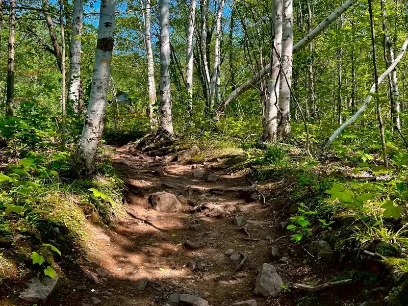
Appalachian Trail - The Legend of the Green Tunnel
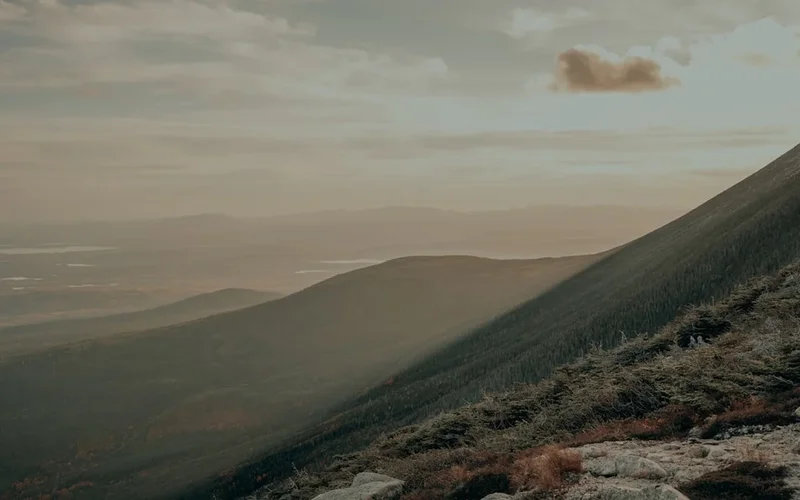
The Appalachian Trail (AT) is perhaps the most iconic long-distance hiking route in the world—a staggering 3,500-kilometre journey that traverses the ancient, rolling spine of the Appalachian Mountains in the Eastern United States. Stretching from the dense forests of Springer Mountain in Georgia to the rugged, granite heights of Mount Katahdin in Maine, the trail passes through 14 states, crossing diverse ecosystems that range from temperate rainforests and high-altitude balds to alpine tundra. Known affectionately as the "Green Tunnel" for its seemingly endless stretches of lush, verdant canopy, the AT is more than just a physical challenge; it is a cultural phenomenon, a rite of passage, and a masterclass in endurance that tests the mental and physical limits of thousands of "thru-hikers" every year.
With a cumulative elevation gain of approximately 157,000 metres—the equivalent of climbing Mount Everest from sea level nearly 18 times—the Appalachian Trail is deceptively difficult. While it lacks the extreme altitudes of the Rocky Mountains or the Sierra Nevada, its relentless "picket fence" profile of steep, short climbs and descents, often over tangled roots and jagged rocks, creates a unique brand of exhaustion. This is a trail defined by its community, its history, and its profound connection to the wilderness that remains nestled within one of the most densely populated regions of North America. Whether attempted as a multi-month thru-hike or a series of section hikes, the AT offers a transformative experience that connects walkers to the deep geological time of the oldest mountains on Earth.
- Distance: 3,500.0 km one-way
- Duration: 5–7 months (thru-hike)
- Season: Spring to Fall (Northbound), Late Summer to Early Winter (Southbound)
- Total Elevation Gain: 157,000 m
- Highest point: Clingmans Dome, Tennessee (2,025 m)
- States traversed: 14 (GA, NC, TN, VA, WV, MD, PA, NJ, NY, CT, MA, VT, NH, ME)
- Direction: Northbound (NOBO), Southbound (SOBO), or Flip-flop
Overview
The Appalachian Trail is a continuous marked footpath that serves as a sanctuary for those seeking to escape the frenetic pace of modern life. It is managed by a unique partnership between the National Park Service, the US Forest Service, the Appalachian Trail Conservancy (ATC), and dozens of local maintaining clubs. This collaborative effort ensures that the trail remains a primitive experience, even as it passes within a few hours' drive of millions of people. The route is marked by its famous white blazes—5-by-15-centimetre vertical rectangles painted on trees and rocks—which guide hikers through some of the most beautiful and ecologically significant landscapes in the United States.
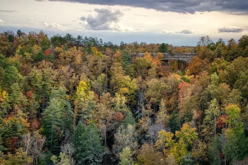
The journey is typically divided into several distinct regions, each with its own character and challenges. The Southern Appalachians are characterised by high ridges, rhododendron tunnels, and the majestic Great Smoky Mountains. The Mid-Atlantic states offer gentler terrain but are notorious for the "Rocksylvania" section, where the trail becomes a punishing field of sharp, ankle-twisting stones. New England provides the dramatic finale, with the steep, exposed peaks of the White Mountains in New Hampshire and the remote, water-rich wilderness of Maine. Throughout the journey, hikers encounter a vibrant "trail culture," including trail towns that offer hospitality, "trail angels" who provide unexpected food and water (known as "trail magic"), and a shared sense of purpose among those attempting the long walk.
Weather is a defining factor of the AT experience. Hikers must contend with the humid heat of the Southern summer, the torrential rains of the Mid-Atlantic, and the potential for snow in the high mountains of the South or the North. The trail is a living classroom of biodiversity, home to black bears, white-tailed deer, moose in the northern reaches, and a vast array of birdlife and wildflowers. To walk the AT is to witness the slow unfolding of the seasons across a continent, from the first spring beauties in Georgia to the fiery autumnal colours of the Maine woods.
Wakahi Guide
Detailed route notes, maps, logistics & tips for the Appalachian Trail (PDF).
History and Cultural Context
The vision for the Appalachian Trail was first proposed in 1921 by Benton MacKaye, a regional planner and philosopher. MacKaye imagined the trail not just as a hiking path, but as the backbone of a series of self-sufficient work camps and communities that would provide an alternative to the industrialised urban environment. While his broader social vision was never fully realised, his idea for a continuous trail caught the imagination of outdoor enthusiasts. The trail's actual construction was largely driven by Myron Avery, a determined lawyer and hiker who coordinated the efforts of hundreds of volunteers to clear and blaze the route. The trail was officially completed in 1937, though it has undergone numerous relocations and improvements in the decades since.
In 1948, Earl Shaffer became the first person to complete a documented thru-hike of the entire trail in a single season, proving that such a feat was possible. Since then, the number of thru-hikers has grown from a handful of pioneers to thousands of individuals each year. The trail's protection was formalised by the National Trails System Act of 1968, which designated the AT as the first National Scenic Trail. This legislation provided the funding and authority to protect the trail corridor from development, ensuring that future generations could enjoy the same wilderness experience as the early explorers.
The land the trail traverses has a much deeper history, having been the ancestral home of numerous Indigenous peoples, including the Cherokee, Monacan, Susquehannock, and Penobscot. For these nations, the mountains were not a wilderness to be conquered, but a sacred landscape that provided sustenance and spiritual connection. Today, the Appalachian Trail Conservancy works to acknowledge this heritage and ensure that the trail remains a place of respect and inclusion for all people. The history of the AT is a testament to the power of a simple idea—that a path through the woods can change lives and preserve the natural world.
Want more background? Read extended notes on history and cultural context → Learn more
Seasonal Highlights and Weather Reality
The timing of an Appalachian Trail hike is critical, as it determines the weather conditions, the social environment, and the state of the flora and fauna. Most thru-hikers choose to go Northbound (NOBO), starting in Georgia in March or April to follow the spring north. This "bubble" of hikers creates a highly social atmosphere but can lead to crowded shelters and campsites. Southbound (SOBO) hikers typically start in Maine in June or July, facing more rugged terrain and black fly season immediately, but enjoying a quieter, more solitary experience as they head toward the southern autumn.
Spring in the South brings the "green-up," where the forest floor is carpeted with wildflowers like trillium and bloodroot. However, it also brings frequent rain and the possibility of late-season snow in the Smokies. Summer on the AT is often characterised by high humidity and heat, particularly in the Mid-Atlantic states, where temperatures can exceed 30 degrees Celsius. This is also the season of spectacular thunderstorms, which can be dangerous on exposed ridges. Autumn is perhaps the most beautiful time on the trail, with the deciduous forests of New England and the Blue Ridge Mountains erupting in vibrant reds, oranges, and yellows. However, hikers must finish before the winter snows close the trail in the high mountains.
Winter hiking on the AT is a serious undertaking reserved for the most experienced and well-equipped adventurers. Many sections of the trail, particularly in the White Mountains and Maine, become treacherous alpine environments requiring crampons, ice axes, and expert navigation skills. Most hikers aim to complete their journey between April and October to avoid the most extreme conditions. Regardless of the season, hikers must be prepared for rapid weather changes; a sunny morning can quickly turn into a freezing, rain-soaked afternoon at higher elevations.
Recommended Itinerary
The Thru-Hiker's Progression (Northbound)
Phase 1: The Southern Highlands (Georgia to Virginia Border)
- Distance: Approximately 750 km
- Key Waypoints: Springer Mountain, Blood Mountain, Nantahala Outdoor Centre, Great Smoky Mountains National Park, Max Patch, Hot Springs, Roan Mountain
- Terrain: Steep, repetitive climbs and descents through dense hardwood forests and over high-altitude "balds" (grassy summits)
- Highlights: The 360-degree views from Max Patch and the stunning rhododendron tunnels of the Roan Highlands
- Challenge: Finding "trail legs" while navigating the frequent spring rains and occasional snow in the Smokies
Phase 2: The Virginia Grind (Damascus to Harpers Ferry)
- Distance: Approximately 880 km
- Key Waypoints: Damascus (Trail Town USA), Grayson Highlands, McAfee Knob, Shenandoah National Park, Harpers Ferry (Psychological Midpoint)
- Terrain: Long, rolling ridges and the famous "Virginia Blues"—a mental challenge where the state seems to never end
- Highlights: Wild ponies in Grayson Highlands and the iconic photo opportunity at McAfee Knob
- Challenge: Maintaining motivation through the longest state on the trail; Shenandoah offers easier grades but requires careful food storage due to high bear activity
Phase 3: The Mid-Atlantic (Maryland to New Jersey)
- Distance: Approximately 450 km
- Key Waypoints: Washington Monument State Park, Pine Grove Furnace (Halfway Point), Duncannon, Delaware Water Gap
- Terrain: Generally flatter and lower in elevation, but notorious for the rocky sections of Pennsylvania
- Highlights: The "Half-Gallon Challenge" at Pine Grove Furnace and the historic charm of Harpers Ferry
- Challenge: "Rocksylvania"—the sharp, unstable rocks of northern Pennsylvania that destroy boots and test patience
Phase 4: The New York and New England Transition (New York to Vermont)
- Distance: Approximately 550 km
- Key Waypoints: Bear Mountain, Upper Goose Pond, Mount Greylock, Stratton Mountain, Killington Peak
- Terrain: Increasing ruggedness; New York features short, steep "lemon squeezers," while Vermont introduces the infamous "Green Mountain Mud"
- Highlights: Crossing the Hudson River and the panoramic views from the summit of Mount Greylock
- Challenge: Navigating the high humidity of New York and the slippery, muddy trails of Vermont after summer rains
Phase 5: The Grand Finale (New Hampshire and Maine)
- Distance: Approximately 870 km
- Key Waypoints: Hanover, The White Mountains (Presidential Range), Mahoosuc Notch, The 100-Mile Wilderness, Mount Katahdin
- Terrain: The most difficult and spectacular on the trail; steep, rocky climbs above the treeline in the Whites and remote, river-filled wilderness in Maine
- Highlights: Traversing the Presidential Range and the final, emotional ascent of Mount Katahdin
- Challenge: Extreme weather in the Whites (Mount Washington has some of the world's worst weather) and the logistical challenge of the 100-Mile Wilderness
Important Notes:
- Thru-hiking requires a flexible mindset; daily distances will vary from 15 km to 40 km depending on terrain and fitness
- Resupply typically occurs every 3 to 5 days in trail towns or at road crossings
- Water sources are generally abundant but must be treated
- The "bubble" of hikers moves north at a predictable pace; plan accordingly if you prefer solitude
- Always check the "AT Weather" website for specific ridge-top forecasts
Planning and Bookings
Book Your Trip
Everything you need to plan your journey
Accommodation
Find places to stay near Multiple cities along the East Coast
Flights
Search flights to Multiple cities along the East Coast
Essential Preparation
Planning a thru-hike of the Appalachian Trail is a massive undertaking that requires months of logistical coordination. Prospective hikers must decide on their direction (NOBO, SOBO, or Flip-flop) and their start date, which will dictate their gear needs and weather expectations. Physical preparation is vital; while many hikers "walk themselves into shape" on the trail, having a baseline level of cardiovascular fitness and leg strength will reduce the risk of early-season injuries like shin splints or stress fractures. It is highly recommended to complete several multi-day shakedown hikes with a full pack before starting.
Logistics involve more than just hiking. You must manage your finances (budgeting roughly US$1,000 to US$1,500 per month), arrange for mail drops if you have specific dietary needs, and plan your transport to the trailhead. For NOBO hikers, the nearest major airport is Atlanta (ATL), from which you can take a shuttle or train to the Amicalola Falls State Park, the traditional starting point for the approach trail to Springer Mountain. Understanding the "Trail Culture" and etiquette is also part of preparation—learning about Leave No Trace, shelter etiquette, and how to interact with trail towns.
Trail Accommodation
The Appalachian Trail features a unique system of over 250 shelters (often called lean-tos) spaced roughly 12 to 20 kilometres apart. These are generally three-sided wooden structures designed to house 6 to 12 hikers on a first-come, first-served basis. While shelters provide a roof and a flat surface, they are primitive and often shared with mice and other hikers.
Accommodation Options:
- Shelters: Free to use, usually located near a water source and a privy (composting toilet). No bookings required except in specific National Parks.
- Campsites: Most hikers carry a tent or hammock and camp in designated areas near shelters or in "stealth" spots where permitted.
- Hostels: Located in trail towns, these offer bunks, showers, laundry, and a social atmosphere for a fee (typically US$25–US$50 per night).
- Hotels/Motels: Available in larger towns for those seeking a "zero day" (a day with zero kilometres hiked) in total comfort.
What is NOT Provided:
- Bedding or mattresses (you must carry your own sleeping pad and bag)
- Food or cooking fuel (except what you carry or buy in towns)
- Electricity or charging ports (except in some hostels or towns)
- Trash collection (you must pack out all rubbish)
Required Gear
- Backpack: 45–65 litre capacity, lightweight but durable, with a comfortable hip belt.
- Shelter: A lightweight tent, tarp, or hammock system (even if you plan to use shelters, you must carry one for emergencies or full shelters).
- Sleep System: A sleeping bag rated to at least -5°C for spring/autumn starts, and a high-quality insulated sleeping pad.
- Footwear: Trail runners or lightweight hiking boots. Most thru-hikers go through 3 to 5 pairs of shoes during the journey.
- Clothing: Moisture-wicking layers (merino wool or synthetic), a "puffy" insulated jacket, and high-quality rain gear (jacket and trousers).
- Navigation: The "FarOut" (formerly Guthook) app is the industry standard, but a paper map or guidebook (like the AT Guide) is a necessary backup.
- Safety: A whistle, a basic first aid kit, and a multi-tool or knife.
What to Bring
- Water Treatment: A hollow-fibre filter (like a Sawyer Squeeze) or chemical purification tablets. Stream water must be treated to avoid Giardia.
- Cooking System: A lightweight canister stove (e.g., Jetboil or MSR PocketRocket), fuel, a titanium pot, and a long-handled spoon.
- Food: High-calorie, lightweight options (oatmeal, tortillas, peanut butter, dehydrated meals). Aim for 3,000–5,000 calories per day.
- Bear Protection: A bear canister or a "bear bag" kit (waterproof bag and 15 metres of cord) for hanging food. Canisters are increasingly required in certain sections.
- Hygiene: Biodegradable soap, hand sanitiser, trowel for waste, and "wet wipes" for trail showers.
- Power: A high-capacity power bank (10,000–20,000 mAh) to keep your phone and GPS charged between towns.
- Personal Items: Sunscreen, lip balm, insect repellent (essential for New England), and any personal medications.
Permits
While the Appalachian Trail does not require a single "thru-hiking permit" for the entire length, several specific sections have mandatory permit or registration requirements to manage crowds and protect the environment. It is the hiker's responsibility to ensure they are compliant with local regulations as they cross different jurisdictions.
Key Permit Requirements:
- AT Thru-Hiker Registration: While voluntary, the Appalachian Trail Conservancy (ATC) strongly encourages all thru-hikers and section hikers to register their start date online. This helps the ATC manage hiker flow and prevent overcrowding at shelters.
- Great Smoky Mountains National Park (GSMNP): All thru-hikers must obtain a "Thru-Hiker Backcountry Permit" before entering the park. This costs US$40 and is valid for 38 days from the date of issue. You must stay in shelters within the park.
- Shenandoah National Park: A free backcountry camping permit is required. These can be obtained online or at self-registration stations at the park boundaries.
- Baxter State Park (Maine): To summit Mount Katahdin, thru-hikers must obtain an "AT Hiker Permit" at the Katahdin Stream Campground. This is free but helps the park track numbers and ensure hikers are aware of park rules.
- White Mountain National Forest: No permit is required for hiking, but there are fees for staying at certain high-use campsites and the "Huts" managed by the Appalachian Mountain Club (AMC).
Strategy for Permits: Most permits can be handled "on the fly" as you approach the specific regions. Ensure you have a digital or printed copy of your GSMNP permit, as rangers do check them frequently. Always check the latest regulations on the ATC website, as rules regarding bear canisters and camping locations can change annually.
Other Activities in the Area
The Appalachian Trail corridor offers numerous opportunities for exploration beyond the white blazes. Many hikers take "nearo" or "zero" days to experience the local culture and natural wonders:
- Trail Town Exploration: Towns like Damascus (Virginia), Harpers Ferry (West Virginia), and Hanover (New Hampshire) are deeply integrated with trail life. Visit the ATC headquarters in Harpers Ferry for your official thru-hiker photo.
- Blue Ridge Parkway: In Virginia, the trail often runs parallel to this scenic drive. It offers numerous overlooks and access to developed campgrounds and visitor centres.
- Rafting and Kayaking: The Nantahala River in North Carolina and the Kennebec River in Maine offer world-class whitewater experiences. The Kennebec River ferry is a unique part of the AT where a canoe shuttles hikers across the water.
- Historic Sites: The trail passes through or near numerous Civil War battlefields and historic landmarks, particularly in Maryland and West Virginia.
- Mount Washington Cog Railway: For those who want to see the summit of the highest peak in the Northeast without the climb (or for family meeting you), this historic railway is a spectacular option.
- Luray Caverns: Located near Shenandoah National Park, these are some of the most extensive and beautiful caverns in the Eastern US.
Safety and Conditions
Environmental Hazards: The AT is generally a safe trail, but the sheer duration of the hike increases the likelihood of encountering hazards. Hypothermia is a year-round risk, even in summer, if a hiker becomes wet and exposed to wind on a high ridge. Heat exhaustion and dehydration are common in the Mid-Atlantic states. Always carry a minimum of 2 litres of water and know the distance to the next reliable source.
Wildlife: Black bears are common along the entire trail. While generally shy, they can become "habituated" to human food. Proper food storage (hanging a bear bag or using a canister) is mandatory. Ticks are a significant concern, particularly in the Mid-Atlantic and New England, as they can carry Lyme disease. Hikers should perform daily tick checks and consider treating their clothing with permethrin.
Water Safety: Norovirus is a highly contagious gastrointestinal illness that can spread rapidly through the hiker "bubble," particularly at shelters and privies. Strict hand hygiene (using soap and water, as sanitiser does not kill Norovirus) is essential. All backcountry water should be filtered or treated to prevent Giardia and Cryptosporidium.
Emergency Communication: While mobile phone signal is available on many ridges, it is non-existent in deep valleys and remote sections like the 100-Mile Wilderness. Carrying a satellite messenger (like a Garmin inReach or Zoleo) is highly recommended for emergency communication and providing peace of mind to family members.
Side Trips and Points of Interest
McAfee Knob: Located in Virginia, this is the most photographed spot on the entire Appalachian Trail. The overhanging rock ledge offers a spectacular 270-degree view of the Catawba Valley. It is a 13-kilometre round trip from the nearest road crossing, making it a popular destination for day hikers as well as thru-hikers.
The Presidential Range: In New Hampshire's White Mountains, the trail stays above the treeline for nearly 20 kilometres, crossing the summits of Mount Madison, Adams, Jefferson, and Washington. This is some of the most rugged and weather-beaten terrain in the world, offering alpine views that feel more like the Scottish Highlands or the Alps than the Eastern US.
Mahoosuc Notch: Often called the "hardest mile on the AT," this section in Maine is a jumble of massive boulders at the bottom of a steep canyon. Hikers must scramble over, under, and through "caves" formed by the rocks. It is slow, physically demanding, and incredibly fun for those who enjoy a challenge.
The 100-Mile Wilderness: The final stretch of the trail in Maine before reaching Baxter State Park. It is the longest section of the trail without a road crossing or a town. It offers a profound sense of isolation, beautiful lake-side camping, and the anticipation of the final climb to Katahdin.
Mount Katahdin: The northern terminus. Rising 1,606 metres above the Maine woods, the climb via the Hunt Trail is a strenuous 1,200-metre ascent involving steep rock scrambles. Reaching the iconic wooden sign at the summit is the emotional climax for thousands of thru-hikers every year.
Leave No Trace

With thousands of people walking the same path every year, the cumulative impact on the Appalachian Trail can be devastating. Adhering to the seven principles of Leave No Trace (LNT) is not just a suggestion; it is a requirement for the trail's survival. The "Green Tunnel" is a fragile ecosystem that requires active protection from every visitor.
AT-Specific LNT Practices:
- Dispose of Waste Properly: Use provided privies whenever possible. If a privy is not available, dig a "cathole" at least 15–20 centimetres deep and at least 60 metres from water, trails, and campsites. Pack out all used toilet paper.
- Respect Wildlife: Never feed bears, deer, or birds. Feeding wildlife changes their natural behaviour and often leads to the animal being euthanised if it becomes aggressive toward humans.
- Travel and Camp on Durable Surfaces: Stay on the marked trail, even if it is muddy. Walking around mud puddles widens the trail and destroys fragile vegetation. Use established campsites rather than creating new ones.
- Leave What You Find: Do not pick wildflowers, remove rocks, or deface trees and shelters with carvings or graffiti.
- Minimise Campfire Impacts: Use a lightweight stove for cooking rather than building a fire. If you must have a fire, use established fire rings and keep it small.