Anaga Coastal Route - Tenerife's Wild North
The Anaga Coastal Route is a spectacular day walk located in the Anaga Rural Park, a protected biosphere reserve in the northeastern corner of Tenerife, Canary Islands, Spain. This route offers a dramatic immersion into one of the island's oldest geological formations, characterised by rugged volcanic landscapes, ancient laurel forests, and breathtaking ocean vistas. It's a journey that contrasts starkly with the more developed southern parts of Tenerife, providing a glimpse into a wilder, more untamed side of the island. The trail winds through a unique microclimate, often shrouded in mist, which nurtures a rich biodiversity, including endemic plant species found nowhere else on Earth. This walk is a testament to the raw, elemental beauty of the Canary Islands, offering a challenging yet incredibly rewarding experience for those seeking natural splendour and a sense of remote wilderness.
- Category: Day Walk
- Distance: 13.0 km
- Elevation Gain: 750 m
- Duration: 5-6 hours
- Difficulty: Moderate
- Best Time: Spring or Autumn (March-May, September-November)
- Closest City: Santa Cruz de Tenerife
- Trailhead Access: Nearest airport: Tenerife North (TFN). From TFN, take bus line 77 to Santa Cruz, then bus line 947 to Chamorga. Driving: TF-1 & TF-12 to TF-134, then TF-131 to Chamorga. Road can be narrow. Parking limited in Chamorga. No permits needed.
- Coordinates: 28.5426, -16.2058
Overview
The Anaga Coastal Route is a circular or linear day hike that showcases the dramatic topography and unique flora of Tenerife's Anaga Massif. This ancient volcanic mountain range, formed over seven million years ago, is a geological marvel characterised by deep ravines (barrancos), sharp ridges, and a dense, humid laurel forest (laurisilva) that thrives in the persistent cloud cover. The route typically starts and ends in the small, picturesque village of Chamorga, a remote settlement that feels frozen in time.
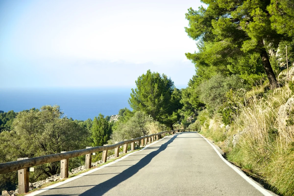
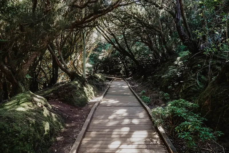
The walk is renowned for its challenging ascents and descents, which can be steep and demanding, contributing to its moderate-to-difficult rating. Hikers will traverse narrow, winding paths that cling to the sides of dramatic cliffs, offering panoramic views of the Atlantic Ocean and the rugged coastline. The air is often thick with moisture, creating a mystical atmosphere within the ancient forests, where moss-covered trees and ferns create a primeval environment. The route can be adapted to form a loop or a linear walk, depending on the specific starting point and desired endpoints, but the core experience involves navigating the wild, untamed landscapes of the Anaga Peninsula.
The biodiversity of the Anaga Rural Park is exceptional. The constant humidity from the trade winds, trapped by the mountains, supports a unique ecosystem that has survived since the Tertiary period. This includes numerous endemic plant species, such as the Canary Island laurel, wax myrtle, and various species of ferns. Birdlife is also abundant, with opportunities to spot species like the laurel pigeon and the Bolle's pigeon. The coastal sections offer views of the vast Atlantic, with waves crashing against the dramatic cliffs, a powerful reminder of the raw forces that shaped this landscape.
This route is not for the faint-hearted; it requires a good level of fitness and a head for heights. However, for those willing to undertake the challenge, the Anaga Coastal Route offers an unforgettable journey through a landscape of extraordinary natural beauty and ecological significance, a true hidden gem of the Canary Islands.
History and Cultural Context
The Anaga region of Tenerife holds a deep and ancient history, predating human settlement. The Anaga Massif itself is one of the oldest geological formations on the Canary Islands, with its volcanic origins dating back millions of years. This ancient landscape has been shaped by erosion, creating the dramatic ravines and rugged peaks that define the area today.
Human habitation in Anaga dates back to the indigenous Guanche people, who were the original inhabitants of the Canary Islands before the Castilian conquest in the 15th century. The Guanches were a Berber people who established a complex society, and evidence of their presence can still be found in the form of archaeological sites, including caves and ancient pathways. The remote and rugged terrain of Anaga provided a natural refuge for the Guanches, and their connection to this land is deeply ingrained in its cultural heritage.
Following the conquest, the area remained relatively isolated. The small villages, such as Chamorga, developed as agricultural communities, relying on the fertile volcanic soil and the unique microclimate to sustain themselves. Traditional farming practices, including terracing the steep hillsides, have been employed for centuries, shaping the landscape and preserving a way of life that has changed little over generations. The isolation also helped to preserve the unique flora and fauna of the region, contributing to its designation as a Biosphere Reserve.
In more recent times, the Anaga Massif has gained recognition for its exceptional natural value. In 2015, the Anaga Rural Park was declared a Biosphere Reserve by UNESCO, acknowledging its outstanding biodiversity, unique ecosystems, and the importance of sustainable land management practices. This designation aims to balance conservation with sustainable development, ensuring that the natural and cultural heritage of Anaga is protected for future generations. The Anaga Coastal Route, therefore, is not just a walk through a beautiful landscape, but a journey through a place rich in history, culture, and ecological significance.
Seasonal Highlights and Weather Reality
The Anaga Coastal Route is a year-round destination, but certain seasons offer distinct advantages and challenges.
Spring (March-May): This is arguably the best time to visit. The weather is typically mild and pleasant, with temperatures ranging from 15-22°C. The landscape is at its most vibrant, with wildflowers in bloom, particularly in the lower-lying areas and along the coast. The laurel forests are lush and green, and the persistent mist that often cloaks the higher elevations can create a magical, ethereal atmosphere. Rainfall is moderate, and the risk of extreme heat is low.
Summer (June-August): Summers in Anaga can be warm, with temperatures often reaching 25-30°C, especially at lower altitudes and on the coast. While the higher elevations may still experience cloud cover and cooler temperatures, the sun can be intense. The trade winds can provide some relief, but it's essential to carry plenty of water and sun protection. The forests remain green, but the undergrowth may be drier. This season is popular with tourists, so expect more people on the trails.
Autumn (September-November): Similar to spring, autumn offers excellent hiking conditions. The temperatures are mild, and the humidity levels are often high, which is ideal for the laurel forest ecosystem. The colours of the vegetation can be rich, and the light can be particularly beautiful for photography. Rainfall begins to increase towards the end of autumn, but it is usually not disruptive to hiking plans.
Winter (December-February): Winter in Anaga is generally mild, with average temperatures between 12-18°C. However, this is also the wettest period, with frequent rainfall and persistent cloud cover. The higher elevations can experience cooler temperatures, and fog can significantly reduce visibility, making navigation more challenging. Despite the rain, the forests are incredibly lush and green, and the dramatic coastal scenery is often enhanced by stormy seas. This season is best suited for experienced hikers who are prepared for wet conditions and reduced visibility.
Weather Reality: It is crucial to understand that the weather in Anaga can change rapidly and unpredictably. The mountains create their own microclimate, and it is common to experience sunshine, mist, rain, and wind all within a single hike. The trade winds are a constant factor, bringing moisture from the Atlantic, which is essential for the laurel forest but can also lead to damp and cool conditions, even in summer. Always check the local weather forecast before setting out and be prepared for all conditions.
Recommended Itinerary
Anaga Coastal Route - Chamorga Loop (Approx. 13 km)
This itinerary describes a popular loop starting and ending in Chamorga, offering a comprehensive experience of the Anaga Coastal Route.
Early Morning (Approx. 9:00 AM): Arrival in Chamorga
- Arrive in the small village of Chamorga.
- Park your vehicle (parking is limited and can fill up quickly, especially on weekends).
- Take a moment to appreciate the traditional architecture and the remote atmosphere of the village.
- Final check of gear, water, and snacks.
Morning (Approx. 9:30 AM): Descent towards the Coast
- Begin the hike by following the well-marked trail descending from Chamorga towards the coast.
- The initial section involves a steep descent through agricultural terraces and scrubland.
- Enjoy the first glimpses of the dramatic coastline and the vast Atlantic Ocean.
- Pass through areas with unique Canarian flora.
Midday (Approx. 12:00 PM): Coastal Path and Roque Bermejo
- The trail merges with the coastal path, offering spectacular views.
- Walk towards the iconic Roque Bermejo lighthouse.
- This section can be exposed to the elements, with strong winds and sun.
- Take a break near the lighthouse, perhaps at the small beach or viewpoint.
- This is a good spot for a packed lunch, but be mindful of the wind.
Afternoon (Approx. 1:30 PM): Ascent into the Laurel Forest
- Begin the challenging ascent back towards Chamorga, entering the dense laurel forest.
- The path becomes steeper and more rugged as you climb.
- Experience the unique microclimate of the laurisilva forest, often shrouded in mist.
- The air is cool and damp, and the vegetation is lush with mosses and ferns.
- Listen to the sounds of the forest and the occasional calls of endemic birds.
Late Afternoon (Approx. 4:00 PM): Return to Chamorga
- Continue the climb, navigating the winding forest trails.
- The path may become less distinct in places, so follow trail markers carefully.
- Emerging from the forest, you'll see the familiar landscape around Chamorga.
- Arrive back in Chamorga, completing the loop.
- Allow time for rest and reflection on the day's adventure.
Important Notes:
- This is a demanding hike with significant elevation changes.
- Wear sturdy hiking boots with good ankle support.
- Carry ample water (at least 2-3 litres per person) as there are no water sources on the trail.
- Sun protection (hat, sunscreen, sunglasses) is essential, especially on the coastal sections.
- Be prepared for rapidly changing weather conditions, including mist, rain, and wind.
- Carry a map or use a reliable GPS device, as trails can sometimes be unclear.
- The road to Chamorga is narrow and winding; drive with caution.
Planning and Bookings
Book Your Trip
Everything you need to plan your journey
Accommodation
Find places to stay near Santa Cruz de Tenerife
Flights
Search flights to Santa Cruz de Tenerife
Essential Preparation
The Anaga Coastal Route is a day hike, meaning no overnight accommodation is required. However, thorough preparation is crucial due to the remote location and challenging terrain. The nearest major town with comprehensive services is Santa Cruz de Tenerife. Access to the trailhead in Chamorga is primarily by car or public bus. Driving is the most flexible option, but be aware that the roads leading to Chamorga are narrow, winding, and can be steep. Parking in Chamorga is extremely limited, especially during peak times (weekends and holidays), so arriving early is highly recommended. Public transport is available via bus line 947 from Santa Cruz, but schedules can be infrequent, requiring careful planning to align with your hiking duration. Ensure you have a reliable offline map of the area, as mobile signal can be intermittent. It's advisable to have a basic understanding of the route and potential alternative paths in case of unexpected conditions.
Trail Accommodation
This is a day hike requiring no overnight accommodation.
Required Gear
- Sturdy Hiking Boots: Essential for navigating steep, uneven, and potentially slippery terrain. Good ankle support is highly recommended.
- Waterproof and Windproof Jacket: The weather in Anaga can change rapidly. A jacket that protects against rain and wind is crucial, even on seemingly clear days.
- Layered Clothing: Advise wearing moisture-wicking base layers, an insulating mid-layer (fleece or lightweight down jacket), and an outer shell. This allows for easy adjustment to changing temperatures and exertion levels.
- Sun Protection: A wide-brimmed hat, high SPF sunscreen, and sunglasses are vital, particularly for the exposed coastal sections.
- Navigation Tools: A detailed map of the Anaga Rural Park, a compass, and a GPS device or smartphone with offline maps are essential. Trail markers can sometimes be sparse or unclear.
- First-Aid Kit: A comprehensive kit including blister treatment, bandages, antiseptic wipes, pain relievers, and any personal medications.
- Head Torch: Even for a day hike, a head torch with spare batteries is advisable in case of unexpected delays or if starting very early/finishing late, especially in the dense forest where light can be limited.
What to Bring
- Water: Carry at least 2-3 litres of water per person. There are no reliable water sources along the trail.
- Food: High-energy snacks and a packed lunch are essential. Options include energy bars, nuts, dried fruit, sandwiches, and fruit.
- Toiletries: Biodegradable soap, hand sanitiser, and toilet paper (pack out all used paper).
- Backpack: A comfortable daypack (20-30 litres) to carry all your essentials.
- Trekking Poles: Highly recommended for the steep ascents and descents, as they help reduce strain on knees and improve stability.
- Camera: To capture the stunning scenery.
- Mobile Phone: Fully charged, with a power bank if possible, for emergencies.
Permits
No specific permits are required to hike the Anaga Coastal Route or to enter the Anaga Rural Park. The park is a protected area, and while there are regulations in place to preserve its natural and cultural heritage, general access for hiking is permitted without the need for advance booking or special permits. However, it is important to be aware of the park's rules and guidelines, which are designed to minimise human impact on the fragile ecosystem. These typically include staying on marked trails, not disturbing wildlife, not removing any plants or geological samples, and packing out all litter. For specific events or organised group activities, there might be different requirements, but for individual or small group day hiking, no permits are necessary.
Other Activities in the Area
Beyond the Anaga Coastal Route, the Anaga Rural Park and its surroundings offer a wealth of activities for nature enthusiasts and cultural explorers:
- Exploring Chamorga Village: Spend time wandering through the charming, traditional village of Chamorga. Admire the unique architecture, visit the small church, and soak in the peaceful, remote atmosphere.
- Other Hiking Trails: The Anaga Rural Park is crisscrossed with numerous well-marked hiking trails, catering to various fitness levels and interests. Popular options include the Sendero de los Sentidos (Path of the Senses), which offers an accessible introduction to the laurel forest, and trails leading to other remote hamlets and viewpoints.
- Visiting Taganana: A picturesque village nestled in the mountains, Taganana is known for its traditional houses, historic church, and proximity to stunning black sand beaches like Playa de Benijo and Playa de Almáciga.
- Beach Exploration: The rugged coastline of Anaga features several dramatic black sand beaches, such as Playa de Benijo, Playa de Almáciga, and Playa de las Teresitas (further afield but accessible). These beaches offer a wild and beautiful contrast to the mountain scenery.
- Birdwatching: The Anaga Massif is a haven for endemic bird species, including the laurel pigeon (Columba junoniae) and Bolle's pigeon (Columba bollii). The dense laurel forests provide excellent habitat for these rare birds.
- Driving the Scenic Roads: The winding roads through the Anaga mountains offer spectacular viewpoints and a chance to appreciate the scale and beauty of the landscape from different perspectives.
- Visiting Santa Cruz de Tenerife: The capital city offers a range of cultural attractions, including the Auditorio de Tenerife, the Palmetum botanical gardens, and the historic city centre.
Safety and Conditions
Weather Preparedness: The most significant safety consideration in Anaga is the unpredictable weather. Mist can descend rapidly, reducing visibility to mere metres, and rain can make trails slippery and challenging. Always check the weather forecast for the Anaga region specifically before you depart and be prepared for cooler temperatures and damp conditions, even in summer. Carry waterproofs and warm layers.
Trail Conditions: Trails can be steep, narrow, and uneven, with loose scree and rocky sections. Good quality hiking boots with ankle support are essential. Trekking poles can significantly aid stability and reduce strain on joints, especially during descents. Be mindful of potential erosion and unstable ground, particularly after heavy rain.
Navigation: While trails are generally marked, signage can sometimes be sparse or confusing, especially in the dense laurel forest where visibility can be poor. It is highly recommended to carry a detailed map of the Anaga Rural Park and a compass, or use a reliable GPS device with offline maps downloaded. Inform someone of your hiking plans, including your intended route and expected return time.
Water and Food: There are no facilities for purchasing water or food along the Anaga Coastal Route. You must carry all your requirements for the entire duration of the hike. Dehydration is a risk, especially on warmer days or during strenuous ascents.
Remote Location: Chamorga is a remote village, and mobile phone reception can be intermittent. In case of an emergency, it may be difficult to contact help. Consider carrying a personal locator beacon (PLB) if hiking alone or in very remote areas. The nearest medical facilities are in Santa Cruz de Tenerife.
Sun Exposure: While the forest sections offer shade, the coastal parts of the route are often exposed to direct sunlight. Protect yourself from sunburn with high SPF sunscreen, a hat, and sunglasses.
Respect the Environment: Stay on marked trails to avoid damaging fragile vegetation and to prevent erosion. Do not disturb wildlife or remove any natural elements from the park.
Side Trips and Points of Interest
Roque Bermejo Lighthouse: A prominent landmark on the coastal section of the route. The lighthouse stands on a dramatic rocky outcrop overlooking the Atlantic Ocean. The surrounding area offers stunning panoramic views and is a popular spot for photography. There is a small, often deserted, beach nearby, providing a picturesque place to rest and enjoy the sea air.
Chamorga Village: The starting and ending point of the loop, Chamorga is a traditional Canarian village that feels like a step back in time. Its stone houses, agricultural terraces, and quiet atmosphere offer a glimpse into rural life in the Anaga region. The village church is a focal point and adds to the charm.
Laurisilva Forest: The dense, ancient laurel forest that covers much of the Anaga Massif is a unique ecosystem. The trail passes through this magical environment, characterised by its high humidity, moss-covered trees, ferns, and a rich undergrowth. The mist often present in these forests creates an ethereal, almost prehistoric atmosphere.
Agricultural Terraces: As you descend from Chamorga, you will pass through areas with traditional agricultural terraces. These are a testament to centuries of human effort in cultivating the steep slopes of Anaga, showcasing the ingenuity of past generations in adapting to the challenging terrain.
Dramatic Coastal Cliffs: The route offers breathtaking views of the rugged Anaga coastline, with sheer cliffs plunging into the Atlantic. The power of the ocean is evident as waves crash against the volcanic rock, creating a dramatic and awe-inspiring spectacle.
Leave No Trace
The Anaga Rural Park is a precious natural and cultural heritage site, designated as a UNESCO Biosphere Reserve. To preserve its unique ecosystems and pristine beauty for future generations, it is imperative that all visitors adhere to Leave No Trace principles. Your actions have a direct impact on this fragile environment.
Plan Ahead and Prepare: Research the trail, understand its challenges, and be prepared for all weather conditions. Pack appropriate gear and sufficient supplies, including water and food, as facilities are scarce.
Travel and Camp on Durable Surfaces: Stick to marked trails at all times. The vegetation in Anaga, especially the delicate mosses and ferns in the laurel forest, can take years to recover from damage. Avoid shortcuts, which can lead to erosion and habitat destruction.
Dispose of Waste Properly: Pack out everything you pack in. This includes all food scraps, wrappers, and any other litter. Use designated bins where available, but be prepared to carry all waste back with you. If you need to use the toilet, do so away from water sources and bury human waste at least 15 cm deep, packing out all toilet paper.
Leave What You Find: Do not take any natural souvenirs, such as rocks, plants, or flowers. These are part of the ecosystem and should be left for others to enjoy and for the environment to sustain.
Minimise Campfire Impacts: Campfires are generally not permitted in the Anaga Rural Park. If they were allowed in designated areas, use existing fire rings and ensure fires are completely extinguished before leaving.
Respect Wildlife: Observe wildlife from a distance and never feed them. Feeding wild animals can disrupt their natural behaviours, diets, and health. The Anaga Massif is home to endemic species that are particularly vulnerable.
Be Considerate of Other Visitors: Keep noise levels down, especially in natural settings. Yield to other hikers on narrow trails. Respect the local culture and traditions of the villages you pass through.