Altyn Arashan to Ala-Kul Pass - The Jewel of the Tian Shan
The trek from the Karakol Valley over the Ala-Kul Pass to Altyn Arashan is widely considered the most spectacular multi-day hike in Kyrgyzstan. Spanning approximately 37 kilometres through the heart of the Terskey Alatau range, part of the legendary "Celestial Mountains" of the Tian Shan, this route offers a concentrated dose of Central Asian wilderness. The journey is defined by its dramatic transitions: from the lush, pine-scented forests of the Karakol Valley to the stark, high-altitude moonscapes of the Ala-Kul Pass (3,915 metres), and finally descending into the geothermal paradise of Altyn Arashan. The centrepiece of the trek is Ala-Kul itself, a high-alpine lake of impossible turquoise that changes hue depending on the angle of the sun and the movement of the clouds. This is a challenging mountain track that demands physical resilience, respect for high-altitude weather, and a spirit of adventure, rewarded by some of the most breathtaking vistas in the former Soviet Union.
- Distance: 37.0 km (point-to-point traverse)
- Duration: 3 days / 2 nights (can be extended to 4 days for a more relaxed pace)
- Season: July to September (snow can block the pass outside this window)
- Accommodation: Wild camping, basic mountain huts, and traditional Kyrgyz yurts
- Highest point: Ala-Kul Pass (3,915 m)
- Total Elevation Gain: Approximately 1,800 m
- Difficulty: Challenging (requires steep ascents, scree navigation, and altitude acclimatisation)
- Closest City: Karakol, Issyk-Kul Region
Overview
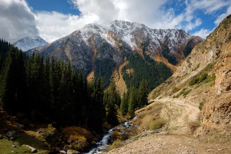
Kyrgyzstan is a land of verticality, and the Altyn Arashan to Ala-Kul Pass circuit is its premier showcase. The trek is typically completed as a traverse, starting in the Karakol Valley and ending in the Ak-Suu village via the Altyn Arashan valley. This direction is generally preferred as it allows for a more gradual acclimatisation before tackling the formidable 3,915-metre pass. The landscape is a masterclass in alpine diversity. You begin in the lower valleys where the Karakol River thunders alongside trails lined with ancient Schrenk's spruce—a species endemic to the Tian Shan that grows tall and narrow, resembling dark green needles against the sky. As you ascend, the forest thins, giving way to alpine meadows (jailoos) where semi-nomadic Kyrgyz shepherds graze their horses and fat-tailed sheep during the summer months.
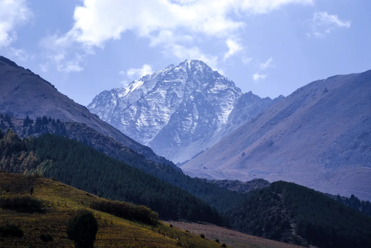
The ascent to Ala-Kul Lake is a gruelling test of stamina, involving a steep climb through the "Sirota" forest and up onto the rocky moraine. The lake itself, sitting at 3,560 metres, is a geological marvel. Fed by the surrounding glaciers, its waters are rich in glacial flour, creating a vibrant, milky turquoise colour that contrasts sharply with the surrounding grey granite peaks and white snowfields. The lake is roughly 2.8 kilometres long and 500 metres wide, but its scale feels much larger when viewed from the surrounding ridges. The climb from the lake to the Ala-Kul Pass is the technical crux of the journey. The trail turns into a steep, shifting scree slope where for every two steps forward, you often slide one back. Reaching the summit of the pass provides a 360-degree panorama that includes the 5,000-metre peaks of Karakol Peak and Djigit Peak, their glaciers spilling down like frozen rivers.
The final leg of the journey descends into the Altyn Arashan valley, which translates to "Golden Spa." This valley is famous for its natural hot springs, which have been used for centuries for their purported healing properties. After days of strenuous hiking in thin air and cold temperatures, soaking in a 40-degree Celsius sulfur bath while looking out at the snow-capped "Palatka" (Tent) Peak is an experience of pure mountain luxury. The trek concludes with a long, scenic walk down the Arashan River to the village of Ak-Suu, where the rugged wilderness finally gives way to the rural charm of Kyrgyz village life.
History and Cultural Context
The mountains of the Terskey Alatau have served as a backdrop to the shifting tides of Central Asian history for millennia. While the high passes were never the primary routes for the Great Silk Road—which generally favoured the lower, more accessible valleys to the south and north—they were vital for local nomadic tribes moving livestock between seasonal pastures. The Kyrgyz people are traditionally semi-nomadic, and their culture is inextricably linked to the mountains. The "jailoo" (summer pasture) system remains active today; during your trek, you will likely encounter yurt camps where families live from June to September, producing "kymyz" (fermented mare's milk) and "kurut" (dried yogurt balls).
During the Soviet era, the region around Karakol became a major hub for mountaineering and alpine research. The Soviet Union placed a high value on physical culture and exploration, and the Tian Shan mountains were used as a training ground for elite climbers preparing for expeditions to the Pamirs or the Himalayas. Many of the trails used today were originally mapped or improved by Soviet mountaineering clubs. Altyn Arashan itself was developed as a small resort area during this period, with basic wooden lodges built to house scientists and high-ranking officials seeking the therapeutic benefits of the mineral springs. The name "Altyn Arashan" reflects the local reverence for the land; "Altyn" means golden, and "Arashan" refers to a sacred or healing spring.
Karakol, the base town for the trek, has its own unique history. Founded as a Russian military outpost in 1869, it grew into a cosmopolitan melting pot. This is reflected in the town's architecture, such as the Holy Trinity Orthodox Cathedral, built entirely of wood without nails, and the Dungan Mosque, constructed by Chinese Muslims who fled persecution in the 19th century. The mosque resembles a Buddhist temple and was also built without metal nails. Understanding this blend of nomadic Kyrgyz traditions, Russian colonial influence, and Dungan culture adds a rich layer of depth to the trekking experience, as you realise you are walking through a landscape that has been a crossroads of civilisations for centuries.
Want more background? Read extended notes on history and cultural context → Learn more
Seasonal Highlights and Weather Reality
The window for trekking to Ala-Kul is relatively narrow due to the high altitude of the pass. Outside of the peak summer months, the route can be dangerous or impassable for those without specialised winter mountaineering equipment and experience.
July and August (Peak Season): This is the most reliable time to attempt the trek. The snow on the Ala-Kul Pass has usually melted enough to reveal the trail, and the daytime temperatures in the valleys are pleasantly warm (20-25°C). However, even in mid-summer, the weather at 3,900 metres is unpredictable. Afternoon thunderstorms are common, and it is not unusual to experience sleet or light snow at the pass even in August. The alpine flowers are in full bloom during this period, carpeting the meadows in shades of purple, yellow, and blue.
September (Shoulder Season): Early to mid-September can be a magical time to hike. The crowds of the high summer have thinned, and the air is often crisper and clearer, providing exceptional visibility for photography. The larch trees begin to turn gold, and the first dustings of autumn snow appear on the high peaks. However, the nights become significantly colder, often dropping well below freezing at the higher campsites. By late September, the risk of a major snowstorm closing the pass increases significantly.
June (Early Season): While the lower valleys are beautiful in June, the Ala-Kul Pass is often still covered in deep, unstable snow. Attempting the pass in June usually requires crampons and an ice axe, and the risk of avalanches on the steep slopes above the lake is a serious consideration. Many of the yurt camps in Altyn Arashan may not be fully operational until late June.
October to May (Winter): During the winter months, the trek becomes a serious alpine undertaking. The Karakol Valley and Altyn Arashan are accessible for snowshoeing or ski touring, but the Ala-Kul Pass is strictly for experienced mountaineers. Temperatures can drop to -30°C, and the region is prone to heavy snowfall and high avalanche danger.
Recommended Itinerary
3-Day Ala-Kul Traverse Itinerary
Day 1: Karakol Valley to Sirota Camp
- Distance: 14 km
- Elevation gain: 800 m
- Time: 5–6 hours
- Take a marshrutka or taxi from Karakol to the entrance of the Karakol National Park
- Follow the 4x4 track along the Karakol River through dense spruce forests
- Cross the river via a wooden bridge and begin the steep ascent toward the Ala-Kul valley
- The trail climbs through a narrow gorge, following a cascading stream
- Arrive at "Sirota" camp, a popular wooded campsite featuring a small log cabin (often used as a shelter) and carved wooden totems
- Set up camp under the trees; this is the last sheltered spot before the exposed alpine zone
- The evening air here is cool and fresh, with the sound of the river providing a constant backdrop
Day 2: Sirota Camp to Altyn Arashan via Ala-Kul Pass
- Distance: 12 km
- Elevation: 1,100 m gain, 1,300 m descent
- Time: 8–10 hours
- An early start (6:00 AM) is essential to ensure you cross the pass before any afternoon weather changes
- The trail climbs steeply from Sirota over rocky moraine to reach the shores of Ala-Kul Lake (3,560 m)
- Follow the trail along the left (north) side of the lake, offering spectacular views of the turquoise water against the glaciers
- The final ascent to the Ala-Kul Pass (3,915 m) is a steep, 300-metre climb on loose scree
- From the summit, enjoy views of the 5,000m peaks of the Terskey Alatau
- The descent into the Keldyke Valley is very steep and requires careful footwork on loose rock
- Follow the Keldyke River down through alpine meadows where horses often graze
- Arrive at the Altyn Arashan valley (2,500 m) in the late afternoon
- Check into a yurt or guesthouse and immediately head for the hot springs to soak tired muscles
Day 3: Altyn Arashan to Ak-Suu Village
- Distance: 11 km
- Elevation: 600 m descent
- Time: 3–4 hours
- Enjoy a final soak in the hot springs and a hearty Kyrgyz breakfast
- The walk out follows the Arashan River down a wide, scenic gorge
- The trail is a rough 4x4 road, but the scenery remains impressive with high cliffs and rushing water
- Pass through several gates used by local shepherds to manage livestock
- The trek ends at the village of Ak-Suu (Teploklyuchenka)
- From Ak-Suu, catch a local marshrutka (No. 350) for the 30-minute ride back to Karakol
- Celebrate the completion of the trek with a "Dungan Ashlan-Fu" (cold spicy noodle soup), a local Karakol specialty
Important Notes:
- This itinerary assumes a high level of fitness; if you prefer a slower pace, add a night at Ala-Kul Lake
- Water is plentiful along the route, but must be treated due to livestock
- The descent from the pass is notoriously hard on the knees; trekking poles are highly recommended
- Weather can change in minutes; always have your waterproof layers easily accessible
- If the pass is covered in fresh snow, reconsider the crossing as the scree becomes dangerously slippery
Planning and Bookings
Book Your Trip
Everything you need to plan your journey
Accommodation
Find places to stay near Karakol
Flights
Search flights to Karakol
Essential Preparation
The Altyn Arashan to Ala-Kul trek requires careful logistical planning, primarily centred around the town of Karakol. Karakol is the administrative and tourism hub of eastern Kyrgyzstan and serves as the perfect base for gear rental, food shopping, and arranging transport. Most trekkers arrive in Karakol from Bishkek via a 6-hour marshrutka (minibus) ride or a private taxi. It is highly recommended to spend at least one full day in Karakol (which sits at 1,700 metres) to begin the acclimatisation process and organise your supplies.
Physical fitness is a significant factor. You will be carrying a full pack (unless you hire a porter) over a 3,900-metre pass. The air is noticeably thinner above 3,000 metres, and altitude sickness is a real possibility. Ensure you are comfortable with steep ascents and descents on loose terrain. There is no formal booking system for the trail itself, but if you plan to stay in specific guesthouses in Altyn Arashan during the peak of August, a quick phone call or message via WhatsApp (the primary communication tool in Kyrgyzstan) a few days in advance is wise.
Trail Accommodation
Accommodation on this trek is a mix of wild camping and rustic mountain hospitality. There are no "Great Walk" style huts with wardens and gas stoves; you must be self-sufficient or rely on local yurt camps.
Accommodation Options:
- Wild Camping: Allowed anywhere along the route. Popular spots include the Karakol River banks, Sirota Camp, and the shores of Ala-Kul Lake. You must bring your own tent, sleeping bag, and mat.
- Sirota Hut: A very basic, unmanaged log cabin. It is often dirty and should only be used as an emergency shelter. Camping in the surrounding woods is much more pleasant.
- Ala-Kul Lake Tents: During July and August, some local operators set up "tent camps" near the lake where you can rent a spot in a pre-erected tent and buy basic meals. These are not guaranteed and should not be relied upon as your primary plan.
- Altyn Arashan Guesthouses/Yurts: Several small, family-run lodges (like Elza's or Ala-Kul Guesthouse) offer basic rooms or beds in a shared yurt. Facilities include pit toilets, communal dining areas, and, most importantly, access to private or public hot spring cabins.
Facilities and Costs:
- Guesthouse/Yurt stay: Approximately 1,500–2,500 KGS (Kyrgyz Som) per night, including dinner and breakfast.
- Hot spring access: Usually 200–400 KGS for a 30-minute soak.
- No electricity is available between the trailhead and Altyn Arashan; bring a power bank.
- In Altyn Arashan, some guesthouses have limited solar power or generators for evening lighting.
Required Gear
- Trekking Boots: Sturdy, waterproof boots with deep tread are essential. The scree on the pass and the muddy sections in the forest will punish flimsy footwear.
- Trekking Poles: Not optional for most people. They are vital for stability on the steep scree descent from the pass and for saving your knees.
- High-Quality Tent: Must be able to withstand high winds and potential snow. A 3-season tent is the minimum requirement.
- Sleeping Bag: Rated to at least -5°C comfort. Even in summer, temperatures at Ala-Kul Lake (3,560 m) frequently drop below freezing at night.
- Layered Clothing: Merino wool base layers, a warm fleece or down jacket, and a high-quality waterproof shell. The "onion" method of layering is the only way to manage the extreme temperature swings.
- Navigation: A GPS-enabled smartphone with offline maps (like Maps.me or Gaia GPS) is excellent, but carry a paper map and compass as a backup. The trail is generally clear but can be lost in fog or snow.
- Sun Protection: High-altitude sun is incredibly intense. Bring SPF 50+ sunscreen, a wide-brimmed hat, and Category 3 or 4 sunglasses to prevent snow blindness.
What to Bring
- Food: You must carry all food for the first two days. Lightweight, high-calorie options like dried fruits, nuts, instant noodles, and dehydrated meals are best. You can buy hot meals in Altyn Arashan on the final night.
- Cooking System: A lightweight camping stove (gas canisters are easily purchased in Karakol at trekking shops like Destination Karakol). Note that liquid fuel is harder to find than screw-top gas canisters.
- Water Treatment: A filter (like a Sawyer Squeeze) or purification tablets. While the water looks pristine, the presence of thousands of grazing animals means the risk of Giardia or E. coli is high.
- First Aid Kit: Include blister pads (moleskin), antiseptic wipes, and medications for altitude sickness (Diamox - consult a doctor first), ibuprofen, and anti-diarrhoeals.
- Personal Items: Biodegradable toilet paper, hand sanitiser, and a small towel for the hot springs.
- Cash: Bring enough Kyrgyz Som for your transport, guesthouse stays, and hot springs. There are no ATMs in the mountains, and card payments are not accepted.
Permits
One of the great appeals of trekking in the Karakol region is the lack of complex bureaucracy. For most nationalities, Kyrgyzstan is visa-free for up to 60 days, making it the most accessible country in Central Asia for independent travellers.
National Park Fees:
- The trek passes through the Karakol National Park. You will encounter a small gate/kiosk at the entrance of the Karakol Valley.
- The entry fee is approximately 250 KGS per person, plus a small fee for a vehicle if you are taking a taxi to the trailhead.
- Keep your receipt, as rangers occasionally check them further up the valley.
- There is currently no fee for entering the Altyn Arashan valley from the Ak-Suu side.
Border Zone Permits:
- A common point of confusion for trekkers in Kyrgyzstan is the "Border Zone Permit" (Propusk). This is required for areas very close to the Chinese border (like Inylchek Glacier or parts of the Ak-Suu Traverse).
- The Altyn Arashan to Ala-Kul Pass trek does NOT require a border permit. You are free to hike this route with just your passport and the national park entry receipt.
- However, if you plan to extend your hike significantly further south or east toward the high peaks of the central Tian Shan, you should check current regulations at the Destination Karakol office.
Registration:
- While not a "permit," some nationalities are required to register with the local police (OVIR) if staying in Kyrgyzstan for more than a certain number of days (usually 30 or 60 depending on the country). Check your specific visa requirements before heading into the mountains for multiple days.
Other Activities in the Area
Karakol and the surrounding Issyk-Kul region offer a wealth of experiences that complement a high-altitude trek:
- Karakol Animal Market: Held every Sunday morning on the outskirts of town. It is one of the largest and most authentic livestock markets in Central Asia. Watching farmers haggle over horses, sheep, and cows is a fascinating cultural spectacle. Arrive by 6:00 AM for the best action.
- Jeti-Oguz (Seven Bulls): A famous rock formation of red sandstone located about 25 km from Karakol. It is a beautiful spot for a day trip or a shorter, easier hike through the "Valley of Flowers."
- Issyk-Kul Lake: The second-largest alpine lake in the world. After your trek, head to the south shore (near Tamga or Tosor) for some relaxation on the "beaches" and a swim in the slightly salty, crystal-clear water.
- Dungan Village Visit: Take a food tour in the nearby village of Yrdyk to learn about Dungan culture and enjoy a traditional multi-course home-cooked meal.
- Skazka (Fairytale) Canyon: Located on the south shore of Issyk-Kul, this canyon features bizarre red rock formations that resemble dragons, castles, and giants. It is a photographer's dream, especially at sunset.
- Eagle Hunting Demonstrations: In the villages along the south shore, you can meet traditional "berkutchi" (eagle hunters) who still practice the ancient art of hunting with golden eagles.
Safety and Conditions
Altitude Sickness (AMS): This is the primary safety concern on the Ala-Kul trek. You will be ascending from 1,700 m to nearly 4,000 m in two days. Symptoms of Acute Mountain Sickness include headache, nausea, dizziness, and fatigue. The best prevention is a gradual ascent and staying hydrated. If symptoms persist or worsen, the only cure is to descend immediately. Do not attempt to cross the pass if you are feeling unwell.
Weather Volatility: The Tian Shan mountains create their own weather systems. A clear morning can turn into a blizzard or a violent thunderstorm by mid-afternoon. Always check the forecast at the Destination Karakol office before leaving, but be prepared for the worst. Lightning is a genuine danger on the exposed Ala-Kul Pass; if you hear thunder or see dark clouds building, do not summit the pass.
River Crossings: Early in the season (June/July), snowmelt can make river crossings in the Karakol and Keldyke valleys challenging. Always unclip your backpack's waist belt when crossing deep water so you can jettison the pack if you fall. Look for the widest, shallowest point of the river, usually where it breaks into several smaller channels.
Wildlife and Livestock: You may encounter shepherd dogs guarding flocks. These dogs are bred to be aggressive toward predators. If approached, do not run. Stand your ground, speak calmly, and wait for the shepherd, or slowly back away. Bears and wolves exist in the Tian Shan but are extremely elusive and rarely encountered by trekkers. The most common "wildlife" issue is marmots chewing on salty gear left outside your tent.
Emergency Communication: There is no mobile signal for most of the trek. Signal is only available near the trailhead and occasionally in Altyn Arashan. Carrying a satellite communication device (like a Garmin inReach) is highly recommended for solo hikers or those attempting the route in the shoulder season. Ensure someone in Karakol knows your intended route and expected return date.
Side Trips and Points of Interest
The "Sirota" Totems: At the Sirota campsite, look for the whimsical wooden carvings left by hikers and locals over the years. There is a small "table" and benches made of logs, making it a great spot for a mid-trek lunch even if you aren't camping there. The name "Sirota" means "orphan" in Russian, referring to the isolated nature of the cabin.
Ala-Kul Glacier: For those with an extra day and mountaineering experience, a side trip from the lake toward the glaciers at the head of the valley offers a close-up look at the raw power of the Tian Shan's ice fields. This requires navigating unstable moraine and should not be attempted alone.
The Radon Baths of Altyn Arashan: While most visitors use the sulfur springs, there are also radon springs in the valley. These are believed to be particularly effective for treating joint pain and skin conditions. The "baths" are usually small, private wooden huts built over the spring source. The water is naturally hot (around 38-41°C) and incredibly relaxing.
Palatka Peak Viewpoint: From the Altyn Arashan guesthouses, a short but steep 1-hour hike up the eastern ridge of the valley provides a stunning view of Palatka Peak (4,733 m). The mountain is named "The Tent" because of its distinctive flat-topped, snow-covered summit that resembles a classic A-frame tent.
The Arashan Waterfall: About 2 kilometres south of the Altyn Arashan guesthouses, a powerful waterfall thunders down from a side valley. It is an easy walk and a great way to spend an afternoon if you decide to stay an extra night in the valley to recover.
Leave No Trace
Kyrgyzstan's wilderness is vast, but it is increasingly under pressure from tourism. The Ala-Kul route is the most popular in the country, and the impact of human waste and litter is becoming visible. As a visitor, you have a responsibility to maintain the purity of this landscape.
Specific LNT Guidelines for Kyrgyzstan:
- Waste Management: There is no trash collection in the mountains. Everything you carry in, you MUST carry out. This includes "micro-trash" like fruit stickers and cigarette butts. Do not leave trash at Sirota or in the yurt camps; they have no way to dispose of it other than burning or burying it.
- Human Waste: Use the pit toilets at Sirota and Altyn Arashan whenever possible. If you must go in the wild, dig a "cathole" at least 15-20 cm deep and at least 60 metres away from any water source. Pack out your used toilet paper in a sealed plastic bag.
- Water Purity: Do not use soap (even biodegradable soap) directly in the lakes or streams. Carry water 60 metres away from the source for washing yourself or your dishes.
- Respect the Jailoos: You are walking through someone's summer home and workplace. Always ask permission before filming or photographing people in yurt camps. If offered tea or bread, it is polite to accept, but consider offering a small gift or a few Som in return for their hospitality.
- Fire Safety: Avoid making campfires. Wood is scarce at high altitudes, and the Schrenk's spruce forest is highly flammable. Use a camping stove for all cooking.