Altos de Lircay Trek - Andean Wilderness
The Altos de Lircay Trek is a captivating multi-day journey through the heart of Chile's Andes, offering a profound immersion into high-altitude landscapes, pristine alpine lakes, and rugged mountain terrain. Located within the Parque Nacional Altos de Lircay, this trek is a testament to the raw beauty and ecological significance of the central Chilean Andes. Unlike more manicured trails, Altos de Lircay presents a wilder, more challenging experience, demanding self-sufficiency and a deep respect for the mountain environment. The trail winds through diverse ecosystems, from fragrant ñire forests to windswept páramo, culminating in breathtaking vistas of snow-capped peaks and glacial cirques. This is a trek for those seeking solitude, dramatic scenery, and a genuine connection with the Andean wilderness, far from the crowds.
- Distance: 35.0 km one-way
- Duration: 3-4 days
- Season: October to April (Spring to Autumn)
- Huts/Campsites: Basic campsites available; no formal huts
- Highest point: Approximately 2,800 m
- Daily walkers: Limited by park regulations and self-sufficiency
- Direction: Typically starts at Vilches Alto and ends at a different park exit, or can be done as a loop with variations
Overview
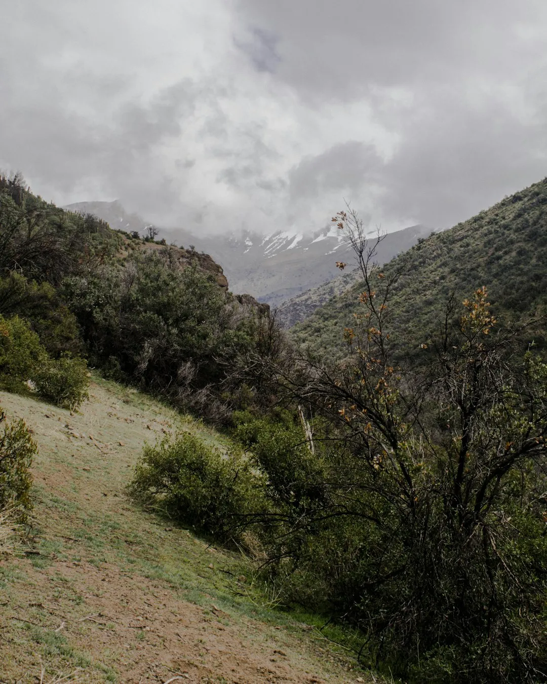
The Altos de Lircay Trek is a journey into the high Andes of central Chile, a region renowned for its dramatic geological formations, unique flora and fauna, and challenging alpine conditions. The trek typically begins near Vilches Alto, a gateway town that provides access to the Parque Nacional Altos de Lircay. From here, the trail ascends through fragrant ñire (Nothofagus antarctica) forests, their gnarled branches creating a sense of ancient woodland. As the elevation increases, the vegetation transitions to more open alpine meadows and eventually to the stark beauty of the páramo, a high-altitude grassland ecosystem adapted to harsh conditions.
A significant feature of the trek is the series of glacial lakes and lagoons scattered throughout the park. These pristine bodies of water, often reflecting the surrounding snow-capped peaks, offer moments of serene beauty amidst the rugged landscape. The highest points of the trek involve navigating passes and ridges that provide panoramic views of the vast Andean cordillera. The scale of the landscape is immense, with jagged peaks, deep valleys, and expansive skies creating a sense of awe and insignificance.
The trek is known for its challenging terrain, which can include steep ascents, rocky paths, and potentially snow-covered sections, especially in the shoulder seasons. Weather in the Andes is notoriously unpredictable, with rapid changes from sunshine to storms being common. This necessitates a high degree of preparedness and self-reliance. The Altos de Lircay Trek is not a walk in the park; it is an expedition into a wild and beautiful environment that rewards the prepared and adventurous hiker with unparalleled natural splendour and a profound sense of accomplishment.
History and Cultural Context
The region encompassing the Altos de Lircay National Reserve has a long history of human interaction, primarily shaped by indigenous Mapuche peoples and later by Chilean settlers and explorers. For centuries, the Andes served as a natural frontier and a source of resources for indigenous communities. The high mountain passes were used for seasonal migration and trade, connecting different valleys and communities.
During the colonial period and the early years of the Chilean Republic, the Andes remained a largely untamed frontier. Explorers and geologists began to chart the region in the 19th and early 20th centuries, documenting its mineral wealth and unique ecosystems. The establishment of national parks and reserves in the mid-20th century, including the creation of the Altos de Lircay National Reserve (later expanded and integrated into a larger protected area), marked a shift towards conservation and the recognition of the area's ecological and scenic importance.
The development of trekking routes within the park has been a gradual process, often driven by local guides and enthusiasts rather than formal government initiatives. The trails are generally less developed than those in more established international hiking destinations, reflecting a more rugged and natural approach to wilderness access. The park's relative remoteness and the challenging terrain have preserved its wild character, making it a destination for those seeking an authentic Andean trekking experience. The cultural context of the region is also tied to the agricultural communities in the foothills, whose livelihoods have historically been intertwined with the mountain environment.
Seasonal Highlights and Weather Reality
The best time to undertake the Altos de Lircay Trek is during the austral spring and summer, from October to April. This period offers the most favourable weather conditions for high-altitude trekking in the Andes.
Spring (October to November): This season sees the landscape awakening after winter. Snowmelt begins to feed the rivers and fill the alpine lakes, creating vibrant blue waters. Wildflowers start to bloom in the lower elevations, adding splashes of colour to the emerging green meadows. However, higher passes may still hold significant snow, and early spring can still experience cold temperatures and unpredictable weather, including late snowfalls. Days are lengthening, offering more daylight for hiking.
Summer (December to February): This is generally considered the prime trekking season. Temperatures are milder, though still cool at higher altitudes, and the days are long. The páramo is at its most vibrant, and the lakes are typically clear and inviting. This is also the period with the highest probability of clear skies and stable weather, offering the best chances for spectacular panoramic views. However, summer can also bring afternoon thunderstorms, which are common in mountainous regions. Sandflies can be present, though generally less of an issue than in some other parts of the world.
Autumn (March to April): The autumn months offer a different kind of beauty. The foliage of the ñire trees turns to stunning shades of red, orange, and yellow, creating a spectacular display of colour. The air is crisp and clear, and the crowds of summer have thinned. However, temperatures begin to drop significantly, and the first snowfalls of the season can occur, particularly at higher elevations. Days become shorter, and the risk of encountering icy conditions on the trails increases.
Winter (May to September): The Andes in this region experience harsh winter conditions. Heavy snowfall blankets the higher elevations, making the trails impassable for most trekkers. Temperatures plummet well below freezing, and strong winds are common. This season is only suitable for experienced mountaineers with specialised winter gear and knowledge of avalanche safety.
Weather Reality: Regardless of the season, weather in the Andes is highly variable. Trekkers must be prepared for rapid changes, including strong winds, rain, hail, and snow, even during the summer months. Hypothermia is a genuine risk, and layers of warm, waterproof, and windproof clothing are essential.
Recommended Itinerary
3-Day Altos de Lircay Trek Itinerary
Day 1: Vilches Alto to Campamento Los Peumos
- Distance: Approximately 10 km
- Elevation gain: Approximately 600 m
- Time: 4–5 hours
- Start at the park entrance near Vilches Alto
- Initial ascent through fragrant ñire forests
- Pass by smaller streams and emerging alpine meadows
- Reach Campamento Los Peumos, a designated camping area with basic facilities
- Set up camp and acclimatise to the altitude
- Enjoy the surrounding views as the sun begins to set over the foothills
Day 2: Campamento Los Peumos to Laguna del Alto
- Distance: Approximately 15 km
- Elevation gain: Approximately 900 m
- Time: 6–8 hours
- Continue ascent into higher alpine terrain
- Traverse open páramo landscapes with unique flora
- Pass several smaller glacial lakes and streams
- Reach Laguna del Alto, a stunning high-altitude lake nestled beneath dramatic peaks
- Set up camp near the lake, offering spectacular reflections and mountain vistas
- Explore the immediate surroundings of the lake
Day 3: Laguna del Alto to Vilches Alto (or alternative exit)
- Distance: Approximately 10 km
- Elevation loss: Approximately 1,500 m
- Time: 4–5 hours
- Enjoy a final sunrise over Laguna del Alto
- Begin the descent back towards Vilches Alto
- The descent offers different perspectives of the landscape
- Re-enter the ñire forests as you approach the park entrance
- Arrive back at Vilches Alto, concluding the trek
Important Notes:
- This itinerary is a suggestion and can be adapted based on fitness, weather, and personal preference.
- Camping is the primary accommodation; ensure you have appropriate gear.
- Water sources are generally available but should be treated.
- Park entry fees and registration are mandatory.
- Weather can change rapidly; always be prepared for alpine conditions.
- Navigation skills are essential as trails can be indistinct in places.
Planning and Bookings
Book Your Trip
Everything you need to plan your journey
Accommodation
Find places to stay near Talca
Flights
Search flights to Talca
Essential Preparation
The Altos de Lircay Trek requires careful planning due to its remote location and the need for self-sufficiency. The closest major city is Talca, which serves as the primary logistical hub. From Talca, you will need to arrange transport to Vilches Alto, the typical starting point for the trek. This can be done via bus or taxi, with the journey taking approximately two hours. The road to Vilches Alto is unpaved in sections and can be rough, especially after rain, so a robust vehicle or reliable local transport is advisable. Parking is available at the park entrance, but it is advisable to confirm availability and any associated fees.
Given the lack of facilities within the park, all food, water treatment supplies, and camping equipment must be carried. It is crucial to be physically prepared for multi-day hiking with significant elevation gain and potentially challenging terrain. Familiarise yourself with the park's regulations, including any fire restrictions or camping guidelines. Informing someone of your trekking plans, including your intended route and expected return date, is a vital safety precaution.
Trail Accommodation
This is a multi-day hike requiring overnight accommodation. There are no formal huts or lodges within the Parque Nacional Altos de Lircay. Accommodation is primarily via camping at designated campsites. These campsites are basic and typically offer only a flat area for pitching tents. Some may have rudimentary facilities such as pit toilets or designated fire rings (though fires are often restricted).
Campsites:
- Campamento Los Peumos: Located on Day 1 of the suggested itinerary, this is a common first-night stop. It is situated at a lower elevation and offers a relatively sheltered environment.
- Laguna del Alto: This is the primary destination for Day 2, a stunning high-altitude lake. Camping is permitted in designated areas around the lake, offering spectacular views.
Booking Requirements: While specific campsite reservations are generally not required in the same way as for huts on more popular trails, it is essential to register your trek with the park authorities upon arrival. This helps them monitor visitor numbers and manage safety. It is advisable to check with CONAF (Corporación Nacional Forestal), the Chilean National Forest Corporation, for the latest regulations regarding camping and park access.
Facilities Provided: Designated camping areas, potentially pit toilets. Water is available from streams and lakes, but must be treated.
What's NOT Provided: No sleeping facilities (bunks, mattresses), no cooking facilities (stoves, pots), no food, no electricity, no charging points, no running water beyond natural sources, no showers, no shops.
Seasonal Availability: Campsites are generally accessible from October to April. Outside these months, heavy snow can make access and camping impossible.
Costs: Park entry fees apply. Camping fees may be separate or included in the park entry. Costs are generally modest compared to international Great Walks.
Required Gear
- Sturdy hiking boots: Waterproof, well broken-in, with good ankle support.
- Backpack: 50-70 litre capacity, with a comfortable harness and hip belt. A rain cover is essential.
- Tent: A robust, waterproof, and wind-resistant 3-season tent suitable for alpine conditions.
- Sleeping bag: Rated for sub-zero temperatures (e.g., -5°C to 0°C comfort rating), as nights can be cold at altitude.
- Sleeping mat: For insulation and comfort.
- Waterproof jacket and trousers: Breathable and fully waterproof (e.g., Gore-Tex or similar).
- Warm layers: Fleece or down jacket, thermal base layers (merino wool or synthetic), warm hat, and gloves.
- Navigation tools: Map of the area, compass, and a GPS device or smartphone with offline maps. Knowledge of how to use them is critical.
- Head torch: With spare batteries.
- First-aid kit: Comprehensive, including blister treatment, pain relievers, antiseptic wipes, bandages, and any personal medications.
- Sun protection: High SPF sunscreen, sunglasses, and a wide-brimmed hat. The sun at altitude is intense.
- Trekking poles: Highly recommended for stability on ascents and descents, and for reducing strain on knees.
What to Bring
- Food: Sufficient non-perishable food for 3-4 days, including breakfast, lunch, dinner, and high-energy snacks. Lightweight, high-calorie options are best.
- Water treatment: Water filter, purification tablets, or UV steriliser. Do not drink untreated water.
- Cooking equipment: Lightweight camping stove, fuel, cooking pot, utensils, mug, plate/bowl.
- Toiletries: Biodegradable soap, toothbrush, toothpaste, toilet paper, hand sanitiser, small trowel for burying waste if necessary (check park regulations).
- Personal items: Camera, power bank for electronics, book or journal, insect repellent (though less of an issue than in some regions).
- Repair kit: Duct tape, cordage, safety pins, needle and thread for minor gear repairs.
- Trash bags: To pack out all rubbish.
- Identification and park permits/registration details.
Permits
Access to Parque Nacional Altos de Lircay requires adherence to park regulations and potentially permits, depending on the specific area and season. It is crucial to verify the current requirements with CONAF (Corporación Nacional Forestal), the Chilean National Forest Corporation, before your trip. Typically, park entry fees are applicable, and registration of your trek is mandatory for safety purposes.
Registration: Hikers are usually required to register their intended route and expected return date at the park's administrative office or ranger station, often located near the entrance at Vilches Alto. This allows park authorities to track visitors and initiate search and rescue operations if necessary. Ensure you obtain a permit or confirmation of your registration.
Camping Permits: While designated camping areas exist, specific permits for camping might be required, especially during peak season. It is advisable to confirm this with CONAF. The park aims to preserve its natural state, so camping is generally restricted to established sites to minimise environmental impact.
Fees: Expect to pay an entrance fee for the national park. Additional fees may apply for camping. These fees contribute to the park's maintenance and conservation efforts. It is recommended to carry Chilean Pesos (CLP) for any on-site payments, as card facilities may not be available.
Booking Strategy: For the Altos de Lircay Trek, the primary "booking" is the registration process with CONAF. Unlike highly managed trails like the Milford Track, there isn't typically a system of booking specific campsites months in advance. However, it is wise to check the CONAF website or contact their regional office for any specific advisories or changes in regulations, especially concerning group size limits or seasonal access restrictions.
Off-Season Considerations: Outside the main trekking season (October to April), access may be restricted due to snow or hazardous conditions. If attempting an off-season trek, extreme caution and advanced winter mountaineering skills are required, and specific permits might be necessary.
Other Activities in the Area
While the Altos de Lircay Trek is the primary draw, the surrounding region offers several other activities for those looking to extend their stay or explore beyond the main trail:
- Exploring Vilches Alto: The small settlement of Vilches Alto itself offers a glimpse into rural Andean life. You can interact with local communities, learn about their connection to the mountains, and enjoy the peaceful atmosphere before or after your trek.
- Day Hikes: Within the Parque Nacional Altos de Lircay, there are shorter, well-marked trails suitable for day hikes. These can offer stunning views without the commitment of an overnight trek. Examples might include trails leading to viewpoints overlooking the valley or to smaller, accessible lakes.
- Horseback Riding: Local operators in the Vilches Alto area may offer guided horseback riding tours. This can be a fantastic way to experience the lower mountain trails and enjoy the scenery from a different perspective.
- Photography: The dramatic landscapes, alpine lakes, unique flora, and potential wildlife sightings make the Altos de Lircay region a paradise for photographers. Sunrise and sunset over the Andean peaks offer particularly spectacular opportunities.
- Stargazing: Due to its remote location and minimal light pollution, the night skies in the Altos de Lircay region are exceptionally clear. On a cloudless night, the Milky Way and countless stars are visible, offering an unforgettable stargazing experience.
- Visiting nearby towns: Talca, the regional capital, offers more urban amenities, including museums, wineries, and restaurants, if you wish to explore beyond the immediate mountain environment.
Safety and Conditions
Pre-Trek Checks:
- Weather Forecast: Always check the most up-to-date weather forecast for the Andes region before and during your trek. Mountain weather can change rapidly and drastically. Consult reliable sources like MetService or local Chilean meteorological services.
- Park Conditions: Contact CONAF or the park rangers at Vilches Alto for the latest information on trail conditions, any closures, fire bans, or specific hazards.
- Route Familiarisation: Study your maps and understand the route, potential bail-out points, and water sources.
- Inform Someone: Leave a detailed itinerary with a trusted contact, including your planned route, expected return date, and emergency contact information for park authorities.
Altitude Sickness: The trek reaches significant altitudes (up to approximately 2,800 metres). Acclimatise gradually if possible. Be aware of the symptoms of altitude sickness (headache, nausea, dizziness, fatigue) and descend if symptoms worsen. Stay hydrated and avoid alcohol and strenuous activity on your first day at altitude.
Navigation: Trails can be indistinct, especially in higher alpine areas or in poor visibility. Carry a map and compass and know how to use them. A GPS device or smartphone with offline maps is highly recommended as a backup. Do not rely solely on electronic devices.
Weather Hazards: Be prepared for sudden changes in weather, including strong winds, heavy rain, hail, and snow. Hypothermia is a serious risk, even in summer. Always carry adequate warm and waterproof clothing, even if the forecast is good.
River Crossings: Depending on the season and recent rainfall, river crossings may be necessary. These can be dangerous, especially after heavy rain when water levels rise rapidly. Assess each crossing carefully, and do not attempt to cross if the water appears too deep or fast-flowing.
Wildlife: While large predators are rare, be aware of local wildlife. Respect their space and do not feed animals.
Travel insurance is strongly recommended to cover potential medical emergencies, evacuation, and trip cancellations.
Side Trips and Points of Interest
Laguna Azul: A beautiful, smaller glacial lake often visited on the approach to or from Laguna del Alto. Its vibrant blue colour, set against the stark mountain backdrop, makes it a picturesque stop for photography and a moment of quiet contemplation.
Mirador del Cóndor: While not a formally marked trail, experienced hikers may seek out higher vantage points that offer expansive views of the surrounding Andean peaks and valleys. These "condor viewpoints" are often found by following ridges and can provide breathtaking panoramas of the entire region.
Flora and Fauna Spotting: The Altos de Lircay region is home to unique Andean flora, including various species of cushion plants, grasses, and hardy shrubs adapted to the harsh climate. Keep an eye out for Andean condors soaring overhead, foxes, and other small mammals. The changing vegetation zones, from ñire forests to páramo, offer a fascinating study in adaptation.
Geological Formations: The trek passes through areas shaped by glacial activity and volcanic processes. Observe the U-shaped valleys, moraines, and rock formations that tell the story of the Andes' geological history. The dramatic peaks and cirques are a testament to the powerful forces that shaped this landscape.
Sunrise/Sunset at Laguna del Alto: Camping at Laguna del Alto provides an unparalleled opportunity to witness the magic of sunrise and sunset over the mountains. The changing light paints the peaks in a spectrum of colours, and the reflections on the still lake create a truly memorable spectacle.
Leave No Trace
The Altos de Lircay region is a fragile alpine environment that requires the utmost care from visitors to preserve its natural beauty and ecological integrity. Adhering to Leave No Trace principles is paramount for ensuring this wilderness remains pristine for future generations.
Your responsibility as a hiker:
- Plan Ahead and Prepare: Research the park, understand regulations, and be prepared for all weather conditions. Pack appropriately and carry all necessary gear.
- Travel and Camp on Durable Surfaces: Stick to established trails and camp in designated areas. Avoid trampling vegetation, especially in sensitive alpine meadows.
- Dispose of Waste Properly: Pack out everything you pack in, including all food scraps, wrappers, and toilet paper. Use designated pit toilets where available, or dig catholes at least 60 metres away from water sources, trails, and campsites.
- Leave What You Find: Do not remove any natural objects, such as rocks, plants, or flowers. Take only photographs and memories.
- Minimise Campfire Impacts: Campfires are often prohibited in national parks due to the risk of wildfires and damage to vegetation. If fires are permitted, use designated fire rings and ensure they are completely extinguished before leaving. It is generally recommended to use a camp stove for cooking.
- Respect Wildlife: Observe wildlife from a distance and never feed animals. Feeding wildlife can alter their natural behaviour and diet, and can be harmful to their health.
- Be Considerate of Other Visitors: Keep noise levels down, especially in camping areas. Yield to other hikers on the trail.
By following these principles, you help protect the unique ecosystems of the Altos de Lircay and ensure that the experience remains wild and awe-inspiring for all who follow.