Alto de Letras Ride-walk
The Alto de Letras Ride-walk is an epic, multi-stage journey through the heart of Colombia's coffee region and its dramatic Andean landscapes. This route is renowned for its extreme elevation changes, transitioning from lush tropical foothills to the stark, high-altitude páramo ecosystem. It's a challenging trek that offers unparalleled views, a deep dive into Colombian culture, and a true test of endurance. While often undertaken by cyclists, the walking route provides an equally profound experience, allowing for a more intimate connection with the environment and the communities along the way. The trail is not a single, well-trodden path but rather a network of roads, tracks, and trails that connect various points of interest, making it a flexible adventure for those seeking a unique mountain experience.
- Distance: Approximately 80.0 km
- Elevation Gain: Approximately 3,680 m
- Duration: 1-2 days (for walking, cycling can take longer)
- Difficulty: Very Challenging
- Best Time: December to February (driest months)
- Closest City: Manizales
- Trailhead Access: From Manizales airport (MZL), take a taxi or bus to the city centre. From there, buses to the trailhead (Parque Nacional Natural Los Nevados entrance near Manizales) are available. Road conditions are generally good to the park entrance. Limited parking. No permits required at the immediate trailhead, but park entrance fees may apply.
- Coordinates: 5.0681, -75.1445
Overview
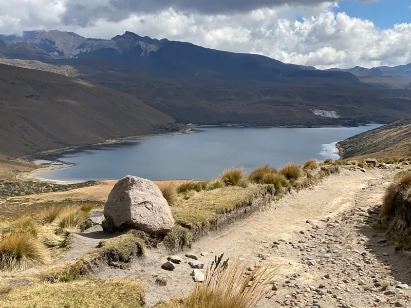
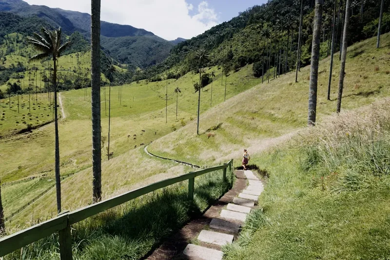
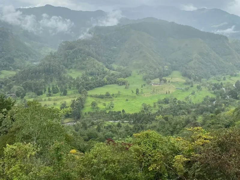
The Alto de Letras Ride-walk is a testament to the diverse topography of Colombia's central Andes. This route is famous for its relentless climb, often cited as one of the longest and most challenging ascents in the world, particularly for cyclists. For walkers, the journey is equally demanding, requiring significant physical preparation and mental fortitude. The trail begins in the verdant lower slopes, passing through coffee plantations and small rural villages where the aroma of freshly roasted beans fills the air. As you ascend, the landscape transforms dramatically. The dense cloud forests give way to open páramo, a unique high-altitude grassland ecosystem characterized by its spongy vegetation, misty conditions, and stark beauty. The air becomes thinner, the temperatures drop, and the views open up to vast, rolling hills and distant snow-capped volcanoes.
This route is not a single, clearly marked trail but a series of interconnected roads and paths. The exact path can be adapted based on preference and current conditions, offering a degree of flexibility. The primary challenge lies in the sustained elevation gain, which can be punishing. However, the rewards are immense: breathtaking panoramas, encounters with local culture, and the satisfaction of conquering a truly formidable natural obstacle. The journey is as much about the cultural immersion in the coffee-growing regions as it is about the physical challenge of reaching the high altitudes of the páramo.
The best time to undertake this journey is during the dry season, from December to February, when the chances of heavy rain are lower, and visibility is generally better. However, even in the dry season, weather in the páramo can change rapidly, with fog, wind, and cold temperatures being common. This route is best suited for experienced hikers and those with a high level of fitness, accustomed to challenging terrain and significant elevation gains.
History and Cultural Context
The region surrounding Alto de Letras has a rich history deeply intertwined with agriculture, particularly coffee cultivation, and the indigenous peoples who have inhabited these lands for centuries. The routes that now form the Alto de Letras Ride-walk were historically used by local communities for trade, travel, and accessing resources in the higher altitudes. The development of coffee farming in the late 19th and early 20th centuries transformed the economic and social landscape of the region, creating the network of roads and paths that are still in use today.
The specific challenge of "Alto de Letras" gained prominence with the rise of cycling in Colombia. It became a legendary climb, a rite of passage for serious cyclists seeking to test their mettle against one of the world's most demanding ascents. The sheer length and sustained gradient of the climb from the lower elevations to the páramo have made it a subject of fascination and a goal for many athletes. While the cycling aspect is well-documented, the walking route follows many of the same paths, offering a similar, albeit slower-paced, experience of the region's transformation.
The area is also part of the broader cultural heritage of the Eje Cafetero (Coffee Axis), a UNESCO World Heritage site. This designation recognises the unique landscape, architecture, and traditions associated with coffee production. Walking this route allows for an immersion into this living heritage, passing through traditional fincas (coffee farms) and interacting with the people who continue to cultivate this iconic Colombian product. The páramo itself holds ecological and cultural significance, with indigenous communities having long-standing relationships with these high-altitude ecosystems.
Seasonal Highlights and Weather Reality
The Alto de Letras Ride-walk is a journey through distinct climatic zones, and the experience varies significantly with the seasons.
December to February (Dry Season): This period is considered the best time for the walk. Rainfall is significantly reduced, leading to clearer skies and better visibility, especially in the páramo. The temperatures are cooler, which can be a welcome relief during the strenuous ascent. However, even in the dry season, the páramo is prone to rapid weather changes. Fog can roll in unexpectedly, reducing visibility to mere metres, and strong winds can make the exposed higher sections feel extremely cold. Mornings are often clear, but clouds can build up in the afternoon.
March to May (Rainy Season): This period sees a marked increase in rainfall. The lower slopes can become muddy and slippery, and the páramo can be shrouded in persistent mist and heavy rain. While the landscape is lush and vibrant, the conditions can be challenging for walking, with reduced visibility and increased risk of landslides or flash floods in certain areas. Temperatures remain cool, but the dampness can lead to a significant chill factor.
June to August (Transition/Drier Period): This can be a good time to walk, often offering a balance between the dry and rainy seasons. There may be occasional showers, but generally, conditions are more stable than the peak rainy months. Visibility can be good, and the landscape is still green from the earlier rains.
September to November (Rainy Season): Similar to March to May, this period is characterised by higher rainfall. The páramo can be particularly challenging, with frequent fog and cold, wet conditions. The lower sections may experience muddy trails. This is generally the least recommended time for the walk due to the persistent adverse weather.
General Weather Considerations: Regardless of the season, the páramo is an alpine environment. Temperatures can drop significantly, especially at night and at higher elevations. Hypothermia is a risk, even in warmer months, if one is not adequately prepared with warm, waterproof clothing. The altitude also plays a significant role, with thinner air requiring acclimatisation and careful pacing.
Recommended Itinerary
Alto de Letras Ride-walk: A Challenging Ascent
This itinerary is designed for a challenging 2-day walk, focusing on the ascent to the páramo. It can be adapted for a single, extremely long day for highly experienced and fit individuals, or extended with more leisurely stops in villages.
Day 1: Manizales to Los Nevados National Natural Park Entrance (or nearby village)
- Distance: Approximately 30-40 km (depending on exact start point and accommodation)
- Elevation Gain: Approximately 1,500-2,000 m
- Time: 8-10 hours
- Start Point: From Manizales city centre, take a bus or taxi towards the entrance of Parque Nacional Natural Los Nevados, near the town of La Florida or similar access point.
- Route Progression: Begin in the lower foothills, passing through coffee plantations and small rural communities. The initial part of the route is on paved or well-maintained gravel roads.
- Key Waypoints:
- Manizales (approx. 2,150 m)
- Transition from urban/suburban areas to agricultural land
- Increasingly steep gradients as you climb
- Potential stops in small villages for refreshments or lunch
- Arrival at accommodation near the park entrance (e.g., a rural finca, a small guesthouse, or a basic shelter if available).
- Notes: This day is about sustained climbing through increasingly scenic landscapes. The air will become noticeably cooler as you gain altitude. Ensure you have arranged accommodation in advance, as options can be limited.
Day 2: Los Nevados Park Entrance to Alto de Letras Summit (or highest accessible point)
- Distance: Approximately 40-50 km
- Elevation Gain: Approximately 1,680-2,180 m
- Time: 10-14 hours (or more, depending on pace and conditions)
- Start Point: Your accommodation near the Parque Nacional Natural Los Nevados entrance.
- Route Progression: The road becomes rougher, transitioning from gravel to dirt tracks, and eventually to more rugged terrain as you enter the páramo ecosystem. The vegetation changes dramatically from cloud forest to low-lying páramo grasses and shrubs.
- Key Waypoints:
- Entering the páramo zone (approx. 3,000 m+)
- Increasingly exposed sections with potential for strong winds and fog
- The iconic, winding road that characterises the Alto de Letras climb
- Reaching the summit area of Alto de Letras (approx. 3,680 m or higher, depending on the exact definition of the "summit" for the route)
- Descent: The descent is as challenging as the ascent, requiring careful footing and concentration.
- Notes: This is the most demanding day. Start very early to maximise daylight hours and potentially avoid afternoon cloud build-up. Carry ample water and high-energy food. Be prepared for extreme weather changes. The "summit" is often defined by a specific point on the road or a marker, but the highest accessible point for walking can be explored further.
Alternative 1-Day Itinerary (Extremely Challenging):
- Start from Manizales very early (e.g., 4-5 AM).
- Focus on a rapid ascent, carrying all necessary supplies.
- This requires exceptional fitness, acclimatisation, and a very early start to complete within daylight hours.
Important Considerations:
- This route is not a single, marked trail. Navigation skills and reliable GPS are essential.
- The "trail" is largely a road network, so be aware of occasional vehicle traffic, especially on lower sections.
- Accommodation options are sparse at higher altitudes; pre-booking is crucial.
- Weather is the biggest variable; be prepared for cold, rain, fog, and wind at any time.
Planning and Bookings
Book Your Trip
Everything you need to plan your journey
Accommodation
Find places to stay near Manizales
Flights
Search flights to Manizales
Essential Preparation
The Alto de Letras Ride-walk is a serious undertaking that requires meticulous planning. Given its challenging nature and remote sections, preparation is paramount. Begin by assessing your fitness level; this route demands excellent cardiovascular endurance and leg strength, as well as the ability to handle sustained climbs and descents. Acclimatisation to altitude is also crucial. If possible, spend a few days in Manizales (around 2,150 m) or a similar altitude before starting your ascent to help your body adjust to the thinner air.
Logistics involve understanding the route, which is not a single marked trail but a network of roads and tracks. Reliable GPS navigation is essential, and it's advisable to download offline maps of the area. Consider hiring a local guide, especially if you are unfamiliar with the region or the specific route. They can provide invaluable insights into local conditions, safety, and cultural nuances.
The closest major city and logistical hub is Manizales. From Manizales airport (MZL), you can take a taxi or bus to the city centre. From Manizales, local buses or taxis can take you towards the general area of the Parque Nacional Natural Los Nevados entrance, which serves as a common starting point. Road conditions can vary significantly, from paved highways to rough dirt tracks, especially as you gain altitude. Limited parking is available at the trailhead, so if you are driving, confirm parking arrangements.
Trail Accommodation
Accommodation options along the Alto de Letras Ride-walk are limited and become increasingly scarce as you ascend. The primary challenge is finding suitable places to stay, especially for a multi-day trek.
Lower Sections (Day 1):
- Rural Fincas/Guesthouses: In the lower and mid-altitude regions, particularly around coffee-growing areas, you may find small, family-run fincas that offer basic accommodation. These often provide a glimpse into local life and can serve meals. Booking in advance is highly recommended, as these are not formal hotels and may have limited capacity.
- Small Villages: Some villages along the route might have very basic hostels or rooms for rent. Availability is not guaranteed, and facilities will be rudimentary.
Higher Sections (Day 2):
- Parque Nacional Natural Los Nevados Entrance Area: There might be basic shelters or designated camping areas near the park entrance. Facilities are likely to be minimal, possibly including a basic roof, a place to pitch a tent, and perhaps a rudimentary toilet.
- Camping: For those with the necessary gear, camping is a viable option, especially in the higher páramo regions. However, be aware of the harsh weather conditions, including strong winds, cold temperatures, and potential rain. Ensure you have a robust tent suitable for alpine conditions.
What's Provided: Typically, accommodation will offer a bed or space to pitch a tent. Some fincas may provide meals (breakfast, lunch, dinner) if arranged in advance. Basic toilet facilities might be available.
What's NOT Provided: Expect no electricity, heating, running hot water, or cooking facilities at most higher-altitude locations. You will need to be entirely self-sufficient for food, water treatment, and warmth.
Seasonal Availability: While the route is technically accessible year-round, the dry season (December-February) offers the most favourable conditions for finding open accommodation and for camping. During the rainy season, some rural accommodations might be less accessible or have reduced services.
Costs: Costs can vary widely. Basic rural accommodation might range from $15-30 USD per night, with meals extra. Camping fees, if applicable, are usually nominal. It is advisable to carry sufficient cash, as card payments are unlikely to be accepted.
This is a challenging route requiring significant self-sufficiency. If no suitable overnight accommodation is available or desired, a very early start from Manizales for a single, extremely long day hike is an option for highly experienced individuals.
Required Gear
- Sturdy Hiking Boots: Waterproof, well-broken-in hiking boots with good ankle support are essential for the varied and often rough terrain.
- Waterproof and Windproof Outerwear: A high-quality waterproof and breathable jacket (e.g., Gore-Tex) and waterproof overtrousers are non-negotiable due to the unpredictable and often harsh páramo weather.
- Warm Layers: Multiple insulating layers are crucial. This includes thermal base layers (merino wool or synthetic), a fleece or down mid-layer, and a warm hat and gloves. Temperatures can drop significantly at altitude.
- Backpack: A comfortable, well-fitting backpack (40-60 litres) with a rain cover. Ensure it can carry all your gear, including extra clothing, food, and water.
- Navigation Tools: A reliable GPS device or smartphone with offline maps (e.g., Maps.me, Gaia GPS) and a compass. A physical map of the region is also recommended as a backup.
- Head Torch: With spare batteries. Essential for early starts or late finishes, and for navigating in low light conditions.
- First-Aid Kit: Comprehensive kit including blister treatment, pain relievers, antiseptic wipes, bandages, any personal medications, and altitude sickness medication if recommended by your doctor.
- Sun Protection: High SPF sunscreen, sunglasses, and a wide-brimmed hat. The sun can be intense at altitude, even on cloudy days.
- Trekking Poles: Highly recommended for stability on steep ascents and descents, and to reduce strain on knees.
What to Bring
- Food: High-energy, non-perishable food for the duration of your trek. This includes breakfast, lunch, dinner, and plenty of snacks (nuts, dried fruit, energy bars, jerky). There are very few opportunities to buy food along the route, especially at higher altitudes.
- Water Treatment: A water filter or purification tablets. While water sources may appear clean, it's always best to treat water from streams and rivers, especially in the páramo.
- Water Bottles/Hydration Reservoir: Carry at least 2-3 litres of water capacity.
- Toiletries: Biodegradable soap, toothbrush, toothpaste, hand sanitiser, and toilet paper. Pack out all used toilet paper.
- Personal Items: Camera, power bank for electronics, a small towel, insect repellent (though less of an issue at higher altitudes), and any personal comfort items.
- Emergency Shelter: A lightweight emergency bivy bag or space blanket can be a lifesaver in unexpected situations.
- Cash: Sufficient Colombian Pesos (COP) for any accommodation, food, or transport along the route. Many rural establishments do not accept credit cards.
- Duct Tape and Repair Kit: For minor gear repairs.
Permits

For the Alto de Letras Ride-walk, the primary consideration regarding permits relates to access to the Parque Nacional Natural Los Nevados. While the immediate trailhead access from Manizales might not require a specific permit for the initial road sections, entering the national park itself typically involves an entrance fee and adherence to park regulations.
Parque Nacional Natural Los Nevados Entrance Fees:
- Visitors are generally required to pay an entrance fee to access the national park. The exact cost can vary, but it is typically a modest fee per person, per day.
- It is advisable to check the official website of Parques Nacionales Naturales de Colombia (PNN) for the most up-to-date information on entrance fees, opening hours, and any specific regulations for the Los Nevados sector.
- Payment is usually made at the park's visitor centre or designated entry points. It is recommended to have cash (Colombian Pesos) available, as card facilities may not always be operational in these remote areas.
Permit Requirements for Specific Activities:
- While this route is primarily a walking/cycling path, if you plan any activities such as camping within designated park areas, or if you intend to explore off-trail routes that require special permission, you may need to obtain additional permits or authorizations from the park authorities.
- For general trekking along established roads and tracks within the park's accessible areas, the standard entrance fee usually suffices.
Booking and Reservations:
- Unlike some highly regulated trails, the Alto de Letras route does not typically require advance booking of specific hiking slots or hut reservations, especially for the walking route. The challenge lies more in finding and booking accommodation in the limited rural options available.
- However, if you plan to stay in any official park accommodation or use designated camping sites, it is wise to inquire about reservation possibilities, particularly during peak seasons.
Recommendation:
- Before your trip, visit the official website of Parques Nacionales Naturales de Colombia (PNN) and search for information on Parque Nacional Natural Los Nevados. Look for sections on visitor information, fees, and regulations.
- Contacting the park's administrative office or visitor centre in Manizales or a nearby town a few days before your trek can provide the most current and accurate information regarding permits and fees.
Other Activities in the Area
The region around Manizales and the Parque Nacional Natural Los Nevados offers a wealth of activities beyond the Alto de Letras Ride-walk:
- Coffee Plantation Tours: Immerse yourself in the heart of Colombia's coffee culture. Many fincas offer guided tours where you can learn about the entire coffee-making process, from bean to cup, and enjoy tastings.
- Thermal Springs: The volcanic activity in the region feeds numerous natural hot springs. Places like Termales El Otoño or Termales Santa Rosa de Cabal (a bit further afield but accessible) offer relaxing experiences amidst stunning natural scenery.
- Hiking in Los Nevados National Natural Park: Beyond the Alto de Letras route, the park offers numerous other hiking opportunities. Trails lead to volcanic peaks like Nevado del Ruiz (access may be restricted due to volcanic activity), Nevado de Santa Isabel, and Nevado del Tolima, offering glacier trekking and high-altitude mountaineering for experienced individuals.
- Birdwatching: The diverse ecosystems, from cloud forests to páramo, are home to an incredible array of bird species, including many endemic to Colombia.
- Exploring Manizales: The city itself is worth exploring, with its colonial architecture, vibrant markets, and the iconic Catedral Basílica Metropolitana de Nuestra Señora del Rosario.
- Adventure Sports: The mountainous terrain is ideal for paragliding, canyoning, and white-water rafting on nearby rivers.
- Visiting Nearby Towns: Explore charming towns in the Coffee Axis like Salento, Filandia, or Pijao, known for their colourful architecture, traditional ways of life, and beautiful landscapes.
Safety and Conditions
Altitude Sickness (Soroche): This is a significant risk on the Alto de Letras. Symptoms can include headache, nausea, dizziness, and fatigue. Acclimatisation is the best prevention. If symptoms occur, descend to a lower altitude. Stay hydrated and avoid alcohol and strenuous activity on your first day at altitude.
Weather: The páramo environment is notorious for its unpredictable and rapidly changing weather. Be prepared for cold temperatures (potentially near freezing), strong winds, heavy rain, fog, and even snow at higher elevations. Hypothermia is a serious risk. Always carry adequate warm and waterproof clothing, even if the forecast is good.
Navigation: As this is not a marked trail, reliable navigation is critical. GPS devices or smartphone apps with offline maps are essential. Inform someone of your planned route and expected return time. Consider hiring a local guide for added safety and local knowledge.
Road Conditions: While the lower sections may be paved or well-maintained gravel, higher sections can be rough, muddy, and prone to erosion, especially after rain. Be aware of occasional vehicle traffic, particularly on the lower parts of the route.
Water Sources: Water is generally available from streams and rivers, but it should always be treated (filtered or purified) to avoid waterborne illnesses.
Wildlife: While large dangerous animals are rare, be aware of your surroundings. Venomous snakes are uncommon at high altitudes but can be present in lower, warmer areas. Respect any wildlife you encounter.
Communication: Mobile phone signal is unreliable and often non-existent at higher altitudes. Consider carrying a satellite communication device (like a SPOT or Garmin inReach) for emergencies.
Emergency Services: Emergency services in remote mountainous areas can be slow to respond. Having a personal locator beacon (PLB) or satellite messenger is highly recommended. Know the emergency contact numbers for the region and the national park authorities.
Physical Fitness: This route is extremely demanding. Ensure you are in excellent physical condition and have experience with multi-day hikes and significant elevation gains before attempting it.
Side Trips and Points of Interest
While the Alto de Letras Ride-walk itself is a significant undertaking, the surrounding region offers several points of interest and potential side trips:
Nevado del Ruiz National Natural Park: Although access to the summit of Nevado del Ruiz may be restricted due to its active volcanic status, the surrounding park offers stunning páramo landscapes and opportunities for high-altitude trekking. Check current park regulations and access status before planning a visit. The views of the volcano from various points along the Alto de Letras route can be spectacular on clear days.
Nevado de Santa Isabel: This is one of the more accessible snow-capped peaks within the Los Nevados National Natural Park. Guided ascents are possible for those with mountaineering experience and appropriate gear, offering a chance to walk on glaciers and experience a true high-Andean environment. The views from its summit are breathtaking.
Laguna del Otún: A beautiful high-altitude lake located within the Los Nevados National Natural Park. It's a popular spot for trout fishing (permits may be required) and offers serene scenery amidst the páramo. Access typically involves a hike from a designated starting point.
Traditional Coffee Fincas: Many fincas along the lower and mid-sections of the route offer more than just accommodation. They are living museums of coffee culture. Taking a detailed tour, participating in a coffee tasting, and learning about the sustainable practices employed by local farmers can be a deeply enriching experience.
Local Villages: Small villages like La Florida or others encountered along the route offer a glimpse into rural Colombian life. Stopping for a local meal, interacting with residents, and observing the daily routines can provide valuable cultural insights.
Miradores (Viewpoints): Numerous unofficial viewpoints along the winding roads of Alto de Letras offer spectacular panoramas of the valleys below and the surrounding Andean peaks. These are perfect spots for photography and to appreciate the sheer scale of the climb.
Leave No Trace
The Alto de Letras Ride-walk traverses fragile ecosystems, from the lush coffee-growing regions to the delicate páramo. Adhering to Leave No Trace principles is crucial to preserving these environments for future generations and for the local communities who depend on them.
Plan Ahead and Prepare: Research your route thoroughly, understand the conditions, and be prepared for all types of weather. Pack appropriately to minimise waste and ensure you have the means to carry out everything you bring in.
Travel and Camp on Durable Surfaces: Stick to established roads and tracks. In the páramo, walk on the vegetation itself rather than creating new paths, as the plant life is slow-growing and easily damaged. If camping, choose established sites or areas where impact will be minimal.
Dispose of Waste Properly: Pack out everything you pack in, including all food scraps, wrappers, and toilet paper. Use designated toilets where available. If no facilities exist, dig catholes at least 60 metres away from water sources, trails, and campsites. Pack out all toilet paper.
Leave What You Find: Do not disturb plants, rocks, or historical artefacts. Take only photographs and memories.
Minimise Campfire Impacts: Campfires are generally not recommended or permitted in the páramo due to the fragile vegetation and high risk of uncontrolled spread. Use a portable stove for cooking.
Respect Wildlife: Observe wildlife from a distance. Do not feed animals, as this can disrupt their natural behaviours and diets. Store food securely to prevent attracting animals.
Be Considerate of Other Visitors: Keep noise levels down, especially in rural communities and natural areas. Yield to other hikers and cyclists on the trail. Respect local customs and traditions.
The páramo ecosystem is particularly sensitive. Its unique vegetation plays a vital role in water regulation and carbon sequestration. Tread lightly and with respect.