Dolomites Alta Via 2 - The High Way of the Legends
The Dolomites Alta Via 2 (AV2) is widely considered the most spectacular and physically demanding of the high-altitude routes traversing the Italian Dolomites. Stretching approximately 160 kilometres from the historic town of Brixen (Bressanone) in the north to the ancient city of Feltre in the south, this "High Way" is a journey through a landscape of staggering geological drama. Unlike its gentler sibling, the Alta Via 1, the AV2 stays consistently higher, crosses more rugged terrain, and involves significant technical challenges, including steep scree slopes, exposed ridgelines, and several "sentieri attrezzati" (aided paths) equipped with fixed steel cables. It is a route that demands respect, high levels of fitness, and a steady head for heights, rewarding the intrepid trekker with unparalleled views of the Sella Group, the Marmolada glacier, and the jagged spires of the Pale di San Martino.
- Distance: 160.0 km point-to-point
- Duration: 10–13 days
- Total Elevation Gain: 12,000 m
- Difficulty: Very Challenging (includes technical alpine terrain and via ferrata)
- Highest Point: Forcella Pordoi (2,844 m) or Piz Boè (3,152 m) as an optional peak
- Best Time: July to September
- Accommodation: High-altitude mountain huts (Rifugi)
- Closest City: Bolzano (Bozen)
Overview
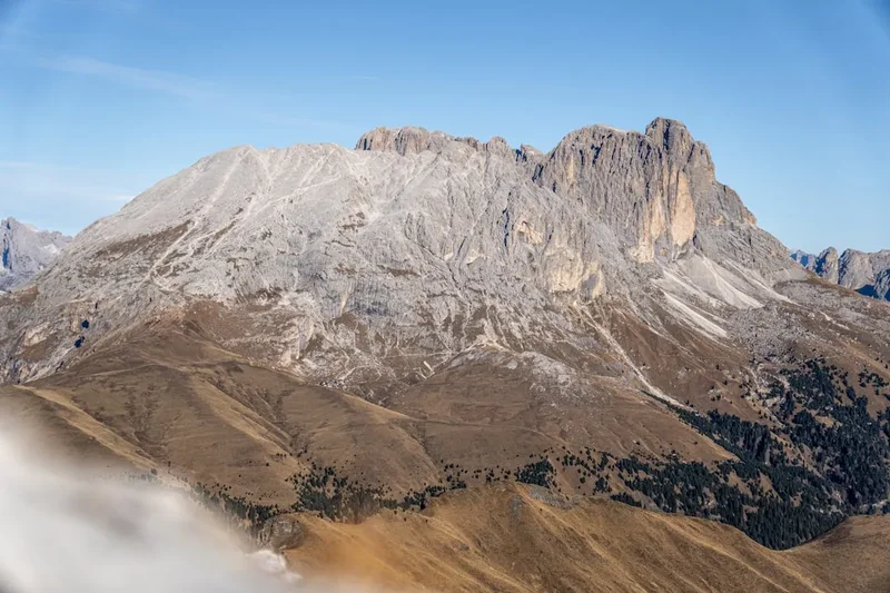
The Alta Via 2 is often referred to as the "Via delle Leggende" (Way of the Legends), a name that reflects the deep mythological roots of the Ladin people who inhabit these valleys. The trail is a masterclass in alpine variety. It begins in the lush, rolling meadows of the Plose above Brixen, quickly transitioning into the sharp, pale limestone needles of the Odle and Puez groups. As the journey progresses, the landscape becomes increasingly lunar and austere. The crossing of the Sella Massif—a vast, high-altitude plateau—feels like stepping onto another planet, while the descent toward the Marmolada offers views of the only remaining glacier in the Dolomites. The final stages through the Pale di San Martino and the Vette Feltrine are remote, wild, and physically punishing, featuring some of the most sustained elevation changes on the entire route.
Physically, the AV2 is a relentless undertaking. With 12,000 metres of ascent and nearly as much descent, hikers must be prepared for daily climbs of 1,000 metres or more, often on unstable terrain. The "Dolomite scree"—fine, loose limestone gravel—is a constant companion, making descents particularly taxing on the knees and concentration. Furthermore, the route includes several sections where fixed cables are provided for safety. While many experienced hikers complete these without full via ferrata equipment in perfect weather, a harness, lanyard, and helmet are strongly recommended, especially for the crossing of the Sella Group and the technical sections in the Pale di San Martino. This is not merely a walk; it is a high-alpine adventure that requires a solid understanding of mountain weather, navigation, and personal physical limits.
The reward for this exertion is a stay in the legendary Italian Rifugi. These mountain huts, perched on improbable ridges or nestled in high cirques, provide a unique cultural experience. After a day of intense physical effort, hikers are greeted with warm hospitality, hearty South Tyrolean and Trentino cuisine, and the camaraderie of fellow trekkers from around the world. Watching the "Enrosadira"—the phenomenon where the limestone peaks turn a brilliant shade of pink and orange at sunset—from the terrace of a hut at 2,500 metres is an experience that defines the magic of the Dolomites. The Alta Via 2 is a journey of endurance, but it is equally a journey of profound beauty and cultural immersion.
History and Cultural Context
The Dolomites are a UNESCO World Heritage site, recognised not only for their exceptional natural beauty but also for their unique geological history. These mountains were formed 250 million years ago as coral reefs in the ancient Tethys Ocean. The distinctive pale rock, a magnesium-rich limestone known as dolomite, was named after the French mineralogist Déodat Gratet de Dolomieu, who first described it in the late 18th century. Walking the AV2 is, in many ways, a walk across an ancient seabed that has been thrust into the sky by tectonic forces.
Culturally, the route traverses three distinct Italian provinces: South Tyrol (Alto Adige), Trentino, and Belluno. In the northern sections, the influence of Austrian heritage is palpable. German is the primary language, and the architecture and food reflect a Tyrolean character. As you move south, the culture shifts toward a more traditionally Italian feel. However, the heart of the Dolomites is the Ladin culture. The Ladin people are a Rhaeto-Romance ethnic group who have lived in these isolated valleys for millennia, preserving their own unique language and traditions. Many of the peaks and passes along the AV2 carry Ladin names, and the "legends" of the route often involve the mythical Kingdom of the Fanes and the spirits that inhabit the crags.
The 20th-century history of the region is more somber. During the First World War, the Dolomites were the front line of a brutal conflict between the Austro-Hungarian Empire and the Kingdom of Italy. Known as the "White War," soldiers fought not only each other but also the extreme cold and avalanches. While the AV2 does not pass through the most famous open-air museums of the war (which are closer to the Alta Via 1), the legacy of the conflict is visible in the very paths you walk. Many of the trails and via ferrata routes were originally constructed by soldiers to move troops and supplies through the vertical landscape. Today, these paths serve as a bridge between a violent past and a peaceful present, allowing hikers to explore terrain that was once inaccessible.
Want more background? Read extended notes on history and cultural context → Learn more
Seasonal Highlights and Weather Reality
The window for hiking the Alta Via 2 is relatively short, typically spanning from late June to late September. Outside of this period, high-altitude passes are often blocked by snow, and the majority of the Rifugi are closed. Even within the summer season, weather in the Dolomites is notoriously volatile and can change from brilliant sunshine to a violent thunderstorm within thirty minutes.
Early Season (Late June to Mid-July): This is a beautiful time to visit, as the alpine meadows are in full bloom and the days are at their longest. However, snow often lingers on the higher passes (such as Forcella del Mesdì or the Val de Mezdi). Hikers in early July should be prepared for snow crossings and may require micro-spikes or an ice axe depending on the previous winter's snowfall. The weather is generally stable in the mornings, with a high probability of afternoon "temporali" (thunderstorms).
High Summer (Late July to August): This is the peak season. The weather is at its warmest, and all snow has usually melted from the trails. This is also the busiest time, with huts often booked out months in advance. August brings the highest risk of heat-induced afternoon thunderstorms, which can be dangerous if you are caught on an exposed ridgeline or a via ferrata cable. It is essential to start your days early to be off the high ground by 2:00 PM.
Late Season (September): Many experienced hikers consider September the best month for the AV2. The air is crisper and clearer, providing the best visibility for photography. The crowds of August have dissipated, and the weather is often more stable, with fewer afternoon storms. However, the days are shorter, and the first dustings of autumn snow can occur on the higher peaks. Most huts close by the third or fourth week of September, so careful planning is required.
Recommended Itinerary

11-Day Alta Via 2 Itinerary
Day 1: Brixen (Bressanone) to Rifugio Genova
- Distance: 15 km
- Elevation gain: 1,200 m
- Time: 6–7 hours
- Take the Plose gondola from S. Andrea to save 1,000 m of initial climbing
- Walk across the grassy ridges of the Plose with views of the Odle Group
- Descend to Passo delle Erbe and climb toward the Forcella de Putia
- Arrive at Rifugio Genova (Schlüterhütte), situated in a beautiful alpine saddle
- A moderate start to the trek, allowing for acclimatisation
Day 2: Rifugio Genova to Rifugio Puez
- Distance: 15 km
- Elevation gain: 850 m
- Time: 6 hours
- Cross the spectacular Bronsoi ridge
- Traverse the high-altitude meadows of the Puez-Odle Nature Park
- Pass through the Forcella della Roa (steep scree)
- Arrive at Rifugio Puez, a remote hut located on a stark limestone plateau
- The landscape begins to shift from green meadows to grey dolomite rock
Day 3: Rifugio Puez to Rifugio Pisciadù
- Distance: 12 km
- Elevation gain: 800 m
- Time: 6–7 hours
- Descend to Passo Gardena, a busy mountain pass road
- Ascend the Val Setus—a very steep, cable-aided gully (technical section)
- Alternatively, take the Via Ferrata Brigata Tridentina (requires full gear and experience)
- Arrive at Rifugio Pisciadù, perched next to a turquoise glacial lake
- One of the most iconic and technical days of the northern section
Day 4: Rifugio Pisciadù to Rifugio Castiglioni Marmolada
- Distance: 16 km
- Elevation gain: 750 m
- Time: 7–8 hours
- Cross the heart of the Sella Massif, a vast lunar landscape
- Optional ascent of Piz Boè (3,152 m), the highest peak in the Sella Group
- Descend the long, steep path to Passo Pordoi and then to Passo Fedaia
- Arrive at Rifugio Castiglioni, located at the base of the Marmolada glacier
- Spectacular views of the "Queen of the Dolomites" (Marmolada)
Day 5: Rifugio Castiglioni to Rifugio Fuciade
- Distance: 14 km
- Elevation gain: 700 m
- Time: 5–6 hours
- Walk along the "Sentiero del Pan" (Bread Path) with constant views of the glacier
- Descend to Passo Fedaia and then climb toward Passo San Pellegrino
- Arrive at Rifugio Fuciade, famous for its exceptional gourmet cuisine
- A slightly easier day physically, providing a much-needed recovery period
Day 6: Rifugio Fuciade to Rifugio Mulaz
- Distance: 14 km
- Elevation gain: 1,100 m
- Time: 7 hours
- Climb steeply to the Passo delle Selle
- Traverse high ridges with views of the Pale di San Martino
- Final steep ascent to the Passo di Mulaz
- Arrive at Rifugio Mulaz, tucked beneath the towering peaks of the northern Pale
- The entry into the wild and rugged Pale di San Martino group
Day 7: Rifugio Mulaz to Rifugio Rosetta
- Distance: 8 km
- Elevation gain: 700 m
- Time: 5 hours
- A shorter but very technical day involving the "Sentiero delle Farangole"
- Includes cable-aided sections and steep, exposed traverses
- Cross the Passo delle Farangole (2,814 m)
- Arrive at Rifugio Rosetta, situated on the vast, desert-like Pale Plateau
- The plateau is often shrouded in mist, requiring careful navigation
Day 8: Rifugio Rosetta to Rifugio Pradidali
- Distance: 7 km
- Elevation gain: 500 m
- Time: 4–5 hours
- Traverse the southern edge of the Pale Plateau
- Descend a steep, cable-aided path into the dramatic Pradidali cirque
- Arrive at Rifugio Pradidali, surrounded by vertical limestone walls
- Short distance but high intensity and incredible photography opportunities
Day 9: Rifugio Pradidali to Rifugio Treviso
- Distance: 13 km
- Elevation gain: 800 m
- Time: 7 hours
- Descend into the Val Canali, one of the most beautiful valleys in the Dolomites
- Climb steeply back up through dense forest and scree to the Val di Roda
- Arrive at Rifugio Treviso, a traditional hut in a deep, forested valley
- A day of massive elevation changes and varied ecosystems
Day 10: Rifugio Treviso to Rifugio Boz
- Distance: 16 km
- Elevation gain: 1,200 m
- Time: 8 hours
- The most remote and wild section of the trek
- Cross the Passo del Coro (technical, cable-aided section)
- Traverse the Vette Feltrine, a less-visited but stunning mountain range
- Arrive at Rifugio Boz, located in a peaceful alpine basin
- Requires high endurance and self-sufficiency
Day 11: Rifugio Boz to Feltre
- Distance: 18 km
- Elevation gain: 600 m (but 2,000 m of descent)
- Time: 7–8 hours
- Final traverse of the Vette Feltrine ridges
- Pass the Rifugio Dal Piaz for a final mountain coffee
- Long, knee-punishing descent to Passo Croce d'Aune and finally Feltre
- Celebrate the completion of the AV2 in the historic centre of Feltre
Planning and Bookings
Book Your Trip
Everything you need to plan your journey
Accommodation
Find places to stay near Bolzano
Flights
Search flights to Bolzano
Essential Preparation
The Alta Via 2 is a serious undertaking that requires significant physical and logistical preparation. Unlike many lower-altitude treks, the AV2 involves technical terrain where a simple slip can have serious consequences. Prospective hikers should have experience in mountain navigation, be comfortable with exposure (heights), and possess the fitness to carry a 10–12 kg pack for 6–8 hours a day over multiple days of 1,000 m+ elevation gain.
Logistically, the trek begins in Brixen (Bressanone), which is easily reached by train from Bolzano, Innsbruck, or Verona. Most hikers fly into Venice (VCE), Verona (VRN), or Munich (MUC). It is highly recommended to spend at least one night in Brixen before starting to finalise gear and adjust to the altitude. Coordination of hut bookings is the most critical part of preparation; the route is popular, and the huts have limited capacity.
Trail Accommodation
Accommodation on the Alta Via 2 is exclusively in Rifugi (mountain huts). These range from large, hotel-like structures at mountain passes to small, remote outposts perched on rocky ledges. Most are operated by the Club Alpino Italiano (CAI) or are privately owned.
Hut Facilities:
- Sleeping arrangements: Usually a mix of "camerate" (large dormitories with 10–20 bunks) and smaller 4–6 person rooms.
- Bedding: Mattresses, pillows, and heavy blankets are provided. A lightweight silk or cotton sleeping bag liner is mandatory for hygiene.
- Food: Most hikers opt for "Mezza Pensione" (Half Board), which includes a three-course dinner and breakfast. Lunch packets can be purchased.
- Water: Potable water is usually available, though in some high-altitude huts (like Rosetta), water is scarce and must be purchased in bottles.
- Showers: Most huts have hot showers available for a small fee (usually €3–€5 for a 3-minute token).
- Electricity: Available for charging devices in common areas, though outlets are often in high demand.
Booking Requirements:
- Bookings should be made 4–6 months in advance for the peak July–August season.
- Many huts can now be booked through the "Rifugionline" portal or via their individual websites/email.
- A deposit is often required to secure a booking.
- Costs: Expect to pay €60–€90 per night for half-board. CAI members receive significant discounts (up to 50%) on the lodging portion of the cost.
Required Gear
- Footwear: High-quality trekking boots with stiff soles and excellent ankle support. Trail runners are not recommended for the AV2 due to the sharp limestone and heavy scree.
- Via Ferrata Kit: A climbing harness, via ferrata lanyard (with shock absorber), and a climbing helmet. Even if you are an experienced hiker, these are essential for safety on the Sella and Pale sections.
- Backpack: A 35–45 litre pack is ideal. Ensure it has a high-quality hip belt and a rain cover.
- Clothing: A layering system is essential. Include a waterproof/breathable shell (Gore-Tex), a down or synthetic puffer jacket for cold evenings, and moisture-wicking base layers.
- Navigation: Offline GPS maps (e.g., Gaia GPS or AllTrails) and a physical Tabacco map (Sheets 030, 07, 015, 022, 023).
- Safety: A basic first aid kit, an emergency bivy bag, and a whistle.
What to Bring
- Sleeping bag liner: Silk is lightest and most compact.
- Cash: Many remote huts do not accept credit cards or have unreliable connections. Carry enough Euros for lunches, showers, and drinks.
- Earplugs and eye mask: Essential for sleeping in crowded dormitories.
- Personal toiletries: Biodegradable soap, travel towel, and sun protection (SPF 50+ is vital at high altitude).
- Water treatment: While hut water is usually safe, a lightweight filter or tablets are useful for emergency refills from streams.
- Snacks: High-energy bars, nuts, and dried fruit. While huts provide food, you will need fuel between stops.
- Power bank: To ensure your phone/GPS remains charged when hut outlets are full.
Permits
One of the advantages of the Alta Via 2 is that there is no official "permit" required to hike the trail itself. Access to the Dolomites UNESCO World Heritage area is free and open to the public. However, the "permit" in a practical sense is your hut reservation. Because wild camping is strictly prohibited in most of the Dolomites (especially within Nature Parks), you must have a confirmed bed in a Rifugio or a designated campsite (which are rare on the AV2) for every night of your journey.
Booking Strategy:
- Start planning in January or February for a summer trek.
- Identify the "bottleneck" huts—Rifugio Pisciadù, Rifugio Rosetta, and Rifugio Mulaz are often the first to fill up.
- If a hut is full, look for alternative routes or nearby huts (e.g., Rifugio Boe instead of Pisciadù), though this may add distance or technicality to your day.
- Consider joining a national alpine club (like CAI, DAV, or AAC). Not only does this provide insurance and hut discounts, but it also supports the maintenance of the trail system.
Logistical Costs:
- Gondolas: Using lifts like the Plose or Rosetta cable cars can cost €15–€25 per trip but save thousands of metres of vertical climbing.
- Transport: Regional buses (SAD in South Tyrol) are efficient and affordable. A "Mobilcard" can provide unlimited travel for several days.
Other Activities in the Area
The Dolomites offer a wealth of experiences beyond the Alta Via 2. Consider adding a few days to your itinerary to explore:
- Via Ferrata: The Dolomites are the birthplace of via ferrata. If you have the gear and experience, consider dedicated days for famous routes like the "Oskar Schuster" on the Sassolungo or the "Bolver-Lugli" in the Pale di San Martino.
- Bolzano (Bozen): A beautiful bilingual city. Visit the South Tyrol Museum of Archaeology to see "Ötzi the Iceman," a 5,300-year-old mummy found in a nearby glacier.
- Wine Tasting: The valleys around Brixen and Bolzano produce world-class white wines (Kerner, Sylvaner) and unique reds (Lagrein).
- Lake Braies (Pragser Wildsee): Although not on the AV2, this iconic turquoise lake is the starting point of the Alta Via 1 and is worth a day trip for its stunning beauty.
- Venice: Many hikers finish in Feltre and take a direct train (approx. 2 hours) to Venice for a celebratory end to their trip.
Safety and Conditions
The Alta Via 2 is a high-alpine route that presents genuine hazards. Safety should be your primary concern throughout the trek.
Thunderstorms (Temporali): These are the greatest objective danger in summer. Lightning strikes on exposed ridges or via ferrata cables can be fatal. Always check the local "Meteo" forecast (Arpa Veneto or Meteo Alto Adige) before departing. If storms are predicted for the afternoon, start at dawn and aim to be at your destination or below the treeline by 1:00 PM.
Exposure and Vertigo: Several sections of the AV2 involve walking along narrow ledges with significant drops. If you suffer from severe vertigo, this route may not be suitable. Always use the provided cables, even if the terrain looks "easy," as a sudden gust of wind or a slip on loose gravel can be disastrous.
Snow and Ice: In early July or after a late-season storm, snow can make the steep gullies (like Val Setus) extremely dangerous. Do not hesitate to turn back or take a lower-level valley alternative if conditions exceed your equipment or skill level.
Emergency Services: The emergency number in Italy is 112. Mountain rescue (Soccorso Alpino) is highly professional but can be expensive if you do not have insurance. Ensure your travel insurance specifically covers "mountain search and rescue" and "high-altitude trekking."
Side Trips and Points of Interest
Piz Boè (3,152 m): On Day 4, instead of bypassing the peak, take the trail to the summit of Piz Boè. It is the easiest 3,000-metre peak in the Dolomites and offers a 360-degree panorama that includes the Marmolada, the Grossglockner in Austria, and the distant Ortler Alps.
The Marmolada Glacier: While the AV2 stays on the northern side of the Fedaia valley, taking a morning to ride the "basket lift" (if operational) or the cable car from Malga Ciapela to the top of the Marmolada provides a sobering look at the retreating glacier and a visit to the highest museum in Europe (dedicated to WWI).
The Pale Plateau: Spend an extra night at Rifugio Rosetta to explore the Pale di San Martino plateau. This 50-square-kilometre karst wasteland is unlike anything else in Europe—a silent, stone desert that feels like the surface of the moon.
Vette Feltrine: The final days of the AV2 pass through the Belluno Dolomites National Park. This area is a botanical paradise, home to rare alpine flowers that survived the last ice age on these "nunataks" (peaks that remained above the ice).
Leave No Trace
The Dolomites are a fragile ecosystem under increasing pressure from tourism. As a hiker on the Alta Via 2, you have a responsibility to minimise your impact.
- Pack it out: There is no rubbish collection in the high mountains. Any trash you create (including fruit peels and tissues) must be carried down to the valleys.
- Stay on the path: Short-cutting switchbacks causes massive erosion, especially in the loose limestone soil of the Dolomites.
- Respect the wildlife: You may encounter chamois, marmots, and even the rare ibex. Observe them from a distance and never offer food.
- No wild camping: This is strictly enforced. It protects the water sources and prevents the disturbance of nocturnal wildlife.
- Water conservation: Huts often rely on meltwater or small springs. Use water sparingly for washing.