Aletsch Glacier Panorama Trail
The Aletsch Glacier Panorama Trail is a spectacular day walk in the Swiss Alps, offering unparalleled views of the largest glacier in the Alps, the Great Aletsch Glacier. This well-maintained trail winds its way along the southern flank of the glacier, providing breathtaking vistas of its immense ice flow, surrounding snow-capped peaks, and the deep valleys below. It's a relatively accessible route, making it a popular choice for hikers seeking dramatic alpine scenery without extreme technical difficulty. The trail is part of a larger network of paths in the Jungfrau-Aletsch UNESCO World Heritage region, renowned for its dramatic glacial landscapes and pristine mountain environment.
- Distance: 12.0 km
- Elevation Gain: 500 m
- Duration: 4-5 hours
- Difficulty: Moderate
- Best Time: June to October
- Closest City: Brig
- Trailhead Access: Nearest airport: Zurich (ZRH). Train to Brig, then bus to Bettmeralp (cable car access). Car: Drive to Betten Talstation, park, take cable car to Bettmeralp. Road conditions: Good, maintained roads. Parking available at Betten Talstation (fee). No permits needed. Bettmeralp coordinates: 46.414722, 8.042778.
- Coordinates: 46.4550, 8.0250
Overview
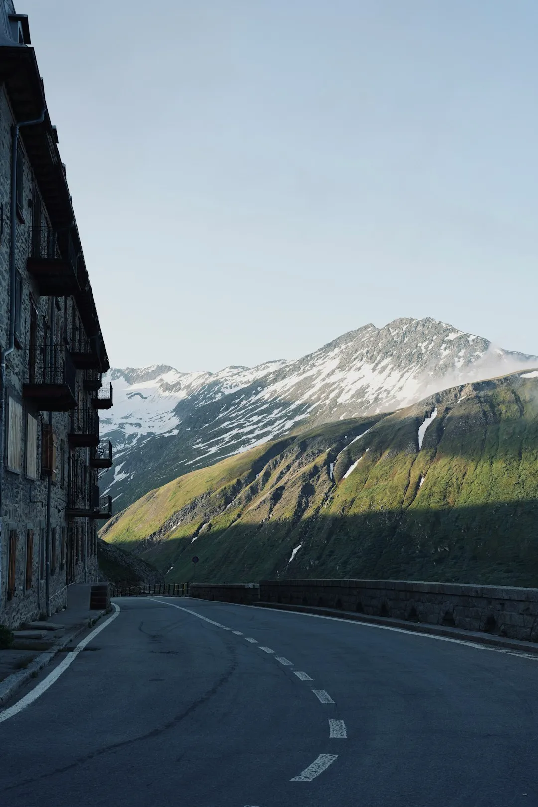
The Aletsch Glacier Panorama Trail is a quintessential alpine experience, showcasing the raw power and majestic beauty of glacial landscapes. The walk typically begins from the car-free village of Bettmeralp, accessible via a scenic cable car ride from Betten Talstation. From Bettmeralp, the trail ascends gradually, offering increasingly expansive views of the Aletsch Glacier. The path is generally well-trodden and clearly marked, though sections can be rocky and uneven, requiring sturdy footwear.
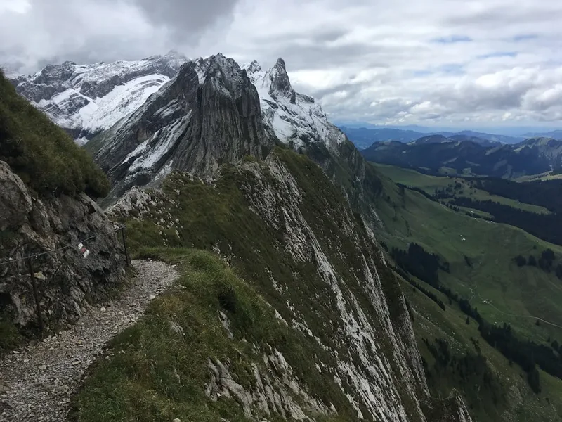
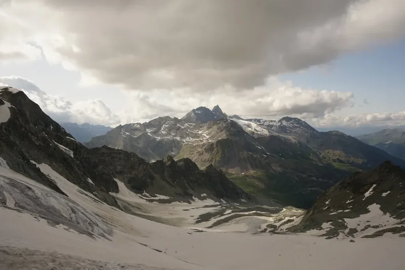
As you progress, the sheer scale of the glacier becomes apparent. It stretches for approximately 23 kilometres, a vast river of ice carving its way through the Bernese Alps. The trail often hugs the ridgeline, providing panoramic vistas that include iconic peaks such as the Eiger, Mönch, and Jungfrau in the distance, as well as the Matterhorn on clear days. The air is crisp and clean, and the silence is broken only by the occasional sound of cowbells or the distant rumble of ice shifting within the glacier.
The trail is designed to offer a continuous spectacle of the glacier's features: crevasses, seracs, and the moraines that mark its edges. Interpretive signs along the route provide fascinating insights into the glacier's formation, its retreat due to climate change, and the unique flora and fauna that have adapted to this high-alpine environment. The moderate difficulty level makes it accessible to a wide range of hikers, provided they are reasonably fit and prepared for mountain conditions. The journey culminates at a viewpoint offering a final, awe-inspiring perspective before descending back towards Bettmeralp or continuing on to other connected trails.
History and Cultural Context
The Aletsch Glacier, and the surrounding region, has a long history intertwined with human interaction and scientific observation. For centuries, the local communities in the valleys below, such as those in the Rhone Valley and the Upper Valais, have lived in the shadow of this immense ice mass. The glacier has shaped the landscape, influencing settlement patterns, agriculture, and local folklore. Early inhabitants likely viewed the glacier with a mixture of awe and trepidation, a powerful force of nature that could both sustain and threaten their existence.
The scientific exploration of the Alps, particularly the study of glaciers, gained momentum in the 19th century. Mountaineers and geologists began to systematically map and study the Aletsch Glacier, documenting its size, movement, and the impact of its meltwater on the surrounding environment. Figures like Louis Agassiz, a Swiss geologist and glaciologist, conducted groundbreaking research that helped establish the field of glaciology and highlighted the dynamic nature of glaciers. The establishment of mountain huts and the development of hiking trails in the late 19th and early 20th centuries opened up these remote areas to a wider public, fostering a greater appreciation for their natural beauty and scientific significance.
The designation of the Jungfrau-Aletsch-Bietschhorn region as a UNESCO World Heritage site in 2001 was a testament to its outstanding universal value, recognising its exceptional glacial landscapes, its importance for understanding geological processes, and its unique biodiversity. The Aletsch Glacier Panorama Trail is part of this protected area, and its existence is a result of efforts to balance tourism with conservation, allowing visitors to experience the grandeur of the glacier while respecting its fragile ecosystem. The ongoing monitoring of the glacier's retreat due to climate change has added a contemporary layer to its history, transforming it into a visible symbol of global environmental challenges.
Seasonal Highlights and Weather Reality
The Aletsch Glacier Panorama Trail is best enjoyed during the warmer months, typically from June to October. During this period, the snow has largely melted from the higher sections of the trail, and the weather is generally more stable, although alpine conditions can change rapidly.
Spring (June): As the snow recedes, the landscape begins to awaken. Wildflowers start to bloom, adding splashes of colour to the alpine meadows. The glacier itself is still impressive, with its winter snowpack gradually melting. However, early June can still see lingering snow patches on shaded sections of the trail, and some higher mountain huts or cable car services might not yet be fully operational. The weather can be unpredictable, with a risk of late snowfalls.
Summer (July-August): This is peak season for hiking in the Alps. The days are long, and the weather is often at its most favourable, with warm temperatures and clear skies. The Aletsch Glacier is fully accessible, and the panoramic views are at their most spectacular. This is also the busiest time, so expect more fellow hikers on the trail and at popular viewpoints. Sandflies are generally not a significant issue in this high-alpine environment, unlike in some other mountainous regions.
Autumn (September-October): Autumn offers a different kind of beauty. The foliage in the lower valleys turns golden and red, creating a stunning contrast with the white of the glacier and the grey of the rocks. The air is often crisp and clear, offering excellent visibility for distant mountain views. The crowds thin out considerably, providing a more tranquil hiking experience. However, temperatures begin to drop, and the possibility of early snow increases, especially in late October. Cable cars and some facilities may begin to reduce their operating hours or close for the season.
Weather Reality: It is crucial to remember that this is a high-alpine environment. Even in summer, weather can change dramatically and without warning. Sudden storms, fog, strong winds, and even snow can occur. Temperatures can drop significantly, especially at higher elevations and in the shade. Always check the weather forecast before setting out and be prepared for a range of conditions, including cold and wet weather, even on a seemingly clear day.
Recommended Itinerary
Aletsch Glacier Panorama Trail - Day Walk Itinerary
Early Morning: Arrival in Bettmeralp
- Travel to Betten Talstation (valley station).
- Park your car or arrive by public transport.
- Take the cable car up to Bettmeralp (approx. 10-minute ride).
- Enjoy the initial views of the surrounding peaks as you ascend.
- Bettmeralp is a charming, car-free village, a perfect starting point.
Morning: Trailhead and Initial Ascent
- From Bettmeralp, follow signs towards the Aletsch Glacier Panorama Trail (Aletsch Panoramaweg).
- The trail begins with a gentle ascent through alpine meadows and sparse pine forests.
- The first glimpses of the Aletsch Glacier will start to appear, building anticipation.
- The path is well-marked and generally easy to follow.
- Approximate distance covered: 3-4 km.
- Approximate time taken: 1-1.5 hours.
Midday: Glacier Views and Ridge Walking
- The trail opens up onto the ridge, offering expansive and continuous views of the Great Aletsch Glacier.
- Walk along the southern flank of the glacier, with the ice flow stretching out before you.
- Key viewpoints and rest stops will be encountered, perfect for photography and enjoying the scenery.
- You will pass by information boards detailing the glacier's history and ecology.
- The terrain becomes more exposed, with rocky sections and some steeper climbs.
- Approximate distance covered: 4-5 km.
- Approximate time taken: 1.5-2 hours.
Afternoon: Reaching the Summit Viewpoint and Descent
- Continue along the panorama trail, aiming for a prominent viewpoint or a designated endpoint (e.g., Eggishorn cable car station area, depending on the exact route taken).
- Enjoy the final, most dramatic vistas of the glacier and surrounding peaks.
- Begin your descent, which may involve following the same path back or taking a slightly different route depending on your chosen endpoint.
- The descent can be steep in places, so take care with your footing.
- Approximate distance covered: 3-4 km.
- Approximate time taken: 1-1.5 hours.
Late Afternoon: Return to Bettmeralp
- Arrive back in Bettmeralp.
- Take the cable car back down to Betten Talstation.
- Continue your journey from Betten Talstation.
Important Notes:
- This is a day hike; no overnight accommodation is required on the trail itself.
- The trail is well-signposted, but carrying a map or using a GPS device is recommended.
- Wear sturdy hiking boots with good ankle support.
- Carry plenty of water and snacks, as facilities on the trail are limited.
- Be prepared for changing weather conditions.
Planning and Bookings
Book Your Trip
Everything you need to plan your journey
Accommodation
Find places to stay near Brig
Flights
Search flights to Brig
Essential Preparation
The Aletsch Glacier Panorama Trail is a day hike, meaning overnight accommodation is not required on the trail itself. However, careful planning is essential to ensure a smooth and enjoyable experience. The primary logistical hub for accessing the trail is the car-free village of Bettmeralp. To reach Bettmeralp, you will typically travel to the valley station in Betten (Betten Talstation). From Betten, a modern cable car whisks you up to Bettmeralp in approximately 10 minutes. This cable car operates seasonally, so it's crucial to check its operating times and dates, especially if travelling in the shoulder seasons (early June or late October).
If travelling by car, you can drive directly to Betten Talstation, where ample parking is available (usually for a fee). Public transport is also an excellent option. The nearest major train station is Brig. From Brig, you can take a local train to Betten (Betten Talstation) and then the cable car. Zurich Airport (ZRH) is the closest international airport, from which you can take a train to Brig. Road conditions to Betten Talstation are generally good and well-maintained, as it's a primary access point for a popular tourist region.
It's advisable to book your cable car tickets in advance, especially during peak season, to save time. Familiarise yourself with the trail map and consider downloading an offline map to your smartphone. The weather in the Alps can be highly variable, so checking the forecast immediately before your hike is a critical step in preparation.
Trail Accommodation
This is a day hike requiring no overnight accommodation.
Required Gear
- Hiking Boots: Sturdy, waterproof hiking boots with good ankle support are essential. The trail can be rocky and uneven in places. Ensure they are well broken-in to prevent blisters.
- Waterproof Jacket: A waterproof and windproof jacket is crucial. Alpine weather can change rapidly, and you may encounter rain, wind, or even sleet, regardless of the season.
- Waterproof Overtrousers: Recommended for protection against rain and wind, especially if the forecast is uncertain.
- Backpack: A comfortable daypack (20-30 litres) to carry essentials like water, snacks, extra clothing, and a first-aid kit.
- Navigation Tools: A map of the area and a compass, or a reliable GPS device/smartphone with offline maps downloaded. While the trail is generally well-marked, it's always wise to have backup navigation.
- Sun Protection: High-altitude sun can be intense. Bring sunscreen (SPF 50+), sunglasses, and a wide-brimmed hat or cap.
- First-Aid Kit: A basic kit including plasters, antiseptic wipes, pain relievers, blister treatment, and any personal medications.
- Head Torch: Useful in case of unexpected delays or if you start very early or finish late, though unlikely for a standard day hike.
What to Bring
- Food and Snacks: Pack sufficient high-energy snacks and a packed lunch. While there may be mountain restaurants or huts near cable car stations, relying on them can be risky, especially outside peak season.
- Water: Carry at least 1.5-2 litres of water per person. There are limited opportunities to refill water bottles on the trail itself, and any water from streams should be treated.
- Warm Layers: Even in summer, temperatures at higher altitudes can be cool. Bring a fleece or insulating mid-layer, and consider a warm hat and gloves, especially for early morning or late afternoon hikes.
- Camera: You'll want to capture the incredible scenery!
- Trekking Poles: Optional, but can be helpful for stability on descents and ascents, and can reduce strain on your knees.
- Small Towel: Useful if you encounter any water sources or for wiping sweat.
- Identification and Emergency Contact Information: Always carry this with you.
Permits
No specific permits are required to hike the Aletsch Glacier Panorama Trail. The trail is part of the public hiking network in the Jungfrau-Aletsch UNESCO World Heritage region. Access to the trail is primarily via the cable car system from Betten Talstation to Bettmeralp, and the operation of these cable cars is managed by local tourism authorities or private companies. Standard fees apply for the cable car usage, which are not considered permits but rather transport costs.
Cable Car Information:
- Operator: Typically operated by Aletsch Bahnen AG.
- Operating Season: Generally from early June to mid-October, but dates can vary slightly year to year. It is essential to check their official website for current operating times and dates.
- Fares: Return tickets are available, and prices vary depending on the season and any special offers. It is advisable to check the latest fare information on the Aletsch Bahnen website.
- Booking: While not strictly necessary, purchasing tickets online in advance can save time, especially during peak season.
UNESCO World Heritage Site: While no permit is needed to hike, visitors are expected to adhere to the principles of responsible tourism and respect the natural environment within the UNESCO World Heritage area. This includes staying on marked trails, not disturbing wildlife, and packing out all litter.
Other Activities in the Area
The Aletsch Arena, encompassing Bettmeralp, Fiescheralp, and Riederalp, offers a wealth of activities beyond the Panorama Trail, catering to various interests and fitness levels:
- Eggishorn Cable Car: Ascend to the Eggishorn summit (2,869 m) for even more spectacular panoramic views of the Aletsch Glacier, the surrounding 4,000-metre peaks, and the Rhone Valley. This is a popular spot for photography and offers a different perspective on the glacier.
- Fiescheralp and Riederalp: Explore these neighbouring car-free villages, which also offer access to hiking trails and stunning viewpoints. The Aletsch Forest (Aletschwald) near Riederalp is a protected area with ancient Swiss stone pines.
- Mountain Biking: The Aletsch Arena has designated mountain biking trails, offering a more adrenaline-fueled way to explore the alpine landscape.
- Via Ferrata: For the adventurous, there are several Via Ferrata routes in the region, allowing climbers to ascend steep rock faces using fixed cables, ladders, and bridges.
- Summer Toboggan Runs: Several locations offer summer toboggan runs, providing fun for families and thrill-seekers.
- Swimming and Water Sports: In the valleys below, lakes like Lake Blausee or the Rhone River offer opportunities for swimming and other water activities during warmer months.
- Cultural Villages: Explore the traditional Swiss villages in the surrounding valleys, experiencing local architecture, cuisine, and culture.
- Winter Sports: During the winter months, the Aletsch Arena transforms into a popular ski resort, offering extensive slopes for skiing and snowboarding.
Safety and Conditions
Weather: The most significant safety consideration is the unpredictable alpine weather. Always check the local forecast (e.g., MeteoSwiss or local tourist information) before and during your hike. Be prepared for sudden changes, including rain, strong winds, fog, and even snow, especially at higher elevations. Temperatures can drop significantly, so carry appropriate layers.
Trail Conditions: The Aletsch Glacier Panorama Trail is generally well-maintained and marked. However, sections can be rocky, uneven, and exposed. Wear sturdy hiking boots with good ankle support. In early summer (June), there may still be snow patches on shaded parts of the trail, which can be slippery. Always stay on marked paths to avoid getting lost and to protect the fragile alpine vegetation.
Altitude: While this is a day hike, you will be at significant altitude. Be aware of the symptoms of altitude sickness, especially if you are not accustomed to high elevations. Ascend gradually, stay hydrated, and avoid overexertion. The cable car helps you gain altitude quickly, so take it easy on your first day at higher elevations.
Sun Exposure: The sun's rays are much stronger at higher altitudes. Use high SPF sunscreen, wear sunglasses, and a hat to protect yourself from sunburn and UV damage. Even on cloudy days, UV radiation can be intense.
Hydration and Nutrition: Carry sufficient water and high-energy snacks. Dehydration can occur quickly at altitude and in dry conditions. There are limited facilities on the trail itself, so be self-sufficient.
Emergency Procedures: Know how to contact emergency services in Switzerland. The general emergency number is 112. Carry a fully charged mobile phone, but be aware that mobile signal can be intermittent in mountainous areas. Inform someone of your hiking plans, including your intended route and expected return time.
Wildlife: While large dangerous animals are rare in this region, be aware of your surroundings. Respect any wildlife you encounter and maintain a safe distance. Do not feed wild animals.
Side Trips and Points of Interest
While the Aletsch Glacier Panorama Trail itself is a significant attraction, several points of interest and potential side trips enhance the experience:
Viewpoints along the Trail: The entire trail is essentially a series of viewpoints. However, specific designated spots offer particularly stunning vistas. Look for signs indicating panoramic viewpoints, often equipped with benches or information boards. These are ideal for resting, taking photographs, and absorbing the immense scale of the glacier.
Aletsch Glacier Museum (Bettmeralp): Located in Bettmeralp, this small museum provides detailed information about the Aletsch Glacier, its formation, its history, and the impact of climate change. It's a valuable resource for understanding the scientific and environmental significance of the area.
Aletschwald Nature Reserve: Accessible from Riederalp (another village in the Aletsch Arena), this ancient forest is home to centuries-old Swiss stone pines (Arve). A walk through this protected area offers a different kind of natural beauty, with gnarled trees and a unique, tranquil atmosphere. It's a good option for a less strenuous walk or as an alternative if weather conditions are less favourable for high-altitude ridge walking.
Eggishorn Summit: While not a direct side trip from the Panorama Trail itself, taking the cable car from Fiescheralp up to the Eggishorn summit (2,869 m) offers an even more elevated and comprehensive view of the Aletsch Glacier and the surrounding Bernese Alps. This is highly recommended if you have the time and inclination for an extended visit.
Moraine Observation Points: As you walk, you will see the lateral and terminal moraines of the glacier – ridges of rock and debris deposited by the ice. Some areas may have specific observation points or interpretive signs explaining the geological processes that formed these features.
Leave No Trace
The Aletsch Glacier region is a UNESCO World Heritage site, recognised for its outstanding natural beauty and geological significance. Preserving this pristine environment for future generations is paramount. Adhering to Leave No Trace principles is not just a recommendation; it's a responsibility for all visitors.
Plan Ahead and Prepare: Familiarise yourself with the trail, weather conditions, and any regulations before you go. Pack appropriately for the conditions to minimise the need for emergency assistance.
Travel and Camp on Durable Surfaces: Stick to marked trails. The alpine vegetation is fragile and can take many years to recover if damaged. Avoid shortcuts, as they can lead to erosion and habitat destruction.
Dispose of Waste Properly: Pack out everything you pack in. This includes all food scraps, wrappers, and any other litter. There are very few waste bins in the high alpine areas. Use designated toilet facilities where available. If not, dig a cathole at least 60 metres away from water sources, trails, and campsites.
Leave What You Find: Do not take rocks, plants, or any other natural objects. Leave them for others to enjoy and for the ecosystem to thrive.
Minimise Campfire Impacts: Campfires are generally not permitted in this high-alpine environment due to the risk of wildfires and the fragile ecosystem. Use a portable stove for cooking.
Respect Wildlife: Observe wildlife from a distance. Do not feed animals, as this can disrupt their natural behaviours and diets, and can make them dependent on human food. Secure your food properly.
Be Considerate of Other Visitors: Keep noise levels down, especially in natural quiet areas. Yield to other hikers on narrow trails. Allow others to enjoy the natural and scenic beauty of the area.