Albula Pass Trail - A Swiss Alpine Gem
The Albula Pass Trail is a captivating day walk nestled in the heart of the Swiss Alps, offering a quintessential alpine experience without the commitment of multi-day trekking. This route, accessible from the charming town of Thusis, winds its way through dramatic mountain scenery, past crystal-clear alpine lakes, and over the historic Albula Pass itself. It's a journey that combines natural beauty with a touch of historical significance, making it a rewarding excursion for hikers of moderate fitness.
- Distance: 12.5 km one-way
- Duration: 4–5 hours
- Elevation Gain: 650 m
- Difficulty: Moderate
- Season: June to October (weather permitting)
- Closest City: Thusis
- Trailhead Access: Nearest airport: Zurich (ZRH). Take train to Thusis, then PostBus (route 181) to Albula Pass (Albulapass, Ospizio). Driving from Thusis (~45 min): Follow route 27 towards Tiefencastel, then Albula Pass road. Parking available at the pass. Check road conditions in winter.
- Permits: No permits required
Overview
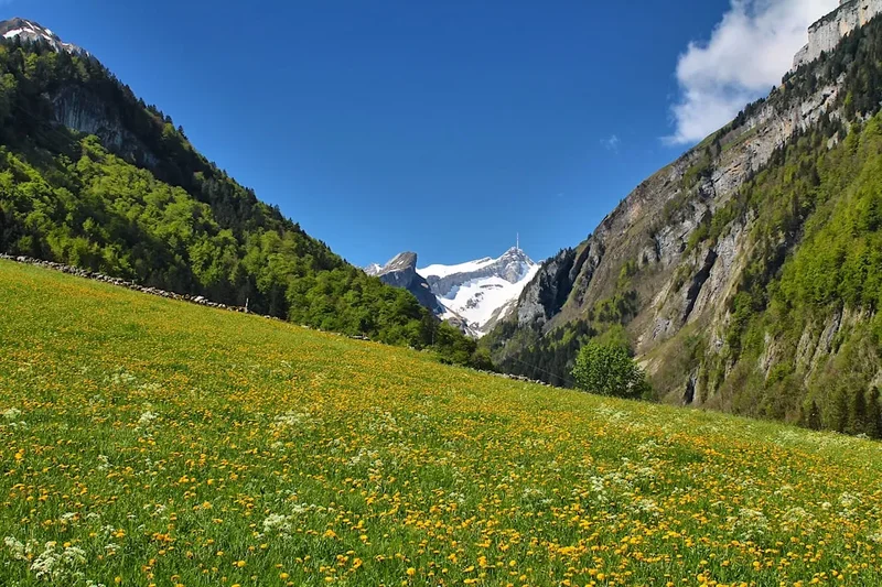
The Albula Pass Trail is a moderate day hike that showcases the breathtaking beauty of the Swiss Alps. Starting from the vicinity of the Albula Pass summit, the trail descends gradually through a landscape of rolling alpine meadows, dotted with wildflowers in the summer months, and framed by imposing mountain peaks. The path is well-maintained, making it accessible to a wide range of hikers, though the elevation gain and descent require a reasonable level of fitness.
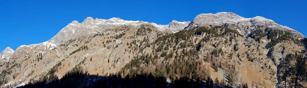
The trail's progression is marked by stunning vistas. As you ascend towards the pass (or descend from it, depending on your chosen direction), panoramic views unfold, revealing the rugged contours of the surrounding mountain ranges. The air is crisp and clean, carrying the scent of pine and alpine flora. Small streams and occasional tarns add to the picturesque scenery, reflecting the dramatic skies above.
While the trail itself is a moderate challenge, the true reward lies in the immersive experience of the alpine environment. The sense of scale is immense, with towering peaks and vast open spaces creating a feeling of profound tranquility. The Albula Pass has historically been an important route, and remnants of its past can be observed along the way, adding a layer of historical context to the natural splendour.
This walk is ideal for those seeking a substantial day hike that offers a genuine taste of the high Alps without the complexities of multi-day expeditions. It’s a chance to connect with nature, breathe in the pure mountain air, and create lasting memories amidst some of Switzerland's most iconic scenery.
History and Cultural Context
The Albula Pass (Albulapass in German) has a long and storied history as a vital transit route through the Swiss Alps. For centuries, it served as a crucial link connecting the Rhine Valley with the Engadin region, facilitating trade and travel long before the advent of modern infrastructure like tunnels and railways.
Evidence suggests that the pass has been used since Roman times, though its significance grew considerably during the medieval period. Merchants, pilgrims, and armies all traversed this challenging route, braving its steep ascents, unpredictable weather, and the isolation of the high alpine environment. The strategic importance of the pass meant it was often a point of contention and control for local rulers.
The development of the Albula Railway, which opened in 1903 and is now a UNESCO World Heritage site, significantly altered the importance of the road pass for long-distance travel. However, the Albula Pass road remains a popular scenic route, particularly during the summer months, and the hiking trails around it offer a chance to experience the landscape in a more traditional, unhurried manner.
The area around the pass is also rich in local folklore and traditions. The hardy nature of the people who have historically lived and worked in these high-altitude regions is reflected in the resilient alpine culture. The trail itself, while not a major historical pilgrimage route in the same vein as some European long-distance paths, follows ancient pathways that have been trodden for generations, connecting communities and landscapes.
Seasonal Highlights and Weather Reality
The Albula Pass Trail is best enjoyed during the warmer months when the snow has receded and the alpine meadows are in bloom. The period from June to October offers the most favourable conditions for hiking.
Spring (May to early June): While the lower sections of the trail may be clear, the higher reaches of the Albula Pass can still be snow-covered. Early June might offer opportunities for experienced hikers with appropriate gear, but caution is advised. Wildflowers begin to emerge, adding splashes of colour to the landscape.
Summer (July to August): This is peak season for the Albula Pass Trail. The weather is generally warmer and more stable, though alpine thunderstorms can develop rapidly in the afternoons. The alpine meadows are at their most vibrant, carpeted with a diverse array of wildflowers. The days are long, providing ample time for hiking and enjoying the scenery. Temperatures typically range from 10°C to 20°C, but can drop significantly at higher elevations or during inclement weather.
Autumn (September to October): Autumn brings a different kind of beauty to the Alps. The foliage begins to change, painting the hillsides in hues of gold, red, and orange. The air becomes crisper, and the skies are often a brilliant blue. While the temperatures start to cool, with daytime highs often between 5°C and 15°C, the clear conditions can offer spectacular views. Snowfall becomes more likely later in October, so it's essential to check weather forecasts before heading out.
Winter (November to April): The Albula Pass road is typically closed to traffic during the winter months due to heavy snowfall and avalanche risk. The hiking trails are covered in deep snow, making them inaccessible for standard hiking. This period is suitable only for experienced winter mountaineers with appropriate equipment and knowledge.
Weather Considerations: Alpine weather is notoriously unpredictable. Even in summer, conditions can change rapidly. Be prepared for sunshine, rain, wind, and even snow, sometimes all within the same day. Always check the local weather forecast before your hike and carry appropriate layers of clothing.
Recommended Itinerary
Albula Pass Trail - Day Hike Itinerary
This itinerary assumes a start from the Albula Pass summit area and a descent towards Thusis. Alternatively, you can start from Thusis and ascend to the pass.
Morning (Approx. 9:00 AM): Arrival at Albula Pass
- Arrive at Albula Pass (Albulapass, Ospizio) via PostBus from Thusis or by car.
- Take a moment to acclimatise and admire the panoramic views from the pass summit.
- Locate the trailhead for the descent towards Thusis.
- Ensure you have all necessary gear, water, and snacks.
Late Morning (Approx. 9:30 AM - 12:30 PM): Descent into Alpine Meadows
- Begin the descent from the pass. The initial section is often well-marked and may involve some rocky terrain.
- The trail gradually opens up into expansive alpine meadows.
- Observe the diverse flora and fauna, and enjoy the sweeping vistas of the surrounding mountain ranges.
- Pass by small streams and potentially some seasonal tarns.
- Distance covered: Approximately 5-6 km.
- Elevation change: Approximately 300-400 m descent.
Midday (Approx. 12:30 PM - 1:30 PM): Lunch Break and Scenic Views
- Find a scenic spot for a packed lunch. Many areas offer flat, comfortable spots with excellent views.
- Rest and rehydrate. This is a good point to assess your progress and energy levels.
- Continue the descent, which may become steeper in sections as you approach the treeline.
Afternoon (Approx. 1:30 PM - 4:00 PM): Through the Forest and Towards the Valley Floor
- The trail will likely transition from open meadows into a mixed forest, predominantly pine and larch.
- The path may become more shaded and the terrain can be uneven with roots and stones.
- Listen to the sounds of the forest and enjoy the cooler air.
- Keep an eye out for signs indicating the proximity to Thusis or the end of the trail.
- Distance covered: Approximately 6-7 km.
- Elevation change: Approximately 250-350 m descent.
Late Afternoon (Approx. 4:00 PM onwards): Arrival and Departure
- Arrive at your designated endpoint near Thusis. This could be a specific bus stop or a parking area.
- If you started from Thusis and ascended, you will reach the Albula Pass summit area.
- Allow time for travel back to your accommodation.
Important Notes:
- This is a one-way hike. Ensure you have arranged transport at your endpoint (e.g., PostBus schedule, pre-booked taxi).
- The trail can be steep and rocky in places; sturdy footwear is essential.
- Carry sufficient water and food, as facilities are limited along the trail.
- Weather can change rapidly; always be prepared for varying conditions.
- Check the PostBus schedule in advance for reliable public transport options.
Planning and Bookings
Book Your Trip
Everything you need to plan your journey
Accommodation
Find places to stay near Thusis
Flights
Search flights to Thusis
Essential Preparation
The Albula Pass Trail is a day hike, which simplifies planning compared to multi-day treks. However, thorough preparation is still crucial for a safe and enjoyable experience. The closest major town and logistical hub is Thusis. From Thusis, you can access the Albula Pass via public transport (PostBus) or by car. If travelling by car, be aware that parking at the pass can be limited, especially during peak season.
Fitness: The trail involves a significant elevation change (650 m gain or loss depending on direction) over a moderate distance. Hikers should be comfortable with sustained uphill or downhill walking for several hours. A good level of cardiovascular fitness and leg strength is recommended. If you are not accustomed to hiking, consider a shorter, less strenuous walk first.
Logistics: Decide whether you will hike from the pass down to Thusis or vice versa. The PostBus service (route 181) is a convenient option for reaching the pass from Thusis. Check the timetable carefully, as services may be infrequent, especially outside of peak season. If driving, ensure your vehicle is in good condition, and be aware of potential road closures due to snow in the shoulder seasons.
Base Town: Thusis is the primary base town. It offers a range of accommodation options, from budget-friendly guesthouses to more comfortable hotels. You will also find supermarkets for purchasing food and supplies, as well as outdoor gear shops for any last-minute necessities. Restaurants and cafés provide opportunities to refuel before or after your hike.
Trail Accommodation
This is a day hike requiring no overnight accommodation.
Required Gear
- Sturdy hiking boots: Waterproof and with good ankle support are essential for navigating uneven terrain. Ensure they are well broken-in to prevent blisters.
- Waterproof and windproof jacket: Alpine weather can change rapidly. A reliable waterproof jacket is crucial for protection against rain and wind.
- Waterproof overtrousers: Highly recommended, especially if rain is forecast.
- Layered clothing: Synthetic or merino wool base layers, a fleece or insulating mid-layer, and an outer shell provide adaptability to changing temperatures. Avoid cotton, which retains moisture.
- Hat and gloves: Even in summer, temperatures at the pass can be cool, and wind can make it feel colder.
- Backpack: A comfortable daypack (20-30 litres) to carry essentials.
- Navigation tools: A map of the area, a compass, and a GPS device or smartphone with offline maps are recommended. While the trail is generally well-marked, it's wise to be prepared.
- First-aid kit: Including blister treatment, pain relievers, antiseptic wipes, bandages, and any personal medications.
- Sun protection: High SPF sunscreen, sunglasses, and a sun hat are important, as the sun's rays are stronger at altitude.
What to Bring
- Food: Pack plenty of high-energy snacks and a substantial lunch. There are no food services along the trail.
- Water: Carry at least 1.5-2 litres of water per person. While there may be streams, it's advisable to treat or filter water if you plan to refill.
- Water treatment: A water filter or purification tablets are recommended if you intend to drink from natural sources.
- Toiletries: Biodegradable soap, toothbrush, toothpaste, hand sanitiser, and toilet paper.
- Trekking poles: Optional but highly recommended, especially for the descent, as they can reduce strain on your knees.
- Camera: To capture the stunning alpine scenery.
- Mobile phone: For emergencies, though reception may be intermittent. Consider a portable power bank.
- Cash: For potential small purchases or bus fares.
Permits
No specific permits are required to hike the Albula Pass Trail. As a public day hike within Switzerland, access is generally free and open to all. However, it is always advisable to check for any local advisories or temporary restrictions that might be in place due to weather conditions or maintenance work.
National Park Regulations: While not a national park in the strictest sense, the Swiss Alps are protected environments. Hikers are expected to adhere to general principles of responsible outdoor recreation, such as staying on marked trails, not disturbing wildlife, and packing out all litter.
Seasonal Access: The primary restriction is seasonal. The Albula Pass road is closed during winter due to snow, making access to the trailhead impossible for most of the year. Ensure you are hiking during the period when the pass is open and the trails are clear of snow.
Other Activities in the Area
The region surrounding Albula Pass and Thusis offers a variety of activities for visitors:
- Albula Railway (UNESCO World Heritage): Experience one of the most spectacular railway lines in the world. The Albula Line, part of the Rhaetian Railway, features impressive viaducts, tunnels, and spiral loops as it traverses the Alps. Day trips from Thusis are highly recommended.
- Hiking in the Engadin Valley: If you have more time, consider exploring the nearby Engadin Valley, famous for its pristine lakes, charming villages like St. Moritz, and extensive network of hiking trails.
- Via Ferrata: For the more adventurous, there are several via ferrata routes in the vicinity, offering thrilling climbs with fixed cables and ladders.
- Mountain Biking: The area boasts numerous mountain biking trails, catering to various skill levels.
- Exploring Thusis: The town of Thusis itself is worth exploring, with its historic centre, local shops, and restaurants. It serves as a convenient gateway to the surrounding natural attractions.
- Lake Marmorera: A picturesque reservoir lake located a short drive from Thusis, offering opportunities for leisurely walks and enjoying the mountain scenery.
Safety and Conditions
Weather: Alpine weather is highly unpredictable. Always check the forecast from a reliable source like MeteoSwiss or MetService before and during your hike. Be prepared for rapid changes, including sudden rain, wind, fog, and even snow, especially at higher elevations. Hypothermia is a risk even in summer if you get wet and cold.
Trail Conditions: The Albula Pass Trail is generally well-maintained, but conditions can vary. In early spring or late autumn, snow and ice may be present, making the trail slippery and potentially hazardous. Rockfall can occur in certain sections, so be aware of your surroundings. Always stay on marked paths to avoid dangerous terrain.
Navigation: While the trail is usually clearly marked, it is essential to carry a map and compass and know how to use them. GPS devices or smartphone apps with offline maps are also valuable tools. Do not rely solely on mobile phone reception, as it can be unreliable in mountainous areas.
Physical Fitness: Ensure you are adequately fit for the demands of the hike. The 650 metres of elevation gain/loss requires a reasonable level of stamina and leg strength. If hiking downhill, trekking poles can significantly reduce stress on your knees.
Water: Carry sufficient water, as there are no facilities along the trail. If you plan to refill from streams, use a water filter or purification tablets.
Emergency: In case of an emergency, call the Swiss emergency number: 144 (ambulance) or 112 (general European emergency number). Inform someone of your hiking plans, including your intended route and expected return time.
Wildlife: While encounters are rare, be aware of local wildlife. Respect their space and do not attempt to feed or approach animals.
Side Trips and Points of Interest
Albula Pass Summit (Albulapass, Ospizio): The starting or ending point of the hike, the pass itself is a point of interest. Historically, it was a vital trade route. Today, it offers stunning panoramic views of the surrounding mountain ranges, including the Piz Kesch massif. There are usually a few small restaurants or huts at the pass offering refreshments and a place to rest.
Alpine Meadows and Flora: Depending on the season, the meadows along the trail are a riot of colour. In summer, expect to see a wide variety of alpine wildflowers, including gentians, edelweiss (though rare), alpine roses, and various species of orchids. The biodiversity of these high-altitude meadows is remarkable.
Tarns and Streams: Small, clear alpine lakes (tarns) and fast-flowing streams are common features along the route. These provide beautiful photographic opportunities and a chance to appreciate the pristine mountain environment. The water is often crystal clear and icy cold.
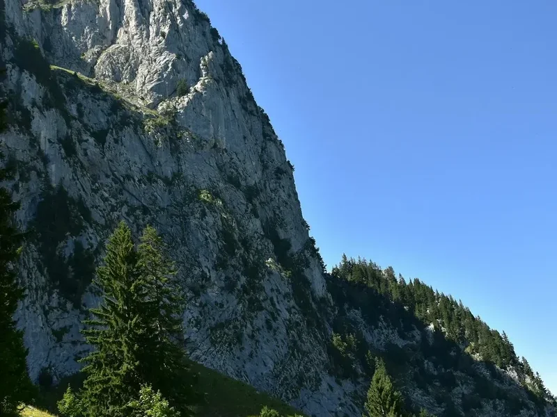
Forest Sections: As the trail descends (or ascends) from the pass, it passes through beautiful alpine forests, typically composed of larch, pine, and fir trees. These sections offer shade and a different atmospheric experience compared to the open alpine terrain.
Views of Piz Kesch: The imposing Piz Kesch (3,418 m) is one of the most prominent peaks visible from the Albula Pass area. Its rugged slopes and glacial features are a constant, impressive backdrop to the hike.
Leave No Trace
The Albula Pass Trail traverses a sensitive alpine environment. Adhering to Leave No Trace principles is essential to preserve its natural beauty and ecological integrity for future visitors.
- Plan Ahead and Prepare: Research the trail, check weather forecasts, and be prepared for all conditions. Know your limits and choose a hike that matches your abilities.
- Travel and Camp on Durable Surfaces: Stick to the marked trail at all times. Avoid cutting switchbacks or walking on fragile vegetation, which can take years to recover.
- Dispose of Waste Properly: Pack out everything you pack in, including all food scraps, wrappers, and any other litter. Use designated toilet facilities where available, or dig a cathole at least 70 metres away from water sources, trails, and campsites if no facilities exist (though this is a day hike, so facilities at the pass are likely).
- Leave What You Find: Do not remove or disturb natural objects such as rocks, plants, or flowers. Take only photographs and memories.
- Minimise Campfire Impacts: Campfires are generally not permitted on day hikes and are highly discouraged in alpine environments due to their impact on vegetation and soil.
- Respect Wildlife: Observe wildlife from a distance. Never feed animals, as it can disrupt their natural behaviours and diets, and can be harmful to their health.
- Be Considerate of Other Visitors: Keep noise levels down, yield to other hikers, and be courteous. Enjoy the peace and quiet of the mountains.
By following these principles, you help ensure that the Albula Pass Trail remains a pristine and enjoyable experience for everyone.