Parang Mountains Trail - Romania's Alpine Majesty
The Parang Mountains Trail is a challenging and rewarding multi-day trek through the heart of Romania's Southern Carpathians. This route offers a spectacular journey across rugged alpine ridges, through ancient forests, and past glacial lakes, showcasing the raw beauty of one of Romania's most significant mountain ranges. Designed for experienced hikers, the trail demands good physical fitness, navigational skills, and preparedness for variable mountain weather. It is a true immersion into a wild and relatively untouched European mountain landscape, offering a profound sense of accomplishment and connection with nature.
- Distance: 50.0 km
- Elevation Gain: 2,500 m
- Duration: 3-4 days
- Difficulty: Challenging
- Best Time: July to September (summer months)
- Closest City: Petroșani
- Trailhead Access: Nearest Airport: Sibiu (SBZ). From Sibiu, take a bus or train to Petroșani. By car: follow E81 to DN66 to Petroșani. Road conditions are generally good. Parking available in Petroșani. Trailhead is accessible from the edge of town. No permits currently required, but check local regulations before hiking. GPS: 45.4000, 23.3667 (approximate trailhead).
- Coordinates: 45.3500, 23.3667
Overview
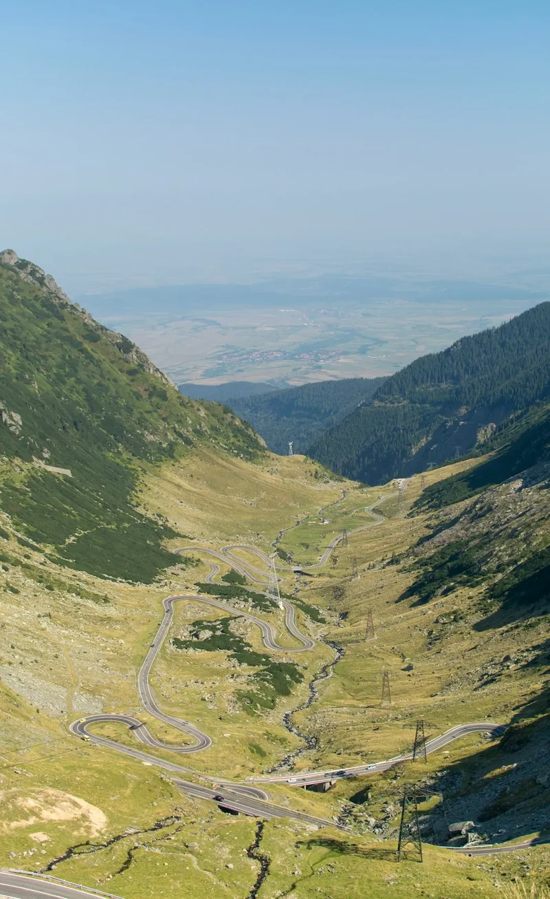
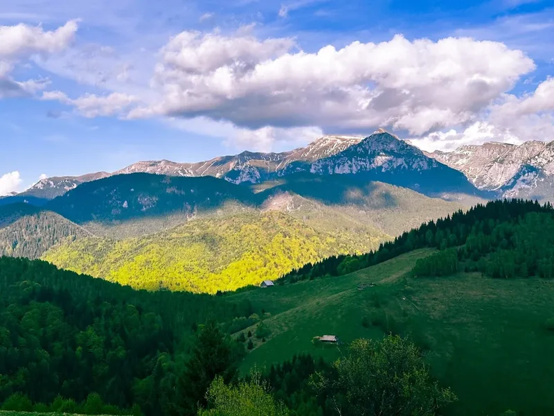
The Parang Mountains Trail is a quintessential Romanian alpine adventure, a route that encapsulates the dramatic beauty and wild character of the Southern Carpathians. This trek is not for the faint-hearted; it traverses high-altitude ridges, demanding significant physical exertion and mental fortitude. The landscape is a breathtaking tapestry of jagged peaks, deep glacial valleys, and expansive plateaus, often dotted with pristine alpine lakes that mirror the surrounding sky.
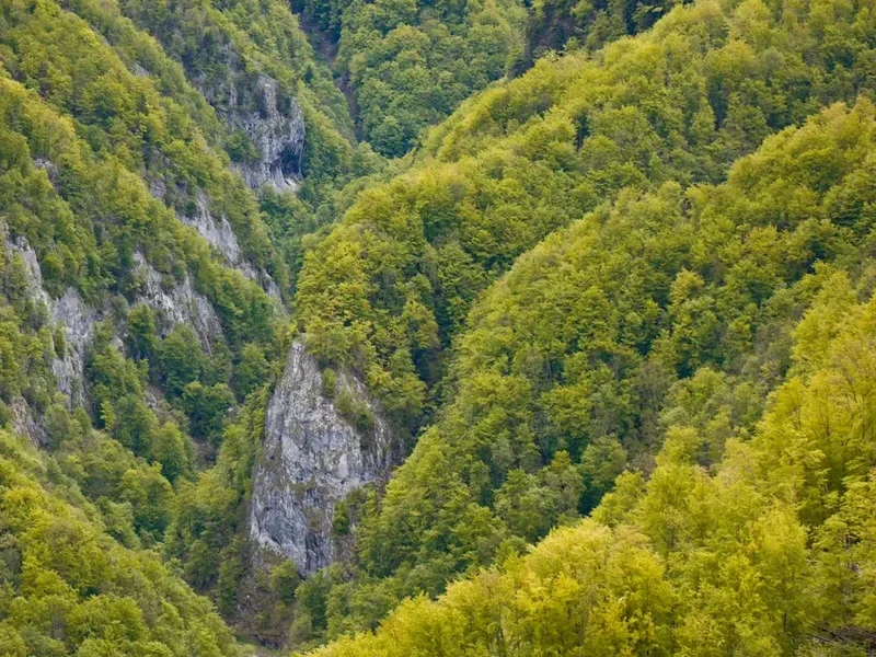
The trail's progression is a testament to the raw power of nature. Hikers will encounter diverse terrain, from dense, ancient coniferous forests that cloak the lower slopes to the stark, rocky expanses of the high alpine zone. The air is crisp and clean, carrying the scent of pine and wild herbs. Wildlife, though often elusive, is present, with opportunities to spot chamois, deer, and a variety of bird species. The silence of the mountains, broken only by the wind or the call of a bird, offers a profound escape from the clamour of modern life.
The Parang Mountains are part of the Retezat-Parang massif, a geological wonderland known for its glacial features. The trail often follows ancient shepherd paths and, in some sections, requires careful navigation across scree slopes and rocky outcrops. The highest points of the trek offer panoramic views that stretch for miles, revealing the vastness of the Romanian wilderness. This is a journey that tests endurance, rewards perseverance, and leaves an indelible mark on the soul of any hiker who undertakes it.
History and Cultural Context
The Parang Mountains have a long and rich history, deeply intertwined with human settlement and pastoralism in Romania. For centuries, these mountains have been a vital grazing ground for shepherds, who have traversed the same trails that modern hikers now follow. The traditional way of life, centred around sheep farming, has shaped the landscape and left behind a legacy of stone shelters, old paths, and a deep connection between the local communities and the mountains.
The region's geological history is equally compelling. The Parang Mountains are a product of intense tectonic activity and extensive glaciation, which carved out the dramatic U-shaped valleys, cirques, and moraines that define the landscape. The numerous glacial lakes, such as the stunning Bucura Lake (though not directly on this specific trail, it is a significant feature of the wider range), are testament to this powerful geological past.
In more recent history, the Parang Mountains have become a significant destination for mountaineering and hiking enthusiasts. The development of marked trails, though sometimes less formalised than in Western European ranges, has opened up this spectacular region to a wider audience. The area is also of ecological importance, hosting a variety of flora and fauna, some of which are unique to the Carpathian ecosystem. The cultural heritage of the region, with its strong rural traditions and connection to the land, adds another layer of depth to the experience of trekking here.
Seasonal Highlights and Weather Reality
The optimal period for hiking the Parang Mountains Trail is during the summer months, from July to September. During this time, the weather is generally more stable, and the snow has typically receded from the higher passes, making the trails accessible and safer.
Summer (July - September): This is the prime hiking season. Days are longer, offering ample daylight for trekking. Temperatures are generally mild, though they can fluctuate significantly at higher altitudes. Alpine meadows burst into bloom, creating a vibrant and colourful landscape. However, mountain weather is notoriously unpredictable. Even in summer, hikers must be prepared for sudden changes, including heavy rain, strong winds, and even occasional snow showers, particularly at higher elevations. Thunderstorms can develop rapidly in the afternoons, posing a significant risk.
Spring (April - June): While tempting, spring is generally not recommended for this challenging trail. Snowmelt can make many sections treacherous and impassable, especially at higher altitudes. Rivers and streams can be swollen and dangerous to cross. The higher passes may remain snow-covered well into June.
Autumn (October - November): Autumn can offer crisp, clear days and stunning autumnal colours in the forests. However, temperatures begin to drop significantly, and the risk of early snow increases, especially in late October and November. Days become shorter, and the weather can become much more severe, with a higher chance of storms.
Winter (December - March): The Parang Mountains are a winter wonderland, but this trail is strictly for experienced winter mountaineers with appropriate gear and skills. Snowfall can be heavy, and avalanche risk is high. The trails are often completely obscured, and navigation becomes extremely difficult.
Weather Considerations: Regardless of the season, always check the weather forecast before and during your hike. Be prepared for all conditions, including cold temperatures, rain, and wind, even if the forecast appears favourable. Layering clothing is essential.
Recommended Itinerary
3-Day Parang Mountains Trail Itinerary
Day 1: Petroșani to Cabana Obârșia Lotrului
- Distance: Approximately 15 km
- Elevation gain: Approximately 1,000 m
- Time: 6–8 hours
- Start from Petroșani, following marked trails into the forested lower slopes of the Parang Mountains.
- The initial part of the hike involves a steady ascent through dense forests, gradually opening up to more expansive views.
- Pass through areas that may have been historically used for pastoralism.
- The trail can be steep and demanding, requiring good stamina.
- Arrive at Cabana Obârșia Lotrului, a mountain refuge offering basic accommodation and facilities.
- This day focuses on gaining significant elevation and transitioning from the valley to the mountain environment.
Day 2: Cabana Obârșia Lotrului to Refugiul Ștefan Rusu (or similar high camp)
- Distance: Approximately 20 km
- Elevation gain: Approximately 1,200 m
- Time: 8–10 hours
- This is the most challenging day, traversing the high alpine ridges of the Parang Mountains.
- The route follows the main ridge, offering spectacular panoramic views of the surrounding peaks and valleys.
- Expect rocky terrain, scree slopes, and potentially exposed sections.
- Navigation is crucial, as trails can be less distinct in the high alpine zone.
- Pass by several glacial lakes, depending on the exact route taken.
- Aim to reach Refugiul Ștefan Rusu or another suitable high-altitude camping spot/refuge.
- This day is about endurance, enjoying the vast alpine scenery, and experiencing the true wilderness of the Parang range.
Day 3: Refugiul Ștefan Rusu to Petroșani (via alternative route or descent)
- Distance: Approximately 15 km
- Elevation loss: Approximately 1,300 m
- Time: 5–7 hours
- Descend from the high ridges, potentially via a different route to Petroșani.
- The descent can be steep and may involve navigating through forests and open slopes.
- Enjoy final views of the Parang Mountains as you make your way back towards civilisation.
- The exact route will depend on trail markings and your chosen descent path.
- Arrive back in Petroșani, completing the challenging Parang Mountains Trail.
- This day focuses on a steady descent and returning to the trailhead.
Alternative 4-Day Itinerary:
- Day 1: Petroșani to Cabana Obârșia Lotrului (as above)
- Day 2: Cabana Obârșia Lotrului to a high camp/refuge near a prominent lake (e.g., Lacul Câlcescu area if accessible)
- Day 3: Explore the high alpine area, potentially summiting a peak, and descend to a lower refuge or campsite.
- Day 4: Descend to Petroșani.
Important Notes:
- This itinerary is a guideline; actual distances and times may vary based on specific route choices, trail conditions, and individual fitness.
- Accommodation in mountain refuges (cabanas) is basic and often requires booking in advance, especially during peak season. Some sections may involve wild camping (check local regulations).
- Water sources can be plentiful from streams and lakes, but purification is always recommended.
- Weather can change rapidly; always be prepared for cold, rain, and wind.
- Navigation skills and a reliable map and compass are essential. GPS devices or apps are highly recommended.
Planning and Bookings
Book Your Trip
Everything you need to plan your journey
Accommodation
Find places to stay near Petroșani
Flights
Search flights to Petroșani
Essential Preparation
The Parang Mountains Trail is a demanding trek that requires thorough preparation. Before embarking on this journey, it is crucial to assess your physical fitness. This trail involves significant elevation gain and loss, often over rugged and uneven terrain, for multiple consecutive days. A good level of cardiovascular fitness and leg strength is essential. Training hikes that simulate the conditions, including carrying a loaded backpack, are highly recommended.
Logistics for reaching the trailhead in Petroșani are relatively straightforward. Sibiu is the nearest major airport, with onward connections by bus or train to Petroșani. If driving, the E81 and DN66 roads are generally well-maintained. Parking is available in Petroșani. It is advisable to spend at least one night in Petroșani before starting the trek to finalise preparations and acclimatise.
Communication can be limited in the mountains. Inform someone of your planned route and expected return date. Consider carrying a personal locator beacon (PLB) or satellite messenger for emergencies, especially if hiking solo or in remote sections.
Trail Accommodation
Accommodation along the Parang Mountains Trail is primarily in mountain refuges (cabanas) or through wild camping. These facilities are generally basic, reflecting the remote nature of the region.
Cabanas (Mountain Refuges):
- Cabana Obârșia Lotrului: This is a well-known refuge and often serves as a starting or stopping point. Facilities typically include dormitory-style sleeping areas, a communal dining space, and sometimes basic catering. It is advisable to book in advance, especially during the summer months.
- Other Refuges/Shelters: Depending on the specific route chosen, there may be other smaller refuges or shelters along the trail. These are often more rudimentary, providing basic shelter from the elements.
Wild Camping:
- Wild camping is generally permitted in Romania, provided you follow Leave No Trace principles and respect the environment. It is advisable to camp away from marked trails and water sources, and to pack out all rubbish. Always check local regulations or ask at the nearest ranger station if unsure.
- Designated camping spots may be available near some cabanas.
What's Provided: Basic shelter, sleeping platforms or bunks (bring your own sleeping bag), and sometimes access to water. Some cabanas may offer simple meals or drinks. Toilets are usually basic pit latrines or composting toilets.
What's NOT Provided: Bedding (sheets, blankets), cooking equipment, food, electricity, running hot water, or mobile phone signal.
Seasonal Availability: Cabanas are generally open during the summer hiking season (July-September). Outside of this period, some may be closed or operate with limited services. Wild camping is possible year-round, but conditions can be extreme in winter.
Costs: Costs for cabanas vary but are generally affordable. Expect to pay a modest fee per night for a bunk. Wild camping is free.
Required Gear
- Sturdy Hiking Boots: Waterproof, with good ankle support and a well-worn sole. Essential for navigating rocky and uneven terrain.
- Waterproof and Windproof Jacket: A breathable, high-quality jacket (e.g., Gore-Tex) is crucial for protection against sudden weather changes.
- Waterproof Overtrousers: To complement the jacket, ensuring full protection from rain and wind.
- Warm Layers: Including a fleece jacket or insulated jacket, and thermal base layers (merino wool or synthetic).
- Hat and Gloves: Even in summer, temperatures at altitude can be cold.
- Backpack: A comfortable, well-fitting backpack of 50-65 litres capacity, with a rain cover.
- Navigation Tools: A detailed topographic map of the Parang Mountains, a compass, and a GPS device or smartphone with offline maps and navigation app. Knowledge of how to use them is vital.
- Head Torch: With spare batteries, for early starts, late finishes, or use in refuges.
- First-Aid Kit: Comprehensive kit including blister treatment, pain relievers, antiseptic wipes, bandages, and any personal medications.
- Sun Protection: High SPF sunscreen, sunglasses, and a wide-brimmed hat. The sun can be intense at altitude.
- Trekking Poles: Highly recommended for stability on ascents and descents, and to reduce strain on knees.
What to Bring
- Food: Sufficient non-perishable food for the duration of the trek, including high-energy snacks, meals for breakfast, lunch, and dinner. Consider lightweight, calorie-dense options.
- Water Treatment: A water filter or purification tablets are essential, as stream and lake water, while plentiful, should be treated.
- Cooking Equipment: A lightweight camping stove, fuel, a pot, utensils, and a lighter or waterproof matches.
- Sleeping Bag: A warm sleeping bag rated for cool mountain temperatures (e.g., comfort rating 0-5°C).
- Toiletries: Biodegradable soap, toothbrush, toothpaste, toilet paper, hand sanitiser.
- Personal Items: Camera, power bank for electronics, book or journal for downtime.
- Emergency Shelter: A lightweight emergency bivvy bag or space blanket.
- Cash: For use at mountain refuges, as card payment facilities are unlikely to be available.
- Rubbish Bags: To pack out all waste.
Permits
Currently, no specific permits are required to hike the Parang Mountains Trail. Romania's national parks and mountain areas are generally accessible to the public without the need for advance booking or permit purchase for standard hiking activities. However, it is always advisable to check with local authorities or the Romanian Mountain Rescue Service (Salvamont) for any last-minute changes in regulations or specific area restrictions, especially concerning wild camping or access to certain protected zones.
While permits are not mandatory, it is highly recommended to register your hiking plans with the local Salvamont unit responsible for the Parang Mountains region. This is a voluntary measure but can be invaluable in case of an emergency, as it informs rescue services of your intended route and expected return time.
Key Considerations:
- No Booking System: Unlike some highly regulated trails in other countries, the Parang Mountains Trail does not operate on a booking system for daily walker numbers.
- Respect for Nature: While no permits are needed, adherence to Leave No Trace principles and respect for the natural environment is paramount.
- Local Regulations: Always be aware of and comply with any local rules regarding camping, fires, or protected areas. Information can often be found at park entrances or from local tourism offices.
- Salvamont Registration: Consider registering your trip with Salvamont. This service is dedicated to mountain rescue and safety.
Other Activities in the Area
While the Parang Mountains Trail is the primary draw, the surrounding region offers several other activities for those looking to extend their stay or explore further:
- Exploring Petroșani: The closest city, Petroșani, has a mining history and offers a glimpse into local Romanian life. You can find accommodation, restaurants, and essential supplies here.
- Visiting nearby national parks: The Parang Mountains are part of a larger network of protected areas in the Southern Carpathians. The Retezat National Park, known for its numerous glacial lakes and diverse wildlife, is a significant neighbouring park that could be explored before or after your trek.
- Cultural tourism: Explore traditional Romanian villages in the surrounding valleys to experience local culture, cuisine, and hospitality.
- Adventure sports: Depending on the season and specific locations, activities like rock climbing or mountain biking might be available in the wider region, though specific trails for these are less developed than hiking routes.
- Relaxation: After a challenging trek, enjoy the local cuisine and relax in Petroșani or a nearby rural guesthouse.
Safety and Conditions
Pre-Departure Checks:
- Weather Forecast: Always check the most up-to-date mountain weather forecast for the Parang Mountains region from reliable sources like ANM (National Meteorological Administration of Romania) or specialised mountain weather services. Be prepared for rapid changes.
- Trail Conditions: While official trail condition reports are less common than in some other countries, consult local resources or the Salvamont (Romanian Mountain Rescue) for any known hazards or closures.
- Route Planning: Ensure you have a detailed map and understand your chosen route. Familiarise yourself with potential escape routes or alternative paths in case of emergency.
Mountain Hazards:
- Altitude: While not extremely high, the Parang Mountains can reach altitudes where altitude sickness can be a concern for some individuals. Ascend gradually and stay hydrated.
- Terrain: The trail involves steep ascents and descents, rocky sections, scree slopes, and potentially exposed ridges. Proper footwear and trekking poles are essential.
- Weather: Mountain weather can change drastically and without warning. Be prepared for cold temperatures, strong winds, heavy rain, fog, and even snow, especially at higher elevations, even in summer. Hypothermia is a real risk.
- Navigation: Trails can be poorly marked in places, especially in the high alpine zones. A good map, compass, and GPS device are critical. Do not rely solely on mobile phone apps, as signal can be unreliable.
- Water Crossings: Streams and rivers can become swollen and dangerous, particularly after heavy rain or during snowmelt. Assess crossings carefully before attempting.
- Wildlife: While encounters are rare, be aware of local wildlife. Store food properly to avoid attracting animals.
Emergency Procedures:
- Salvamont: The Romanian Mountain Rescue Service (Salvamont) is the primary emergency response team. Know their contact numbers (often 0-SALVAMONT or 112 in Romania).
- Personal Locator Beacon (PLB): Consider carrying a PLB or satellite messenger for reliable communication in areas with no mobile signal.
- Inform Others: Always leave your detailed itinerary and expected return time with a trusted contact.
General Safety Advice: Hike with a partner if possible. Carry sufficient food and water. Pace yourself and take regular breaks. Be aware of your physical limits and do not take unnecessary risks.
Side Trips and Points of Interest
While the main Parang Mountains Trail offers a comprehensive alpine experience, several points of interest and potential side trips can enhance your journey:
Glacial Lakes: The Parang Mountains are renowned for their numerous glacial lakes. While the main trail may pass by some, dedicated side trips can lead to more secluded and spectacular bodies of water. Lacul Câlcescu, though a significant detour, is one of the largest and most beautiful glacial lakes in the range, offering stunning reflections of the surrounding peaks. Exploring these lakes provides opportunities for photography and quiet contemplation of the alpine environment.
Peak Summits: The trail often traverses high ridges, but dedicated ascents to prominent peaks can offer even more expansive views. Peaks like Vârful Parângul Mare (2,519 m), the highest in the range, or Vârful Cârja, offer challenging but rewarding climbs. These ascents typically require good navigation skills and may add significant time to your day.
Shepherd Huts and Traditional Life: In some areas, you may encounter traditional shepherd huts (stâne) and witness aspects of pastoral life that have persisted for centuries. While these are working areas, observing this traditional way of life can be a unique cultural experience. Always approach with respect and ask permission before taking photographs.
Ancient Forests: The lower slopes of the Parang Mountains are covered in ancient coniferous forests, including spruce and fir. Hiking through these primeval woodlands offers a sense of timelessness and a chance to appreciate the rich biodiversity of the Carpathian ecosystem. Look for unique flora and listen to the sounds of the forest.
Geological Formations: The mountains are a testament to powerful geological forces. Keep an eye out for interesting rock formations, moraines left by ancient glaciers, and the distinct shapes of cirques carved into the mountainsides.
Leave No Trace
The Parang Mountains are a pristine natural environment, and it is crucial for all hikers to practice Leave No Trace principles to preserve their beauty and ecological integrity for future generations. These principles are not just guidelines; they are essential for responsible outdoor recreation.
Your responsibility as a hiker:
- Plan Ahead and Prepare: Understand the trail, weather conditions, and any local regulations. Pack appropriately and know your limits.
- Travel and Camp on Durable Surfaces: Stick to marked trails whenever possible. If wild camping, choose established sites or durable surfaces like rock, gravel, or dry grass, away from water sources and vegetation. Avoid creating new campsites.
- Dispose of Waste Properly: Pack out everything you pack in, including all food scraps, wrappers, and toilet paper. Use designated toilets where available, or dig catholes 60-70 metres away from water, trails, and campsites.
- Leave What You Find: Do not remove or disturb natural objects such as rocks, plants, or historical artefacts. Take only photographs and memories.
- Minimise Campfire Impacts: Campfires are generally discouraged in the mountains due to their impact on vegetation and soil. If permitted and necessary, use established fire rings and keep fires small. Ensure fires are completely extinguished before leaving.
- Respect Wildlife: Observe wildlife from a distance. Never feed animals, as this can disrupt their natural behaviours and diets. Store food securely to prevent attracting animals.
- Be Considerate of Other Visitors: Keep noise levels down, yield to others on the trail, and respect the solitude of the wilderness.
By adhering to these principles, you help ensure that the Parang Mountains remain a wild and beautiful place for everyone to enjoy.