
Pico das Agulhas Negras Trail
The Pico das Agulhas Negras Trail, located within the Parque Nacional do Itatiaia in Brazil, is a challenging and rewarding mountain trek leading to the summit of Pico das Agulhas Negras, one of the highest peaks in the Mantiqueira Mountains. This trail is renowned for its dramatic granite formations, breathtaking panoramic views, and the unique alpine-like environment found at higher elevations in this tropical region. It's a journey that tests physical endurance and offers a profound connection with a rugged, ancient landscape.
- Distance: 9.0 km one-way
- Elevation Gain: 1200 m
- Duration: 8-10 hours
- Difficulty: Challenging
- Best Time: May to September (dry season)
- Closest City: Resende
- Trailhead Access: Nearest airport: Rio de Janeiro (GIG). From Rio, take a bus to Resende. From Resende, hire a taxi/transfer to the Parque Nacional do Itatiaia entrance (Portaria do Parque Nacional do Itatiaia). Then follow the road to Posto Marcão (near Abrigo Rebouças). Road is paved but can be narrow. Parking available at Posto Marcão. Park entrance fee/registration might be required.
- Coordinates: -22.3888, -44.6611
Overview
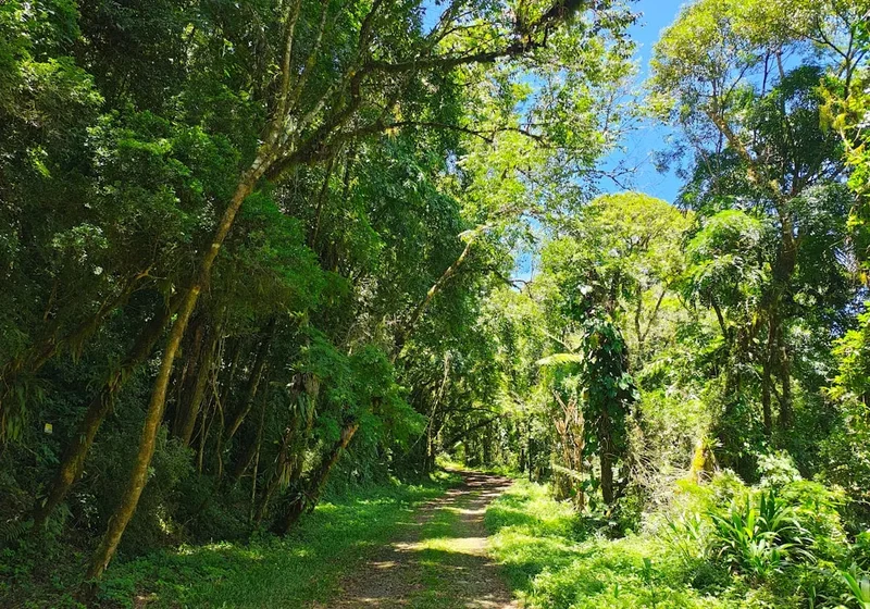
The Pico das Agulhas Negras Trail is a demanding ascent that takes hikers from the lower montane forests of the Itatiaia National Park to the exposed, rocky summit of Pico das Agulhas Negras, meaning "Black Needles Peak." The trail is characterised by its steep gradient and the transition through distinct ecological zones. Initially, the path winds through lush Atlantic Forest, rich with diverse flora and fauna. As elevation increases, the vegetation becomes more sparse, giving way to rocky outcrops and alpine-like meadows, a stark contrast to the typical tropical environment of Brazil.
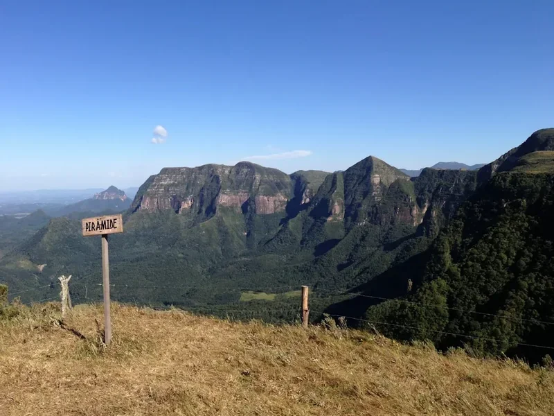
The final approach to the summit involves scrambling over large granite boulders and navigating narrow ledges, requiring a good head for heights and a degree of agility. The peak itself is a cluster of sharp, dark granite spires, hence its name. Reaching the summit rewards hikers with unparalleled 360-degree views of the surrounding Mantiqueira Mountains, vast expanses of the Brazilian plateau, and on clear days, distant horizons stretching for kilometres. The park's high altitude creates a cooler microclimate, often experiencing fog and mist that can add an ethereal, dramatic quality to the landscape, but also significantly reduce visibility and increase the challenge.
This trail is not for the faint-hearted. It demands significant physical fitness due to the substantial elevation gain over a relatively short distance. The technical sections near the summit require careful footing and concentration. However, for those prepared to meet the challenge, the Pico das Agulhas Negras Trail offers an unforgettable adventure, showcasing the unique geological and ecological diversity of Brazil's highlands.
History and Cultural Context
The Parque Nacional do Itatiaia, established in 1937, is Brazil's oldest national park. Its creation was driven by the desire to protect the unique ecosystems of the Mantiqueira Mountains, a significant mountain range that forms part of the border between the states of Rio de Janeiro, Minas Gerais, and São Paulo. The park's high-altitude plateau, known as the "Planalto do Itatiaia," is a geological marvel, characterised by ancient granite formations sculpted by millennia of erosion.
Pico das Agulhas Negras, with its distinctive spires, has long been a landmark for indigenous peoples and early settlers. The region's higher elevations provided a cooler climate and different resources compared to the surrounding lowlands, making it a place of interest for exploration and, in more recent times, for mountaineering and hiking. The development of trails within the park, including the route to Agulhas Negras, was part of the broader effort to make these natural wonders accessible for scientific study and public appreciation.
The park's establishment was a crucial step in Brazil's conservation history, recognising the importance of preserving these unique montane environments. Over the decades, the park has become a vital centre for research into high-altitude flora and fauna, many of which are endemic to the region. The trails, including the one to Agulhas Negras, are maintained to allow visitors to experience this remarkable landscape while minimising human impact, preserving its natural beauty and ecological integrity for future generations.
Seasonal Highlights and Weather Reality
The best time to hike the Pico das Agulhas Negras Trail is during the dry season, which typically runs from May to September. During these months, rainfall is significantly lower, leading to clearer skies and more stable weather conditions. This period offers the highest probability of enjoying unobstructed views from the summit and navigating the rocky sections with greater safety.
Dry Season (May to September): This is the prime hiking period. Days are generally sunny and cool, with temperatures often ranging from 10°C to 20°C during the day, dropping significantly at night. The lower humidity and reduced chance of rain make the ascent more comfortable and the summit views more reliable. However, even in the dry season, weather can change rapidly at higher altitudes. Fog and strong winds can appear unexpectedly, so preparedness is always essential.
Wet Season (October to April): This period is characterised by frequent, heavy rainfall, often in the form of afternoon thunderstorms. While the landscape is lush and green, the trails can become muddy and slippery, increasing the risk of falls. Visibility from the summit is often poor due to persistent cloud cover and fog. Thunderstorms pose a significant danger, especially on exposed ridges and the summit itself. Hiking during this season is generally not recommended for those seeking clear views or a safer experience, and requires extreme caution and appropriate gear.
Temperature Fluctuations: Regardless of the season, temperatures at higher elevations can be considerably cooler than in the surrounding lowlands. Even during the dry season, mornings and evenings can be quite chilly, and the summit can feel significantly colder due to wind chill. Layering clothing is crucial for managing temperature changes throughout the day.
Recommended Itinerary
Pico das Agulhas Negras Trail - Day Hike Itinerary
Early Morning (Approx. 6:00 AM - 7:00 AM): Departure from Base Town
- Depart from Resende or your accommodation near the park entrance.
- Travel to the Parque Nacional do Itatiaia entrance (Portaria do Parque Nacional do Itatiaia).
- Continue by vehicle along the park road towards Posto Marcão (near Abrigo Rebouças). This road is paved but can be narrow and winding.
- Park your vehicle at Posto Marcão. Ensure you have completed any necessary park registration or paid entrance fees.
Morning (Approx. 7:00 AM - 8:00 AM): Trailhead and Initial Ascent
- Begin the hike from the vicinity of Posto Marcão. The trailhead is generally well-marked.
- The initial section of the trail ascends through the Atlantic Forest.
- Enjoy the cooler morning air and the sounds of the forest.
- Distance covered: Approximately 2-3 km.
- Elevation gain: Gradual to moderate.
Late Morning (Approx. 10:00 AM - 12:00 PM): Transition to Rocky Terrain
- The trail begins to steepen considerably.
- Vegetation starts to change, with trees becoming more stunted and rocky outcrops becoming more frequent.
- You will start to encounter larger boulders and more exposed sections.
- Distance covered: Approximately 3-4 km from the start.
- Elevation gain: Significant, becoming steeper.
Midday (Approx. 12:00 PM - 2:00 PM): Summit Approach and Scrambling
- The final approach to Pico das Agulhas Negras.
- This section involves significant scrambling over large granite boulders, navigating narrow paths, and potentially using hands for balance.
- The terrain becomes more technical and requires careful footing and a good sense of direction.
- The summit spires become visible, offering a dramatic visual reward.
- Distance covered: Approximately 4-4.5 km from the start.
- Elevation gain: Steepest section, with substantial vertical gain.
Afternoon (Approx. 2:00 PM - 3:00 PM): Summit and Views
- Reach the summit of Pico das Agulhas Negras.
- Spend time enjoying the panoramic views (weather permitting).
- Take photographs and rest.
- Note: Summit conditions can change rapidly; be prepared for wind, fog, or rain.
Late Afternoon (Approx. 3:00 PM - 6:00 PM): Descent and Return to Trailhead
- Begin the descent. The descent can be as challenging as the ascent, especially on the rocky sections.
- Exercise caution to avoid slips and falls.
- Retrace your steps back through the different ecological zones.
- Distance covered: Approximately 4.5 km back to the trailhead.
- Elevation loss: Significant.
Evening (Approx. 6:00 PM onwards): Return to Base
- Arrive back at Posto Marcão.
- Drive back to Resende or your accommodation.
- Celebrate your accomplishment!
Important Notes:
- This is a challenging day hike requiring excellent physical fitness.
- Start early to allow ample time and avoid afternoon thunderstorms.
- Carry sufficient water and high-energy snacks.
- The summit can be very cold and windy; pack warm layers and waterproofs.
- Be prepared for technical scrambling near the summit.
- Check weather forecasts before and during your hike.
Planning and Bookings
Book Your Trip
Everything you need to plan your journey
Accommodation
Find places to stay near Resende
Flights
Search flights to Resende
Essential Preparation
The Pico das Agulhas Negras Trail is located within the Parque Nacional do Itatiaia, Brazil's oldest national park. Planning your trip well in advance is crucial for a safe and enjoyable experience. The closest major city with good transport links is Resende, which serves as a convenient base town. From Resende, you will need to arrange transport to the park entrance and then further into the park to the trailhead at Posto Marcão.
Logistics:
- Transport: The nearest major airport is Rio de Janeiro (GIG). From Rio, you can take a bus to Resende (approximately 3-4 hours). In Resende, you can hire a taxi or arrange a private transfer to the park. The road within the park to Posto Marcão is paved but can be narrow and winding, so a reliable vehicle or experienced driver is recommended.
- Park Entrance: You will likely need to pay an entrance fee for the Parque Nacional do Itatiaia. It is advisable to check the park's official website or contact park authorities for the most up-to-date information on fees, opening hours, and any required registration procedures.
- Accommodation: Resende offers a range of accommodation options, from budget hostels to mid-range hotels. Staying in Resende the night before and after your hike is recommended to allow for early starts and to recover.
- Fitness: This trail is demanding, with a significant elevation gain of 1200 metres over 9 km. A high level of cardiovascular fitness and leg strength is essential. Regular hiking, running, or strength training in the weeks leading up to your trip is highly recommended.
Trail Accommodation
This is a day hike requiring no overnight accommodation.
Required Gear
- Sturdy hiking boots: Waterproof and with good ankle support are essential for navigating the varied and often uneven terrain, especially the rocky sections near the summit.
- Waterproof and windproof jacket: Weather can change rapidly at high altitudes. A reliable waterproof and windproof outer layer is crucial for protection against rain, wind, and cold.
- Warm layers: Even in the dry season, temperatures can drop significantly, especially at the summit. Bring thermal base layers, a fleece or insulated mid-layer, and a warm hat and gloves.
- Durable hiking trousers: Quick-drying and comfortable trousers are recommended.
- Backpack: A comfortable daypack (25-35 litres) to carry essentials, including water, food, extra clothing, and safety equipment.
- Navigation tools: A reliable map of the park and trail, a compass, and a GPS device or smartphone with offline maps downloaded. Mobile signal can be unreliable.
- Head torch: With spare batteries, in case of an early start or a delayed descent.
- First-aid kit: Comprehensive kit including blister treatment, pain relievers, antiseptic wipes, bandages, and any personal medications.
- Sun protection: High SPF sunscreen, sunglasses, and a wide-brimmed hat. The sun can be intense at higher altitudes, even on cloudy days.
What to Bring
- Water: Carry at least 2-3 litres of water per person. There are no reliable water sources on the upper parts of the trail, and any water found should be treated.
- Water treatment: Water filter or purification tablets as a backup or for treating water if necessary.
- Food: High-energy snacks and a packed lunch. Examples include energy bars, nuts, dried fruit, sandwiches, and fruit.
- Toiletries: Biodegradable soap, toothbrush, toothpaste, and hand sanitiser.
- Toilet paper: Pack out all used toilet paper.
- Emergency shelter: A lightweight emergency blanket or bivvy bag can be a lifesaver in unexpected situations.
- Trekking poles: Optional, but can be very helpful for stability and reducing strain on knees during the ascent and descent.
- Camera: To capture the stunning scenery.
- Identification: Carry your identification documents.
Permits
Access to the Parque Nacional do Itatiaia and its trails, including the Pico das Agulhas Negras Trail, typically requires an entrance fee. It is essential to verify the current permit requirements and fees directly with the park authorities or through their official website before your visit. Information regarding park opening hours, specific trail access rules, and any necessary registration for hikers should also be confirmed.
Park Entrance Fees:
- Fees are usually charged per person and can vary based on nationality (e.g., different rates for Brazilians and international visitors).
- It is advisable to check the official website of ICMBio (Instituto Chico Mendes de Conservação da Biodiversidade), the Brazilian federal agency responsible for national parks, for the most accurate and up-to-date fee structure.
Trail Access and Registration:
- While specific permits for individual trails like Agulhas Negras might not always be required, registration at the park entrance or at designated points within the park (such as Posto Marcão) is often mandatory. This helps park rangers monitor visitor numbers and track hikers for safety purposes.
- Ensure you understand the park's regulations regarding camping (if applicable for longer stays, though not for this day hike), waste disposal, and interaction with wildlife.
Booking Strategy:
- For a day hike like Pico das Agulhas Negras, advance booking of permits is generally not required unless the park has specific visitor limits or special event restrictions. However, it is always prudent to check the park's official channels for any such requirements.
- If you plan to visit during peak holiday periods or weekends, arriving early in the day is recommended to secure parking and avoid potential queues at the entrance.
Important Considerations:
- Always carry your identification and proof of any permits or fees paid.
- Familiarise yourself with the park's emergency contact numbers.
Other Activities in the Area
The Parque Nacional do Itatiaia and its surroundings offer a variety of activities for nature enthusiasts and adventurers:
- Hiking to Prateleiras: Another iconic rock formation within the park, Prateleiras (meaning "shelves" or "plateaus") offers a different, though equally challenging, hiking experience with unique geological features and stunning views.
- Exploring the Itatiaia Plateau: Beyond the main peaks, the high-altitude plateau offers a unique landscape with diverse flora and fauna. Shorter, less strenuous walks can be undertaken to appreciate the alpine-like environment.
- Birdwatching: The park is a haven for a wide variety of bird species, including many endemic to the Atlantic Forest and high-altitude ecosystems. Keep an eye out for toucans, hummingbirds, and various tanagers.
- Visiting the National Park Museum: Located within the park, the museum provides valuable insights into the history, geology, flora, and fauna of Itatiaia.
- Photography: The dramatic landscapes, unique rock formations, and diverse wildlife provide ample opportunities for photographers. Sunrise and sunset can offer particularly spectacular light.
- Relaxation in Resende: After a strenuous hike, enjoy the amenities of Resende. Explore the town, sample local cuisine, or simply relax and recover.
- Visiting nearby waterfalls: Depending on the season and accessibility, there may be other waterfalls in the vicinity of the park that are worth exploring.
Safety and Conditions
Pre-Hike Checks:
- Weather Forecast: Always check the weather forecast for the Parque Nacional do Itatiaia and specifically for high-altitude areas before you set out. MetSul or other reliable Brazilian weather services can provide detailed forecasts. Be aware that conditions can change rapidly.
- Park Alerts: Check the official website of ICMBio or contact the park administration for any alerts, trail closures, or specific safety advisories.
- Road Conditions: While the road to Posto Marcão is paved, it can be narrow and winding. Ensure your vehicle is in good condition, and drive cautiously.
Trail Hazards:
- Steep Terrain and Scrambling: The trail is steep throughout, and the final section to the summit involves significant scrambling over large, uneven rocks. This requires good balance, agility, and a head for heights. Falls can occur, especially on the descent.
- Weather Changes: High altitudes are prone to sudden weather shifts. Fog can roll in quickly, drastically reducing visibility and making navigation difficult. Hypothermia is a risk even in warmer months if you get wet and cold.
- Thunderstorms: Afternoon thunderstorms are common, particularly during the wet season. If you hear thunder or see lightning, descend immediately to a lower, safer elevation. Avoid exposed ridges and the summit during storms.
- Slippery Surfaces: Rocks and paths can become slippery, especially after rain or in foggy conditions. Wear appropriate footwear with good grip.
- Wildlife: While large dangerous animals are not a primary concern on this trail, be aware of your surroundings. Respect any wildlife you encounter and do not feed them.
Personal Safety Measures:
- Hike with a Buddy: It is always safer to hike with at least one other person.
- Inform Someone: Let a friend or family member know your hiking plans, including your intended route, start time, and expected return time.
- Carry a Mobile Phone: Ensure your phone is fully charged. However, be aware that mobile signal is often unreliable within the park. Consider carrying a portable power bank.
- Emergency Contacts: Have the park's emergency contact numbers readily available.
- Pace Yourself: Do not rush. Take breaks as needed and listen to your body.
- Stay Hydrated and Nourished: Drink water regularly and eat snacks to maintain energy levels.
Travel insurance is strongly recommended to cover potential medical emergencies, evacuation, and trip cancellations.
Side Trips and Points of Interest
The Summit Spires: The most prominent feature of the trail is the cluster of sharp, dark granite spires that give Pico das Agulhas Negras its name. These formations are a result of millions of years of erosion and offer a dramatic and unique geological spectacle. The final approach involves navigating around and between these impressive rock structures.
Panoramic Views: On a clear day, the summit of Pico das Agulhas Negras provides breathtaking 360-degree views. You can see the vast expanse of the Mantiqueira Mountains stretching out in all directions, the rolling hills of the Brazilian plateau, and potentially distant cities or towns. The contrast between the rugged, rocky summit and the green lowlands below is striking.
Ecological Transition Zones: The trail offers a fascinating journey through distinct ecological zones. You begin in the dense, humid Atlantic Forest, characterised by tall trees, ferns, and a rich understory. As you ascend, the vegetation gradually changes to stunted trees, shrubs, and eventually to rocky, alpine-like meadows with hardy grasses and low-lying plants adapted to the harsh conditions. This transition is a key point of interest for nature lovers.
Unique Rock Formations: Beyond the main spires, the trail and the surrounding area feature numerous other interesting rock formations, sculpted by wind and water over millennia. These provide excellent opportunities for photography and appreciating the geological history of the region.
Abrigo Rebouças: Located near the trailhead at Posto Marcão, Abrigo Rebouças is a mountain refuge. While not a mandatory stop for this day hike, it serves as a historical point and a base for longer expeditions. It can offer a glimpse into the history of mountaineering in the region.
Leave No Trace
The Parque Nacional do Itatiaia is a precious natural resource, and adhering to Leave No Trace principles is vital to preserve its beauty and ecological integrity for future visitors and generations. As you hike the Pico das Agulhas Negras Trail, remember that you are a guest in a sensitive environment.
Your responsibility as a hiker:
- Plan Ahead and Prepare: Understand the trail conditions, weather, and any park regulations before you go. Pack appropriately for the conditions.
- Travel and Camp on Durable Surfaces: Stick to the marked trails. Avoid walking on fragile vegetation, especially in the higher, more exposed areas where plant life is sparse and slow-growing.
- Dispose of Waste Properly: Pack out everything you pack in. This includes all food scraps, wrappers, and any other litter. Use designated toilet facilities if available, or dig catholes at least 60 metres away from water sources, trails, and campsites. Pack out all toilet paper.
- Leave What You Find: Do not remove any natural objects, such as rocks, plants, or flowers. Take only photographs and memories.
- Minimise Campfire Impacts: Campfires are generally not permitted on day hikes and are highly discouraged in national parks due to the risk of wildfires and damage to the environment. Use a portable stove for cooking if necessary.
- Respect Wildlife: Observe wildlife from a distance. Never feed animals, as this can disrupt their natural behaviours and diets, and can be harmful to their health.
- Be Considerate of Other Visitors: Keep noise levels down, yield to other hikers on narrow sections, and maintain a respectful attitude towards fellow visitors and park staff.
By following these principles, you help ensure that the Pico das Agulhas Negras Trail remains a pristine and inspiring destination.