Acatenango Volcano Hike - A Journey Above the Clouds
The Acatenango Volcano hike is widely considered the most spectacular trekking experience in Central America. Rising to a staggering 3,976 metres above sea level, Acatenango is the third-highest volcano in Guatemala and offers a front-row seat to one of the world's most active geological wonders: Volcán de Fuego. This 18-kilometre round-trip journey is not merely a physical challenge; it is a sensory odyssey that transports hikers through four distinct ecological zones, from the fertile agricultural fields of the lower slopes to the haunting, high-altitude volcanic cinder cones of the summit. The primary draw for most adventurers is the overnight stay at base camp, where the darkness of the Guatemalan highlands is illuminated by the rhythmic, incandescent eruptions of Fuego, located just across a deep saddle. To stand on the slopes of Acatenango as the earth trembles and lava fountains spray into the night sky is a humbling reminder of the planet's raw power. This is a demanding, high-altitude trek that requires physical stamina, mental fortitude, and a deep respect for the volatile mountain environment.
- Distance: 18.0 km (round trip)
- Duration: 2 days / 1 night
- Season: November to April (dry season is highly recommended for visibility)
- Accommodation: High-altitude base camps (tents or rustic cabins)
- Highest point: 3,976 m (Summit)
- Elevation Gain: 1,900 m
- Difficulty: Challenging (due to steep gradients and altitude)
- Closest City: Antigua, Guatemala
Overview
The Acatenango Volcano hike is a rite of passage for travellers visiting the colonial highlands of Guatemala. While the summit itself is a dormant giant, its proximity to the hyper-active Volcán de Fuego creates a juxtaposition of tranquility and violence that is found in few other places on Earth. The trek is defined by its relentless verticality; starting at the trailhead in the village of La Soledad (approximately 2,400 metres), hikers must ascend nearly 1,500 metres in a single day to reach the base camps perched on the volcano's shoulder. This ascent is a masterclass in ecological diversity. The journey begins in the "tierra fría" (cold land), where local farmers cultivate corn, beans, and snow peas in rich volcanic soil. As the trail climbs, the farmland gives way to a lush, ethereal cloud forest, where ancient trees are draped in bromeliads and moss, and the air is thick with moisture. Higher still, the forest transitions into a high-alpine coniferous zone dominated by Hartweg's pines, before finally emerging onto the stark, wind-swept volcanic scree of the upper reaches.
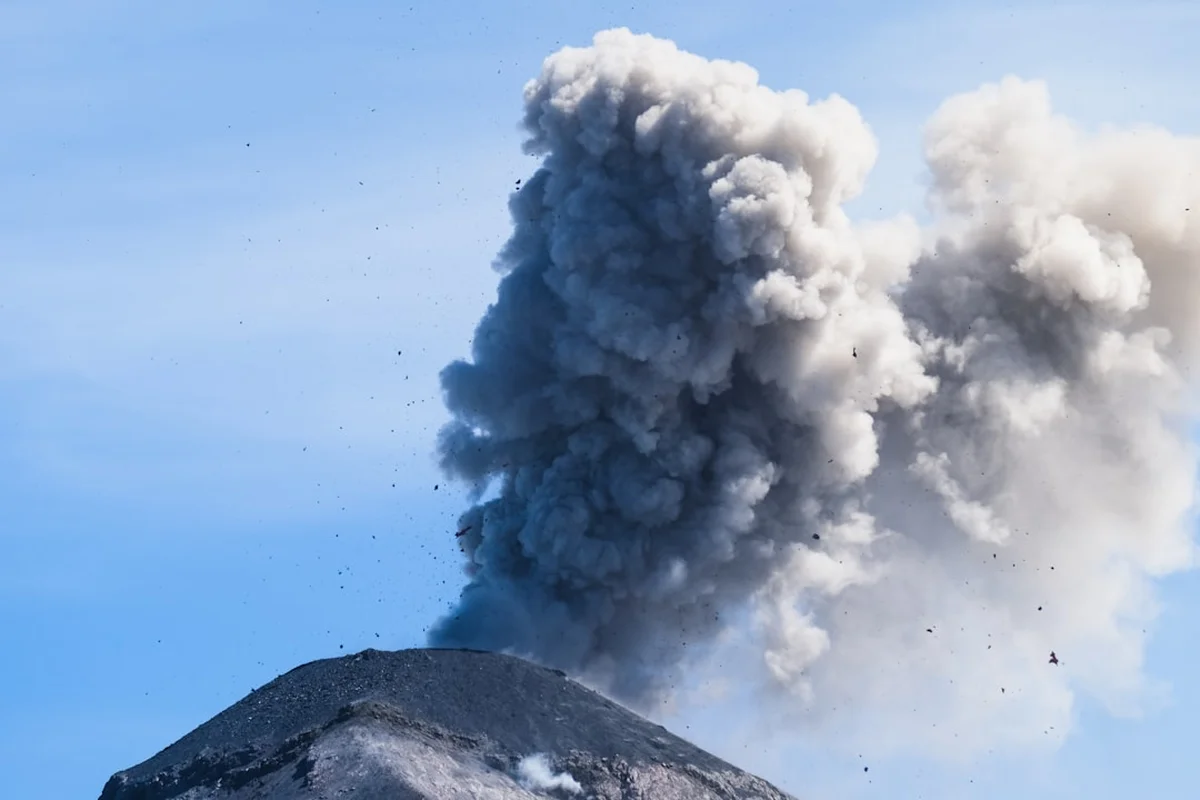
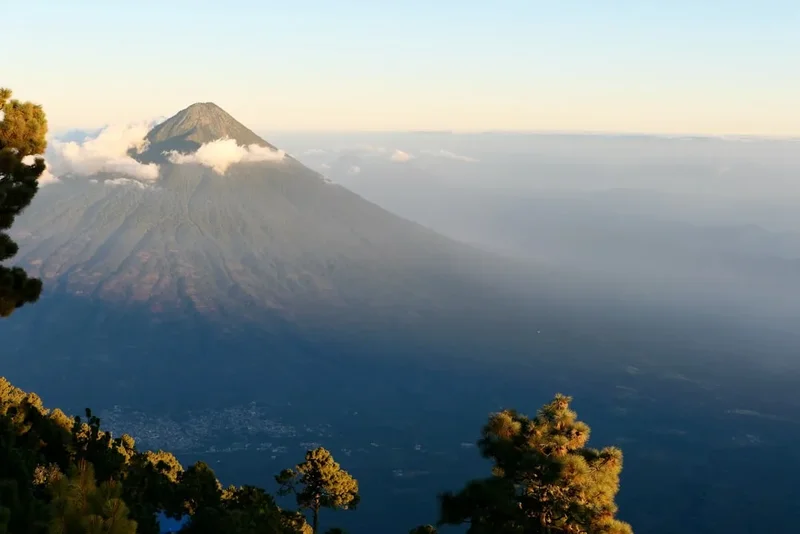
The physical demand of the hike is significant. The trail is often composed of loose volcanic sand and gravel, colloquially known as "scree," which can make every step feel like two steps forward and one step back. However, the reward for this exertion is unparalleled. Upon reaching base camp at approximately 3,600 metres, the view opens up to reveal the Pacific coastal plain to the south and the jagged spine of the Sierra de los Cuchumatanes to the north. But the true spectacle lies directly across the valley. Volcán de Fuego, an "open-vent" stratovolcano, erupts with startling frequency—often every 15 to 20 minutes. During the day, these eruptions send massive plumes of grey ash into the atmosphere. At night, the spectacle transforms into a pyrotechnic display of glowing lava bombs and incandescent flows that cascade down the volcano's flanks. The sound of these eruptions, a deep, guttural roar that vibrates in the chest, is something that stays with a hiker long after they have descended.
While many attempt the hike as a day trip, the overnight experience is strongly recommended. The transition from a golden sunset over the clouds to a star-studded night punctuated by volcanic fire is the essence of the Acatenango experience. It is a journey that tests the limits of one's legs and lungs, but provides a perspective on the natural world that is both terrifying and profoundly beautiful. Proper preparation, including acclimatisation in Antigua and the selection of a reputable guide service, is essential to ensuring a safe and rewarding expedition.
History and Cultural Context
Acatenango, along with its twin peak Volcán de Fuego, forms the "La Horqueta" volcanic complex. The history of these peaks is deeply intertwined with the indigenous Maya people of the region, specifically the Kaqchikel. For centuries, these volcanoes have been viewed as powerful spiritual entities, often associated with deities of fire and earth. The name "Acatenango" is derived from the Nahuatl language, meaning "fenced town" or "place of the reeds," reflecting the influence of Mexican indigenous allies who accompanied Spanish conquistadors to the region in the 16th century. While Acatenango itself has been relatively quiet in modern times, its last major eruptive period occurred between 1924 and 1927, with a smaller phreatic eruption in 1972. In contrast, Fuego has been in a state of near-constant activity since the Spanish colonial era, with its 1974 and 2018 eruptions being among the most devastating in Guatemalan history.
The development of Acatenango as a premier hiking destination is a relatively recent phenomenon. For much of the 20th century, the volcano was the domain of local hunters and a few intrepid mountaineers. It wasn't until the late 1990s and early 2000s that organised tourism began to take root. Today, the hike is a vital economic engine for the local community of La Soledad. Many of the guides and porters are former farmers who have transitioned into the tourism industry, bringing with them an intimate knowledge of the mountain's moods and trails. This shift has fostered a sense of stewardship over the volcano, although the rapid increase in visitor numbers has also brought challenges regarding waste management and environmental preservation.
Culturally, the volcano remains a symbol of Guatemalan identity. It appears in literature, art, and the daily lives of those living in its shadow. For the hikers who climb it, the experience often transcends sport; it becomes a pilgrimage to witness the primordial forces that shaped the Central American isthmus. The land is a reminder of the precarious balance between the fertility provided by volcanic ash and the destructive potential of the magma beneath. Understanding this history—both geological and human—adds a layer of depth to the trek, transforming it from a physical exercise into a connection with the deep time of the Earth.
Want more background? Read extended notes on history and cultural context → Learn more
Seasonal Highlights and Weather Reality
The weather on Acatenango is the single most important factor in determining the quality of the experience. Guatemala has two primary seasons: the dry season (Verano) and the wet season (Invierno). Choosing the right window for your hike is crucial for both safety and visibility.
Dry Season (November to April): This is the peak window for hiking Acatenango. During these months, the skies are typically clear, providing the best chances of seeing Fuego's eruptions and the spectacular sunrises and sunsets. November and December are particularly favoured for their crisp, clear air, though they are also the coldest months. In January and February, strong winds can become a factor, sometimes reaching speeds that make the summit push difficult. The "Canícula," a brief dry spell that often occurs in July or August, can also provide a temporary window of good weather during the rainy season, but it is less predictable.
Wet Season (May to October): Hiking during the rainy season is a gamble. While mornings may start clear, heavy afternoon downpours are common, often accompanied by thick cloud cover that can completely obscure the views of Fuego. The trail becomes muddy and slippery, increasing the physical difficulty. Furthermore, the risk of lightning on the exposed upper slopes is a genuine safety concern. However, the landscape is at its most vibrant and green during this time, and the cloud forest is particularly atmospheric.
Temperature Reality: Regardless of the season, hikers must be prepared for extreme temperature fluctuations. While Antigua may be a balmy 25°C, the temperature at base camp (3,600 m) frequently drops below freezing (0°C to -5°C) at night. On the summit, wind chill can make it feel significantly colder. Hypothermia is a real risk for those who are under-equipped. Conversely, the lower slopes can be intensely hot and dusty during the day, requiring careful sun protection and hydration management. Always check the mountain-specific forecast before departing, as weather systems can move in rapidly from the Pacific Ocean.
Recommended Itinerary
2-Day Acatenango Overnight Itinerary
Day 1: La Soledad to Base Camp
- Distance: 6.5 km
- Elevation gain: 1,200 m
- Time: 5–6 hours
- Morning departure from Antigua (approx. 08:00) for the 1-hour drive to La Soledad
- Registration at the trailhead and meeting with guides/porters
- The first hour is a steep climb through agricultural fields (corn and beans)
- Entry into the cloud forest zone; the gradient remains steep but the shade provides relief
- Midday lunch break at a designated rest area (often the "Tropical" station)
- Afternoon trek through the high-alpine pine forest as the air thins and cools
- Arrival at base camp (approx. 3,600 m) by mid-afternoon
- Evening spent watching Fuego erupt as the sun sets and the lava becomes visible
- Dinner at camp and early sleep in preparation for the summit push
Day 2: Summit Push and Descent
- Distance: 11.5 km (including summit and full descent)
- Elevation: 376 m gain to summit, 1,576 m descent to trailhead
- Time: 6–8 hours total
- Wake-up call at 03:30 or 04:00 for the final ascent
- The summit push is the most difficult part: a steep, 1-hour climb through loose volcanic scree in the dark
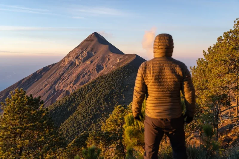
- Arrival at the summit (3,976 m) for sunrise; views of the entire volcanic chain (Agua, Fuego, Atitlán, and even Tacaná on the Mexican border)
- Descent back to base camp for a quick breakfast and packing
- The descent follows a different, more direct route through the "slide" (loose sand) which is much faster but hard on the knees
- Return to La Soledad by midday
- Transport back to Antigua, arriving by 14:00 or 15:00
Important Notes:
- Guides are strongly recommended for navigation and safety
- The "Fuego Ridge" hike is an optional add-on on Day 1 for those with exceptional fitness (adds 3-4 hours and 400m elevation)
- Altitude sickness (soroche) is common; listen to your body and communicate with your guide
- Dust masks or buffs are essential for the descent to protect lungs from volcanic ash
- Ensure your headlamp has fresh batteries for the pre-dawn summit climb
Planning and Bookings
Book Your Trip
Everything you need to plan your journey
Accommodation
Find places to stay near Antigua
Flights
Search flights to Antigua
Essential Preparation
The Acatenango hike is a significant physical undertaking that should not be underestimated. Preparation begins with acclimatisation. It is highly recommended to spend at least 48 to 72 hours in Antigua (1,500 m) or Lake Atitlán (1,560 m) before attempting the climb. Attempting the hike directly after arriving from sea level significantly increases the risk of Acute Mountain Sickness (AMS). Fitness preparation should focus on cardiovascular endurance and leg strength; stair climbing or hiking with a weighted pack are excellent ways to prepare for the 1,900-metre vertical gain.
Logistically, most hikers book through one of the many tour operators in Antigua. These companies typically provide transport, guides, meals, and camping equipment. When choosing an operator, prioritise those with a reputation for fair wages for porters, high-quality cold-weather gear, and environmental responsibility. If you are a solo traveller, joining a group is the most cost-effective and social way to experience the volcano. For those who prefer independence, it is possible to hire a local guide at the trailhead in La Soledad, though you will need to provide all your own gear and food.
Trail Accommodation
Accommodation on Acatenango is rustic and designed for utility rather than luxury. Most hikers stay in base camps located on the eastern or northern slopes of the volcano, positioned to provide views of Volcán de Fuego.
Hut and Camp Facilities:
- Tents or wooden A-frame cabins (depending on the operator)
- Sleeping mats and heavy-duty sleeping bags (usually provided by tour companies)
- Basic pit toilets or composting toilets (facilities vary by camp)
- Central campfire area for cooking and warmth
- No running water or electricity
- No WiFi or reliable mobile signal
What Camps Don't Provide:
- Pillows or luxury bedding
- Heating (the campfire is the only source of warmth)
- Charging stations for electronics
- Showers or washing facilities
- Privacy (most cabins and tents are shared)
Booking Requirements:
- Bookings can be made months in advance or as late as the day before in Antigua
- During peak season (December-January), popular operators can sell out several days in advance
- Costs vary widely: Budget operators charge approx. US$50-70, while premium operators with private cabins can charge US$100-150
- The entrance fee (50 Quetzales) is sometimes included in the tour price, but often paid separately at the trailhead
Required Gear
- Hiking boots - Essential. Must have good tread for loose scree and be broken in
- Layered clothing - Moisture-wicking base layer, insulating fleece/down mid-layer, and a windproof/waterproof outer shell
- Warm hat and gloves - Temperatures at the summit and base camp are often below freezing
- Hiking socks - Merino wool is best to prevent blisters and keep feet warm when damp
- Backpack - 40-50L if carrying your own gear; 20-30L if hiring a porter
- Headlamp - Mandatory for the sunrise summit push and navigating camp at night
- Trekking poles - Highly recommended for the steep descent to save your knees
- Buff or bandana - To protect your face and lungs from dust and volcanic ash
- Sun protection - High SPF sunscreen, sunglasses, and a wide-brimmed hat
What to Bring
- Water - 4 litres per person is the standard requirement (2L for the ascent, 1L for camp, 1L for the descent)
- Snacks - High-energy items like nuts, chocolate, dried fruit, and energy bars
- Personal medications - Including ibuprofen or acetazolamide for altitude symptoms
- Toiletries - Toilet paper, hand sanitiser, and wet wipes (no showers available)
- Power bank - To keep phone/camera charged for photos of Fuego
- Cash - Small denominations of Quetzales for tips, snacks at the trailhead, or hiring a last-minute porter
- Plastic bags - To keep clothes dry inside your pack and to pack out your trash
- Earplugs - Fuego's eruptions can be loud enough to wake you up at night
Permits
The permit system for Acatenango is relatively straightforward compared to many international treks. There is no centralised online booking system for permits; instead, they are managed locally by the community and the municipal authorities of Acatenango and San Miguel Dueñas.
Permit Process:
- Registration occurs at the visitor centre in the village of La Soledad
- Every hiker must sign the registry and pay the entrance fee
- The current fee is 50 Quetzales (approx. US$6.50) for international visitors
- You will receive a paper ticket; keep this safe as it may be checked by rangers on the trail
- If you are with a tour company, they often handle the registration process for you, but you should confirm if the fee is included in your package
Guide Requirements:
- While not strictly mandatory by law for experienced mountaineers, the local authorities and community strongly discourage unguided hikes
- The trail has several forks that can be confusing in the fog or at night
- In recent years, there have been safety incidents involving lost hikers and robberies on unguided sections; hiring a guide is a contribution to local security and the economy
- If you choose to go without a tour company, you can hire a local guide at the La Soledad visitor centre for approximately 200-300 Quetzales
Porters:
- Porters are available at the trailhead and are a fantastic way to support the local economy while making your hike more enjoyable
- A porter can carry up to 20kg of your gear to base camp
- The cost is typically 200 Quetzales (approx. US$25) each way
- Hiring a porter allows you to focus on the climb and reduces the physical strain of the altitude
Other Activities in the Area
Antigua and the surrounding highlands offer a wealth of experiences to complement your volcano trek:
- Antigua Walking Tour: Explore the UNESCO World Heritage city, famous for its well-preserved Spanish Baroque architecture, ruined colonial churches, and vibrant markets.
- Coffee Plantation Tours: The slopes of the volcanoes produce some of the world's finest coffee. Visit a "finca" to learn about the process from bean to cup.
- Volcán Pacaya: For a less strenuous volcanic experience, Pacaya offers the chance to see active lava flows (depending on current activity) with a much shorter hike.
- Lake Atitlán: A three-hour drive from Antigua, this stunning crater lake is surrounded by three volcanoes and indigenous Mayan villages, perfect for post-hike relaxation.
- Chocolate Workshops: Guatemala is the birthplace of chocolate. Many shops in Antigua offer workshops where you can grind your own cacao beans.
- Hobbitenango: An eco-park and restaurant located on a ridge overlooking the Panchoy Valley, offering "Lord of the Rings" inspired architecture and great views.
Safety and Conditions
Altitude Sickness (AMS): At nearly 4,000 metres, altitude is the primary safety concern. Symptoms include headache, nausea, dizziness, and fatigue. The best prevention is slow ascent and proper hydration. If symptoms become severe (confusion, shortness of breath at rest), the only cure is immediate descent. Most guides carry basic first aid, but you should be responsible for your own health monitoring.
Volcanic Hazards: While Acatenango is dormant, its neighbour Fuego is extremely active. Hikers should never attempt to cross the saddle to Fuego without an experienced guide and a clear understanding of the current alert levels. Volcanic ash can be an irritant to the eyes and lungs; wearing a buff and sunglasses is essential. In the event of a major eruption, follow your guide's instructions immediately—they are in contact with local monitoring stations.
Weather Extremes: Hypothermia is a genuine risk. The combination of sweat from the climb and the freezing temperatures at base camp can be dangerous. Always change into dry clothes immediately upon arriving at camp. During the rainy season, lightning is a significant hazard on the exposed summit; if a storm approaches, descend below the treeline immediately.
Trail Conditions: The volcanic scree is unstable. Ankle sprains are the most common injury on the descent. Use trekking poles and take short, controlled steps. The "dust" on the trail can be thick; if you have asthma or respiratory issues, take extra precautions.
Security: In the past, there were reports of robberies on the volcano. However, increased police presence (DISETUR) and the organised guide system have made the trail significantly safer. It is still advised to hike in groups and avoid carrying unnecessary valuables.
Side Trips and Points of Interest
The Fuego Ridge (The "Double Whammy"): For those with high fitness levels, many operators offer an optional trek from Acatenango base camp across the saddle to the shoulder of Volcán de Fuego. This adds approximately 3 to 4 hours of hiking and involves a steep descent and re-ascent. It brings you within a few hundred metres of the active vent, providing an earth-shakingly close perspective of the eruptions. This should only be done with a professional guide and in good weather.
The Crater Rim: The summit of Acatenango is actually a large, rounded crater. Walking the full circumference of the rim provides 360-degree views and allows you to see the different vents and geological formations of the peak. On a clear day, you can see the Pacific Ocean and the volcanoes of El Salvador to the south-east.
The Cloud Forest Epiphytes: Take time during the middle section of the ascent to observe the incredible biodiversity. The cloud forest is home to rare birds, including the Resplendent Quetzal (though sightings are rare), and an array of orchids and bromeliads that thrive in the misty environment.
Sunrise at the Summit: While technically part of the main itinerary, the summit experience is the ultimate "point of interest." Watching the triangular shadow of Acatenango cast across the clouds to the west as the sun rises over the Atlantic side of Guatemala is a world-class photographic opportunity.
Leave No Trace
The popularity of Acatenango has put significant pressure on its fragile ecosystems. As a hiker, you have a responsibility to minimise your impact to ensure the volcano remains a viable destination for future generations.
Leave No Trace Principles:
- Pack it in, pack it out: There is no trash collection on the volcano. Every piece of plastic, food wrapper, and cigarette butt must be carried back down to Antigua. Many operators now lead "clean-up" hikes; consider picking up any stray trash you see.
- Dispose of waste properly: Use the designated toilets at base camps. If you must go on the trail, dig a "cathole" at least 15cm deep and 60m away from the trail and any water sources. Pack out your toilet paper.
- Stay on the trail: Cutting switchbacks causes severe erosion on the steep volcanic slopes and destroys fragile alpine vegetation.
- Respect wildlife: Do not feed any animals you encounter. Observe from a distance.
- Minimise campfire impact: Only use established fire rings at base camps. Do not cut live wood; use only what is provided by your guides.
- Be considerate of others: Many people climb Acatenango for the solitude and the sounds of nature (and the volcano). Keep noise levels down at base camp, especially after 20:00.