Abel Tasman Coast Track - New Zealand's Coastal Paradise
The Abel Tasman Coast Track is arguably New Zealand's most popular Great Walk, offering a stunning 60-kilometre journey through the smallest but most visited national park in the country. Located at the top of the South Island, this track is a coastal masterpiece, weaving through lush native forest and emerging onto crescent-shaped beaches of golden granitic sand. Unlike the rugged alpine challenges of the Milford or Routeburn tracks, the Abel Tasman is celebrated for its accessibility, mild climate, and the unique flexibility provided by a fleet of water taxis that service almost every major bay. Walkers can choose to complete the entire route over several days or sample sections via boat transfers, making it a versatile adventure for families, solo travellers, and experienced trampers alike. The journey is defined by the rhythmic sound of the Tasman Sea, the inquisitive call of the tūī, and the dramatic transformation of the landscape as the massive tides of the region ebb and flow.
- Distance: 60.0 km one-way
- Duration: 3–5 days
- Season: Year-round (October to April is peak season)
- Huts: Anchorage, Bark Bay, Awaroa, Whariwharangi
- Highest point: 150 m (near Gibbs Hill)
- Difficulty: Moderate (well-formed track, gentle gradients)
- Direction: Usually walked south to north (Marahau to Wainui)
Overview
The Abel Tasman Coast Track is a sensory experience that contrasts the deep greens of New Zealand's temperate rainforest with the brilliant turquoise of the Pacific Ocean. The track is meticulously maintained by the Department of Conservation (DOC), featuring wide, well-graded paths that rarely exceed a gentle incline. This makes it an ideal "entry-level" Great Walk, though the total distance of 60 kilometres still requires a reasonable level of fitness and endurance. The landscape is dominated by "Separation Point Granite," a geological formation that has weathered over millennia to create the iconic golden sands that define the park's aesthetic. As you walk, you will transition from coastal shrublands and mānuka groves into towering podocarp forests where ancient rimu and northern rātā dominate the canopy.
One of the most defining characteristics of the Abel Tasman is its tidal nature. The region experiences a tidal range of up to six metres, which fundamentally alters the track's geography twice a day. Several sections, most notably the Awaroa Inlet, can only be crossed within a specific window around low tide. This adds a layer of logistical complexity and "wildness" to the walk, as trampers must consult tide tables with the same diligence that alpine hikers consult weather forecasts. When the tide is out, vast estuaries reveal intricate patterns in the sand and provide shortcuts across bays; when the tide is in, the sea pushes right up to the forest edge, forcing walkers onto high-tide tracks that wind through the hills.
Wildlife is a constant companion on the track. The park is home to a thriving population of New Zealand fur seals (kekeno), particularly around the Tonga Island Marine Reserve. In the forest, the birdsong is prolific. Thanks to extensive predator control efforts, you are likely to encounter the North Island robin (toutouwai), the fantail (pīwakawaka), and the kererū (New Zealand pigeon). Along the shoreline, variable oystercatchers and reef herons are common sights. The Abel Tasman is not just a walk; it is an immersion into a coastal ecosystem where the boundary between land and sea is beautifully blurred.
History and Cultural Context
The history of the Abel Tasman region is a rich tapestry of Māori heritage and early European exploration. For centuries, the coastline was home to various iwi (tribes), including Ngāti Tūmatakōkiri, and later Ngāti Rārua and Te Āti Awa. The area provided a bountiful "mahinga kai" (food gathering place), with the sea offering fish and shellfish, while the forests provided birds and plant materials. Many of the bays still bear names that reflect this history, and archaeological sites, including pā (fortified villages) and middens, are scattered throughout the park, reminding visitors of the deep ancestral connection to this land.
The park's European history began in December 1642, when Dutch explorer Abel Janszoon Tasman anchored his two ships, the Heemskerck and the Zeehaen, in what is now known as Golden Bay. This was the first recorded encounter between Europeans and Māori. The meeting was fraught with misunderstanding and ended in a violent skirmish at "Moordenaars" (Murderers) Bay, leading Tasman to sail away without ever setting foot on New Zealand soil. It wasn't until 1770 that Captain James Cook sailed past, followed by the French explorer Dumont d'Urville in 1827, who spent several days exploring the sheltered waters of the Astrolabe Roadstead, naming many of the islands and landmarks after his crew and ships.
In the late 19th and early 20th centuries, the area was used for logging, quarrying, and small-scale farming. However, the rugged terrain made large-scale development difficult. The vision for a national park was championed by Pérrine Moncrieff, a conservationist and author who became concerned about the loss of native forest. Her tireless advocacy led to the formal establishment of the Abel Tasman National Park in 1942, coinciding with the 300th anniversary of Tasman's visit. The park was opened by the Governor-General on behalf of Queen Wilhelmina of the Netherlands, cementing a unique international bond that continues to this day.
Want more background? Read extended notes on history and cultural context → Learn more
Seasonal Highlights and Weather Reality
The Abel Tasman Coast Track is one of the few Great Walks that remains fully accessible and safe throughout the year. The Nelson-Tasman region is famous for having some of the highest sunshine hours in New Zealand, which contributes to the track's popularity in all seasons. However, each season offers a distinct experience for the walker.
Summer (December to February): This is the peak season. The weather is warm (20–25°C), the water is inviting for swimming, and the park is buzzing with energy. This is the best time for kayaking and enjoying the beaches, but it is also when the track and huts are most crowded. Bookings must be made months in advance, and you will share the trail with many day-trippers. The sun is exceptionally strong in New Zealand, so high-SPF sunscreen is mandatory.
Autumn (March to May): Many locals consider this the best time to walk. The summer crowds have thinned, the sea remains warm enough for a dip, and the weather is often settled and calm. The light in autumn is particularly beautiful for photography, with crisp mornings and golden afternoons.
Winter (June to August): Winter in the Abel Tasman is surprisingly pleasant. While the nights are cold (sometimes dropping to 0°C), the days are often characterised by "bluebird" skies and no wind. The clarity of the air provides stunning views across the Tasman Bay to the Richmond Ranges. You will have the huts and beaches largely to yourself, though you will need warmer layers for the evenings.
Spring (September to November): Spring brings a burst of new growth and birdsong. The weather can be more variable, with occasional rain showers and "equinoctial gales," but the forest is at its most vibrant. The kōwhai trees bloom with yellow flowers, attracting nectar-feeding birds like the tūī and bellbird (korimako).
Recommended Itinerary
5-Day Abel Tasman Coast Track Itinerary
Day 1: Marahau to Anchorage
- Distance: 12.4 km
- Elevation gain: 150 m
- Time: 4 hours
- Start at the Marahau causeway at the southern park entrance.
- The track winds through open country and mānuka scrub before entering the forest.
- Enjoy views of the Astrolabe Roadstead and Adele Island (Motuareronui).
- Pass Tinline Bay and Coquille Bay, both excellent spots for a first swim.
- Arrive at Anchorage Hut/Campsite, a large and popular hub with a beautiful sweeping beach.
- Optional: Take the short side trip to Te Pukatea Bay for a more secluded evening.
Day 2: Anchorage to Bark Bay
- Distance: 11.5 km (high tide) or 8.4 km (low tide)
- Elevation gain: 120 m
- Time: 3–4 hours
- Crucial: Check the tide for the Torrent Bay estuary crossing.
- Low Tide Route: Walk directly across the estuary (approx. 1–2 hours either side of low tide).
- High Tide Route: A longer track that loops around the estuary through the forest.
- Pass through the small settlement of Torrent Bay (private holiday homes).
- Cross the impressive Falls River swing bridge (47 metres long).
- Arrive at Bark Bay, which features a tidal lagoon and a stunning golden sand spit.
Day 3: Bark Bay to Awaroa
- Distance: 13.5 km
- Elevation gain: 140 m
- Time: 4–4.5 hours
- The track climbs over a ridge and descends into Tonga Quarry, where granite was once extracted.
- Walk along the beautiful Onetahuti Beach, a long crescent of sand.
- The track then climbs again through lush forest before descending to Awaroa.
- Arrive at Awaroa Hut, situated near the famous "People's Beach" (purchased via crowdfunding in 2016).
- Note: The Awaroa Lodge (private) is nearby if you fancy a cold drink or a meal.
Day 4: Awaroa to Whariwharangi Bay
- Distance: 16.9 km
- Elevation gain: 200 m
- Time: 5.5–6 hours
- CRITICAL: You must cross the Awaroa Inlet within 1.5 hours before or 2 hours after low tide. There is no high-tide alternative.
- After the crossing, the track enters a more remote and rugged section of the park.
- Pass through Totaranui, a large campsite and road-accessible hub.
- The track climbs over a headland to Anapai Bay and Mutton Cove.
- Continue over the final ridge to Whariwharangi Bay.
- Stay in the historic Whariwharangi Hut, a restored farm homestead built in 1896.
Day 5: Whariwharangi Bay to Wainui Inlet
- Distance: 5.7 km
- Elevation gain: 100 m
- Time: 2 hours
- The final stretch follows the coastline around to the Wainui Inlet.
- Alternatively, take the Gibbs Hill track for panoramic views of Golden Bay and the Tasman Sea.
- The track ends at the Wainui car park.
- Arrange a pre-booked shuttle to take you back to Marahau or Nelson.
Important Notes:
- Tide tables are the most important planning tool for this track.
- Water taxis do not service the section north of Totaranui.
- All huts and campsites must be booked in advance via the DOC website.
- Drinking water is available at all huts but should be treated.
- The track is well-signposted, but a map is still recommended.
Planning and Bookings
Book Your Trip
Everything you need to plan your journey
Accommodation
Find places to stay near Nelson
Flights
Search flights to Nelson
Essential Preparation
The Abel Tasman Coast Track requires careful logistical planning, primarily due to the tidal crossings and the need for transport coordination. Unlike many other Great Walks, you have the option to use water taxis to drop off or pick up gear, or even to skip sections of the track. This makes it highly customisable. You should base yourself in Nelson or Motueka before the hike. Marahau is the main gateway, where most water taxi operators and sea kayaking companies are based. There is a large public car park at Marahau, but it can fill up quickly in summer.
Fitness requirements are moderate. While the track is well-formed, walking 12–17 kilometres a day with a pack requires stamina. If you are not used to multi-day hiking, consider using a "pack transfer" service offered by water taxi companies, allowing you to walk with only a day pack while your heavy gear is boated to your next overnight stop.
Trail Accommodation
There are four Department of Conservation (DOC) huts and 18 campsites along the Abel Tasman Coast Track. During the peak season (October to April), these must be booked well in advance.
Hut Facilities:
- Bunk beds with mattresses in communal sleeping areas.
- Large common areas with tables and seating.
- Wood-burning heaters (for winter use).
- Filtered water (treatment still recommended).
- Flush toilets (at Anchorage, Bark Bay, and Awaroa) or composting toilets.
- No gas cooking facilities (you must bring your own stove).
- No lighting or power outlets.
Campsite Facilities:
- Designated tent sites, often right on the beachfront.
- Water supply and toilets.
- Some campsites have cooking shelters, but most are basic.
- Maximum stay of two consecutive nights at any one campsite.
Costs: Hut prices range from NZ$32 to NZ$75 per night depending on residency and season. Campsites are significantly cheaper, usually around NZ$15 to NZ$30 per night. Always check the latest prices on the DOC website as they are subject to annual review.
Required Gear
- Footwear: Sturdy walking shoes or light tramping boots. The track is not overly technical, so heavy boots are rarely necessary.
- Sandals or Water Shoes: Essential for tidal crossings (Awaroa and Torrent Bay) to protect your feet from sharp shells and stones.
- Rain Jacket: A high-quality waterproof shell. Even in "Sunny Nelson," coastal storms can arrive quickly.
- Pack: A 40–60L pack for multi-day hikers, or a 20L day pack if using pack transfers.
- Sleeping Bag: A 2-season bag is sufficient for summer; a 3-season bag is recommended for winter.
- Clothing: Layering is key. Use merino or synthetic base layers (no cotton). Bring a warm fleece or down jacket for the evenings.
- Sun Protection: SPF 50+ sunscreen, a wide-brimmed hat, and quality sunglasses.
- First Aid: Blister plasters, antiseptic cream, and any personal medications.
What to Bring
- Food: All food for the duration of your trip. There are no shops in the park (except for the seasonal cafe at Awaroa). Focus on lightweight, high-energy meals.
- Cooking Equipment: A portable gas stove, fuel, matches/lighter, and a lightweight pot set.
- Water Treatment: While water is provided at huts, it is untreated. Bring a filter, UV purifier, or chlorine tablets.
- Eating Utensils: Bowl, mug, spoon, and knife.
- Toiletries: Biodegradable soap, toothbrush, and a small towel.
- Headlamp: With spare batteries for navigating the huts at night.
- Tide Table: A printed copy of the tide table for your specific dates is non-negotiable.
- Insect Repellent: Sandflies (namu) can be persistent at certain beaches; a repellent with DEET or Picaridin is effective.
Permits
There is no "permit" required to walk the Abel Tasman Coast Track in the sense of a daily entry fee. However, your hut or campsite booking serves as your permit to stay overnight in the park. You must carry a printed or digital copy of your booking confirmation at all times, as DOC rangers frequently patrol the track and huts to verify bookings.
Booking Process:
- Bookings are made through the DOC Great Walks booking website.
- For the peak summer season (December–January), bookings often open in May or June and can sell out for popular dates within hours.
- If you are planning a trip during the shoulder season, you can often find availability a few weeks out.
- Day walkers do not need to book or pay any fees to use the track.
Water Taxi and Shuttle Costs: These are separate from your DOC bookings. A water taxi from Marahau to Anchorage typically costs around NZ$40–$50 per person. A shuttle from Wainui back to Marahau or Nelson can cost between NZ$50 and NZ$80 depending on the operator and group size. It is highly recommended to book these in advance, especially in summer.
Other Activities in the Area
The Abel Tasman National Park is a playground for outdoor enthusiasts. Many visitors choose to combine their walk with other activities to experience the park from different perspectives:
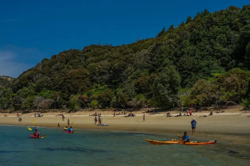
- Sea Kayaking: This is the most popular alternative to walking. You can hire kayaks for independent use (if you have experience) or join a guided tour. Paddling into the sea caves and around the islands allows you to see the seal colonies up close.
- Sailing: Several operators offer day sails or overnight charters through the park. It is a serene way to experience the coastline without the physical exertion of walking.
- Canyoning: For the adrenaline seekers, the Torrent River offers a world-class canyoning experience involving abseiling, sliding down waterfalls, and jumping into deep pools.
- Snorkelling: The Tonga Island Marine Reserve is a fantastic spot for snorkelling. The clear water allows you to see a variety of fish species and the kelp forests that thrive in the protected area.
- Skydiving: For a truly unique view, you can skydive over the park from Motueka, providing a bird's-eye view of both the Abel Tasman and Kahurangi National Parks.
Safety and Conditions
Tidal Crossings: The single greatest safety concern on the Abel Tasman Coast Track is the tidal crossings. The Awaroa Inlet is the most critical. Attempting to cross outside the recommended window (1.5 hours before to 2 hours after low tide) is dangerous. The tide comes in quickly, and the sandy bottom can become unstable. If you miss the window, you must wait for the next low tide; there is no high-tide track around Awaroa.
Sun Exposure: The New Zealand sun is exceptionally harsh due to low atmospheric pollution and a thinner ozone layer. Heat exhaustion and severe sunburn are common among unprepared walkers. Drink plenty of water (at least 2–3 litres per day) and wear protective clothing.
Water Safety: While the beaches look calm, always be cautious when swimming. Watch for currents near estuary mouths and be aware that the water temperature, while pleasant in summer, can still cause hypothermia if you stay in too long during the cooler months.
Wasps: During late summer and autumn (February to April), German and common wasps can be a significant nuisance in the beech forests. They are attracted to the honeydew produced by scale insects. If you have a known allergy to wasp stings, you must carry an antihistamine or EpiPen.
Communication: Mobile phone coverage is patchy throughout the park. It is generally available on high ridges and at some of the main beaches (like Anchorage), but do not rely on it for emergencies. Carrying a Personal Locator Beacon (PLB) is highly recommended, especially if you are walking the more remote northern sections.
Side Trips and Points of Interest
Cleopatra's Pool: Located a short 20-minute walk from the Torrent Bay high-tide track, this is a natural rock pool with a moss-lined water slide. It is a perfect spot for a refreshing dip and a picnic. The water is crystal clear and cold, fed by the Falls River.
Separation Point (Te Pukatea): This is the geographical marker where Tasman Bay meets Golden Bay. A side trip from the main track near Whariwharangi takes you to the lighthouse. It is a prime spot for viewing the seal colony and, if you are lucky, spotting gannets diving for fish or even a passing pod of orca or dolphins.
Harwoods Hole: While not directly on the Coast Track, this is a popular nearby attraction in the park's interior (accessed via Canaan Road). It is New Zealand's deepest vertical shaft (176 metres). The walk to the lookout offers a dramatic contrast to the coastal scenery, featuring karst limestone landscapes and ancient beech forest.
Pitt Head Lookout: Near Anchorage, this short loop track offers some of the best panoramic views in the park. You can see the entire sweep of Torrent Bay and the distant mountains of the Kahurangi National Park. It is also a great place to see the remains of an ancient Māori pā site.
Leave No Trace
The Abel Tasman National Park is a precious and fragile environment. With over 200,000 visitors a year, the cumulative impact can be significant. Following the Leave No Trace principles is essential to ensure the park remains pristine for future generations.
Key Principles for the Abel Tasman:
- Dispose of Waste Properly: There are no rubbish bins in the park. Everything you carry in, you must carry out. This includes food scraps and organic waste, which can attract pests like rats and stoats.
- Respect Wildlife: Keep a distance of at least 20 metres from seals. Never feed the birds, as this can make them dependent on humans and lead to aggressive behaviour (especially from the cheeky weka).
- Stay on the Track: To prevent erosion and protect the delicate root systems of the forest, always stay on the marked paths.
- Be Considerate of Others: The Abel Tasman is a social track, but many people come for the peace of nature. Keep noise levels down in the huts and campsites.
- Water Protection: Use biodegradable soaps and wash at least 50 metres away from any water source. Do not use soap directly in the sea or streams.